Manila Discussion archive for:
  • Cottonwood Meadows and Buck Lake

    After my experience a couple weeks ago on the Cottonwood Trail, I decided to go back and try the cross country route again.  This time, I was successful.  I didn't even need the GPS coordinates posted here, however they looked to be very accurate.  The "mid point" didn't seem to be halfway through the clearcut, it was the first road I came to, which was closer to the southern edge of the clearcut.

    Once through the clearcut, picking up the trail on the other end wasn't too difficult.  I had to venture down the hill a bit before I saw the flagging, but once I saw it, it was easy to get the trail.  I have to say, the southern part of that trail is an EXCELLENT trail.  It has a fair amount of elevation change on it, but except for the very end, it is VERY well graded.  The trip through that part of the forest is absolutely beautiful!  A couple of spots had vine maple up and down the hill in yellow.  On the way back, I did a little brush trimming at the bottom of the hill, hoping to make the route a little clearer to see.  If I had flagging tape with me, I would have added a few more flags.

    Once down at the southern end of the trail, I decided to hike down the 4635-120 spur to the "Collapsed bridge over Cot Creek" just to see what it looked like.  Based on the construction of the bridge, it looks like that is a pretty old road.  The bridge looks to have been collapsed for quite a few years, too.

    I think you can still drive the 4635-120 road, so if you don't feel comfortable doing the cross country thing, I'd highly recommend taking this trail from the south end up to the clearcut.  Portions of it reminded me a lot of the lower section of the Rho Creek trail.

    On the way home, I decided to check out the short Buck Lake trail.  It is about a half mile into the lake, up a hill, but it was a rather interesting place.  There were a couple of cars at the trailhead, but I didn't see the people when I was up at the lake, just their stuff.  I was running late, so I didn't hike around the lake, I just snapped some pictures.

    All in all, a GREAT day.  My only disappointment was when I hiked up the east end of the Rimrock trail, hoping to go up the viewpoint trail on Mt Mitchell.  I had forgotten where the junction was, and didn't have time to go all the way up the trail, so I had to turn around and go back.  That viewpoint would have been awesome on Saturday.  The weather was pretty clear.

    I can highly recommend the Cottowood Meadows trail.  I'd love to get in there early in the season before the bugs.  I would think that once the huckleberries and other ground cover start leafing up, and the meadows being very wet, it would be a little tougher to navigate the meadows, but I'm sure the diversity and color would be amazing.
    Cottonwood Meadows and Buck Lake
  • Re: Cottonwood Meadows and Buck Lake (#)
  • Hey, I camp't at the southern TH late summer with my 4 year old.  We cleared (ok, Me) brush up to the clearcut.  Is the little metal T still up?  That's like my good housekeeping symbol.  They seem to help define the TH though.

    It reminds me of Rho Creek too.  I'd like to put some time next summer into clearing a defined route thru that clearcut.  It's too good a trail to remain cut off in the middle.

    • Re: Cottonwood Meadows and Buck Lake (#)
    • Yep, the little metal T is still up.  See here.   When i was going across the clearcut, there were sections where I almost thought I saw a trail.  With some good flagging, I don't think it would be too hard to make a trail through there....

      BTW, I found the collapsed bridge at Cot Creek very interesting.....I wonder how old those roads are?
      • Re: Cottonwood Meadows and Buck Lake (#)
      • Funny!  I have a really cute pic of my kid posing next to the sign.

        I didn't check out the bridge.  What vintage is it?  Is it made of wood?

        Rho Creek was impossible to find at first.  We'll clear that sucker out.  Probably next season.  I'm a trail-work lightweight, most of the sawing and really hard work gets done by other Advocates, and they humbly keep it to themselves.  I think that's pretty cool.  Although it would be exciting to read more about their exploits!

        Donovan, speaking of Rho Creek, could we get the Trail Listing updated with the new info?  It's not really abandoned any more.


        • Re: Cottonwood Meadows and Buck Lake (#)
        • I'll look at it. I'd rather represent it as tougher than easier than it is. That way, no one will be disappointed.
      • Re: Cottonwood Meadows and Buck Lake (#)
      • We all need to put our heads together and flag the route through the clearcut. Once established, it will evolve with use.
        • Re: Cottonwood Meadows and Buck Lake (#)
        • After doing it twice in a short period of time, I finally understood the directions you posted here.  If you basically follow the old "creek" (wash), it pretty much puts you out at the road, where you walk right and then left to the end of the second road and the lower part of the trail.  It could use a few more flags at the top of the hill where the road ends, too.

          I'd love to participate in flagging "the" route sometime next year.....This is too good a trail to keep a secret.
  • Re: Cottonwood Meadows and Buck Lake (#)
  • The bridge is made out of old logs, and the approaches are logs/rocks, not concrete or steel.  It almost looks like the deck of the bridge was planks.  It looks very old.

    You can see a picture of the old bridge here.  If you download the original image, you can zoom in and see some of the details.
    • Re: Cottonwood Meadows and Buck Lake (#)
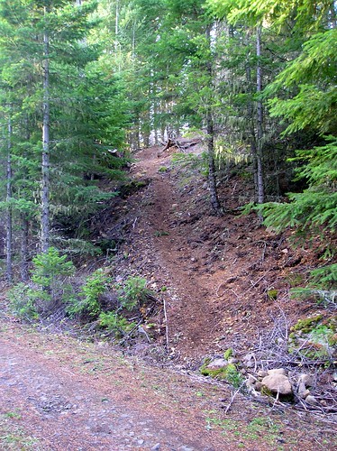
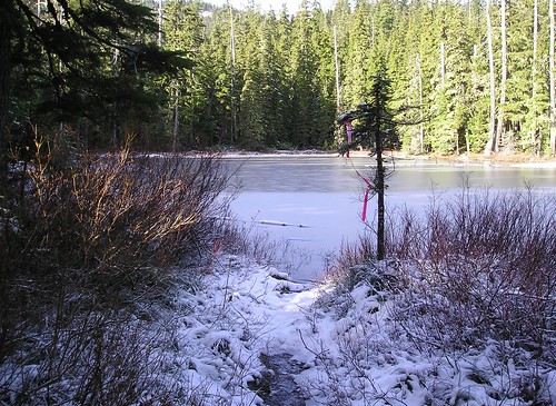
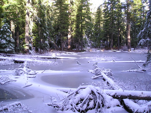
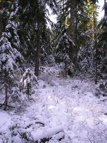
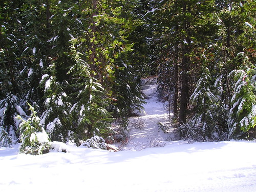
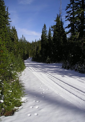
    • I thought the Cottonwood Meadows trail sounded interesting so I went to take a look at it today.  I started at the lower trailhead, but was disappointed that I did not find Robert's post with the metal "T."  Maybe it got knocked down.  As discussed earlier, this lower segment is a very good trail.  The clearcut area beyond that was somewhat confusing, but the excellent map provided in the trail index helped me find my way across.  Beyond that, though, things got a little dicey with flooded trail, frozen ponds and snow.  I had to bushwhack around a couple of the ponds (in the snow), and eventually found my way up to the upper trailhead, or close to it, as I had to circumvent one last flooded stretch of trail.  I had planned to continue on up the Rimrock Trail for a better view of the area, but with snow on the trail I changed my mind.  I will have to admit that I wimped out on the return route and opted to walk down the open, sunny road rather than face the dark, snowy, soggy trail again.  

      I will come back again next year, probably earlier in the fall when the meadows are dry and the mosquitoes are gone.  It's a beautiful area, and I'd like to explore it some more.

      More pictures here.


      • Re: Cottonwood Meadows and Buck Lake (#)
      • That pile of rocks in your southern trailhead picture looks like where the post used to be.  You can see it here in the right hand section of the picture.  Bummer that it is gone....

        I can imagine the snow that was there.  The first time I was up there, it had a little snow (2-3") and it made it tougher going.  I didn't have to deal with wet meadows, however.  I think it would absolutely awesome in the spring, after the snow is gone, but before the bugs hatch.

        Nice pictures - Thanks for sharing

        Rob
        • Re: Cottonwood Meadows and Buck Lake (#)
        • Thank you Rob and Doug for enjoying this trail and helping keep it on the screen. I was surprised the pools are full already. I always assumed it was snow melt that filled them.
          Very nice pictures.
          Makes having rescued this trail worthwhile.
          The wilderness "grab" will take the low end but it leaves the lake and pools alone.
          I always figured the trail would be good for snowshoeing. One day, maybe we can get a route established through the harvest unit.
          • Re: Cottonwood Meadows and Buck Lake (#)
          • I have a question:  How hard is it to get to the lower trailhead?  I think it is at about 2000' or so, but I was wondering how long the drive is.  If it isn't too hard, it would make a GREAT snowshoe trail!  It would be kind of cool to see it in the winter.....
            • Re: Cottonwood Meadows and Buck Lake (#)
            • It's an easy drive to the lower trailhead.  Turn off Hwy 224 just past the Ripplebrook guard station and go to Rd 4635.  Continue past the turnoff for 4630 and take the next turnoff to the right on spur 120.  It's where 4635 makes a hard left, so it's easy to find.  It's 2+ miles on 120, which is a decent road.  That's all there is to it. Easily less than an hour from Estacada.


              • Re: Cottonwood Meadows and Buck Lake (#)
              • It looks like the lower trailhead is at almost 3000' (based on my GPS track).   That would make it tougher to get to in the middle of the winter, but still doable early or later in the year.  I may try and do that this year.....