Manila Discussion archive for:
  • South Fork Clackamas History

    Ever since reading the Oregon Kayakers account of a gnarly descent of the South Clackamas, I have been fascinated with the history (and waterfalls!) in this canyon. I believe Pete Giordano was on that particular trip, and explored both the South Fork and Memaloose Creek -- he posted some good background on the geography here last year. I haven't been up there yet, in part because it's unclear how to get to the mouth of the South Fork, short of crossing the main stem of the Clackamas.

    This is where I have a lot of questions: I've researched quite a bit about the history of the South Fork as a one-time water source for Oregon City and West Linn. So, given that there's a road and waterworks extending up the canyon, was there once a bridge across the Clackamas at the confluence? Or is there some overgrown road from the Hillockburn or Memaloose access points that I've missed? The area by Big Cliff includes a huge cleared bench that cold easily have house a bridgehead, waterworks, who knows what? So I'm continuing to dig on this front, and would love any background that you know.

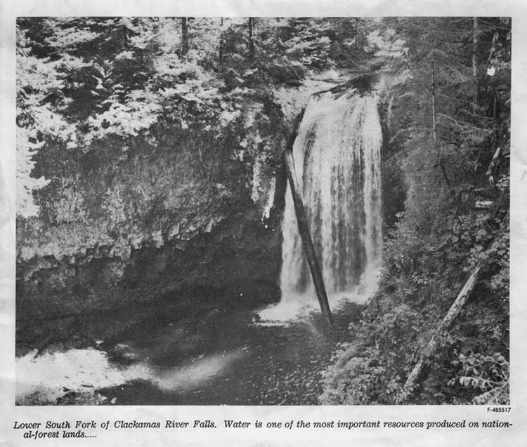
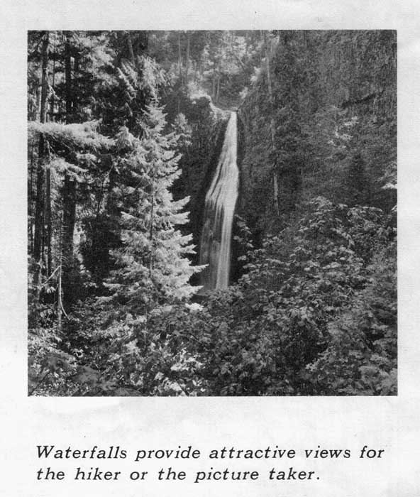
    If you missed the earlier discussion about the waterfalls, here are two links to old USFS photos of the lower and main waterfalls on the South Fork:

    http://www.splintercat.org/PortlandHikers/LowerSouthForkClackFalls1963.jpg

    http://www.splintercat.org/PortlandHikers/MainSouthForkClackFalls1959.jpg

    Here is Pete's description of the canyon:

    http://oregonpaddling.northwest-rivers.com/sf-clackamas.htm

    And here's the link to the Oregon Kayaking account:

    http://www.oregonkayaking.net/rivers/sf_clack/sf_clack.html

    Every time I read through these accounts, it strikes me that the old waterline route would be a very cool trail corridor - maybe someday we'll have a "pipes to trails" initiative, who knows?

    Tom
    South Fork Clackamas History
  • Re: South Fork Clackamas History (#)
  • There was a footbridge upstream from the confluence about a third of the way to the current bridge. The pyramidal footings are still visible on the south bank. Initially, the Watermaster lived in a house across the river where the vinca grows.  There was also a bunkhouse. A small concrete pad remains of the chlorine house. The pipeline is buried at this point. The house was an English Cottage craftsman period house. I have been told that there was a pontoon bridge at one time. At other times the equipment was  simply driven across the river at low water.
    The road is on the west bank and there was also a trail down from a church camp above. There remains a bridge at the Memaloose confluence. The South Fork line came first. The Memaloose collector came second. In the middle forties preparations were made for a higher intake above the falls on the Memaloose. This is when the tunnel on that side was blasted. It was never used as this upper intake was not completed.
    Later, the Watermaster lived on the highway side beside the railroad tracks on the bend at the beginning of Big Cliff. In 1937 the tracks were salvaged and a road was established. The Watermaster tended the pipeline along the river, swept leaves off the intake screens, attended the chlorine, and patrolled the system for trespassers. Parts of the pipeline trail are visible downtream on the opposite bank. Some pipeline is still visible at the upper North Fork pool. Easy to see in the Winter.
    I believe I was told it was vacated in 1961, perhaps in conjunction with North Fork Dam being built.
    The sections now belong to the BLM.
    I believe the cleared bench was one of the numbered camps associated with building the railroad/Oak Grove Project.
    • Re: South Fork Clackamas History (#)
    • Wow - great history, Donovan! I do hope you're going to put more of this into print someday. You're an incredible store of knowledge!

      Given that all of this was associated with a water works, I think I'll look around for photos of the structures you've described - there's a good chance of finding them, given the purpose. When you described the "bench" in the last sentence, do you mean the cleared area below Big Cliff, between the highway and the river?

      Tom
      • Re: South Fork Clackamas History (#)
      • One of my favorite areas with all the history and beautiful waterfalls.

        I did get to Memaloose Cr. the first time by just bushwacking from Memaloose Rd. I came in right above the waterfall (I've got a good nose for waterfalls I guess). I came out down by the main Clackamas and don't remember it being too bad. I had a friend that tried to go downstream along the bank from Memaloose bridge and got a really bad case of poison oak.

        In subsequent trips, I've just waded across the river. At low summer flows this isn't all that bad. Just under waist deep.

        pete
        • Re: South Fork Clackamas History (#)
        • Thanks for the info on fording the Clackamas, Pete. My main interest is in photographing whatever I can hike to, so now I'm thinking that a dry October would be a good time to wade the river and maybe have some nice color along the stream. I'm a little creeped out by the tunnels, but it sounds like everthing except the big tunnel by the "main" falls is short enough to see from one end to the other... I hope... (gulp!)

          Tom
          • Re: South Fork Clackamas History (#)
          • Yep, although there is one before the long tunnel which helps to have a little light for your footing. Just watch your step in the big tunnel as the old wooden walkway is pretty bad in places. It isn't too bad with light. My first time up was without a light and that was very creepy.

            Just an FYI, the Clackamas is running pretty low this year due to a dry spring so river levels will probably be a month early most of the summer. By that I mean that river flow right now is similar to what the flow would be at the end of June in a normal year. I think it is nice to get up to the waterfalls when they still have a bit of water in them. Although the fall color is a good time too.

            pete
            • Re: South Fork Clackamas History (#)
            • Yeah, I know what you mean about the river levels. I'm taking a group up Henline Creek next weekend to visit the upper waterfalls, and the Little North Fork gauge looks like flows that you'd see in early July. Right now I'm keeping my fingers crossed that the Rose Festival will usher in several weeks of steady June rain, right on schedule...

              One more question, Pete -- does this photo look like a view of the main (largest) falls on the South Fork from the trips that you've taken?

              http://www.splintercat.org/PortlandHikers/MainSouthForkClackFalls1959.jpg

              I've speculated that this is the South Fork, partly from feedback from Bryan Swan, and partly based on Donovan's photo of the base of the main falls that he posted here awhile ago. This photo is from an early 60s USFS map, I think. If so, was this taken from the vicinity of the rotten pipeline trestle described in the Oregon Kayaking report? That will most certainly be MY turnaround point..!

              Thanks for the info on this area, Pete - much appreciated!

              Tom
              • Re: South Fork Clackamas History (#)
              • Yes, that's the big one. There is a view before you get to the longest tunnel. It is also possible to get down to river-level at the base of the falls.