Manila Discussion archive for:
  • Rimrock Trail 704 - Clackamas Viewpoint

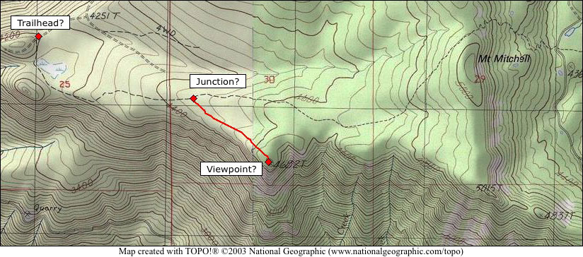
    I'm looking for info that anyone here might have on the Rimrock Trail over Mt. Mitchell. I haven't hiked it, but have seen the east trailhead while exploring the Cottonwood Meadows area. I've also read the USFS info sheet, and was hoping to get some feedback on my speculative map, based on the trail log on the USFS sheet:

    http://www.splintercat.org/PortlandHikers/RimrockTrailMap.jpg

    My questions are noted on this map - specifically (1) am I in the right spot for the West trailhead, (2) am I in the right vicinity for the junction with the viewpoint trail, and (3) am I even close to the actual alignment of the viewpoint spur trail? A related question is whether the USGS location for the Rimrock Trail is relatively accurate - I'm always suspicious when getting into provisional mapping, which covers the east part of the trail.

    This is on my "must visit" list for this year, and I'll collect waypoints and create a proper map once I have a chance to get up there. I might scout around for that connection between Hideaway Lake and Cache Meadow while I'm there, too, and collect some waypoints. After the mosquitos has cleared, though!

    Tom
    Rimrock Trail 704 - Clackamas Viewpoint
  • Re: Rimrock Trail 704 - Clackamas Viewpoint (#)
  • The west trailhead is correct. The junction to the viewpoint is wrong.  It is a mile east, near the section line between 29 and 30. The viewpoint is at the 5015 benchmark. There is another faint side trail to an old helipad above "Good Spring". The bugs were not out last week when we cleared the west end of the trail, but the snow lay in at about a mile and a half.
    The current District map has the west trailhead in the wrong place. There is no sign but the trail is easy to see.  There is a small pullout and a fire ring at the trailhead. If there is too much water at the "lake", there is a "bridge" 100' downstream.
    • Re: Rimrock Trail 704 - Clackamas Viewpoint (#)
    • Thanks for the info, Donovan - great to learn that the viewpoint is at the "true" summit, at least as defined by the rim! I've always wanted to be up there, and was disappointed when the USFS fact sheet mileages seemed to point to a different high point.

      I've always been surprised that the 5015 summit wasn't a roaded lookout site, given the proxmity to the road to Frazier Mtn and the amount of terrain laid out to the south of Mt. Mitchell. I guess Oak Grove Butte covered that territory? This part of the Mt. Mitchell is geologically similar to Lookout Mountain, with a pretty large, raw fault scarp by Cascade standards. One of my favorite spots in the MHNF!

      Tom
      • Re: Rimrock Trail 704 - Clackamas Viewpoint (#)
      • I have been told that it was an occasional observation point. The men would clip the portable phone to the wire. The wire lays in the trail and is a stumbling hazard in few places but I believe it should be left alone regardless.
        It would be interesting to have a geologist explain the area. I have always been struck by the jog in the mainstem river from Indian Henry to Riverford. An area full of old slides and still actively cut by the river. It also interests me the sandstone so high on the Fish Creek Divide.
        I have also wondered if the staircasing of the Cottonwood Meadows was glacial.
        There is an old road up towards the true highpoint that the trail crosses below the crest coming from Cottonwood Meadows but I have not followed it. I was once told it is the road that leads north from the small pool that feeds top of the Cot Creek drainage. Have you noticed that Cot Creek is dry most of the year at the Oak Grove Fork?
        • Re: Rimrock Trail 704 - Clackamas Viewpoint (#)
        • I agree about the old wires - part of the forest history. My favorite trails have insulators and wires on them! It's amazing that they've lasted this long.

          Geology! That's what I was supposed to do for a living, before the early 80s recession intervened... so apologies in advance for a long reply! As far as available data, I've been waiting for the Oregon geologic mapping project to be completed for years - the Cascades geologic topos will come online in 2009. At that point, it will be a bit easier to figure out the specific formations present in this area.

          But I'd agree with your speculation that the Cottonwood terraces are glacial -- based on a simlar elevation to the classic cirques that hold Hideaway, Shellrock, Rock Lakes, Serene and Shining lakes. A southeast-facing slope would typically produce a shallower, slower-moving ice sheet, and that would explain the shallower, less prounced cirque at Cottonwood Meadows. But the fact that you have depressions there, at all, is a pretty strong indication that a small glacier once filled this little valley. The steepness of Cot Creek as a glacial outlet is also pretty typical.

          A somewhat sketchier speculation is that Frazier Mountain was approximately the crest of a shield volcano that would be typical of the Old (or Western) Cascades volcanics. Larch Mountain is the classic example, along with Wildcat Mountain, Salmon Butte, Squaw Mountain, Fish Creek Mountain and many others. So I look at the slope that extends below Grouse Point as a perched shoulder of the shield volcano, deeply eroded on the north side by glaciers, and uplifted on the south side to form an eroded scarp that is the north wall of the Clackamas.

          I've always assumed the fault to be the basis of the scarp that extends from at least Shellrock Creek to the North Fork Clackamas, and points beyond that are buried under debris. The presence of Columbia River flood basalts in the canyon is even more interesting - underlying the shield volcanos in many spots, I think -- I'd have to check the geologic maps to know if this sequence makes sense. But this is likely one of the spots where the basalts spilled over an ancestral Cascade Range, and into the ancestral Willamette Valley.

          The disappearance of Cot Creek in summer could also be an indication of faulting in the area, with a very deep water table created by porous rock structures below. Normally, that would also produce springs somewhere below, but that could be at river level, and difficult to detect.

          The Fish Creek Divide is a real mystery to me - especially sedimentary rock up there! I've not seen that before. There has definitely been enough uplift to put sedimentary stuff several thousand feet up (most of the Coast Range was created that way), though it's less common in the Cascades. Looking at the surrounding, relatively intact volcanics in that part of the range, my guess would be that Fish Creek Divide is primarily an uplift mass, and sedimentary rock would be a pretty nice indication of that.

          The other area that is puzzling are Signal Buttes, Hambone Butte, High Rock and Wolf Peak. I'd classify these as part of an Early High Cascades volcanic formation - basically, the generation before today's high peaks. I'm pretty sure they all have dacite and andesite in their composition, though I'll have to check the maps to see if that's possible.

          Okay... I'd better stop before I lose my posting privileges here...

          Tom :-)
          • Re: Rimrock Trail 704 - Clackamas Viewpoint (#)
          • I was kinda wondering if Fish Creek Divide had some Eagle Creek Formation in it. I had thought the Frazier/Grouse/Mitchell slope was about uplift.
            I am also fascinated by SiSi after seeing from the air. A picture perfect caldera.
            Maybe you can answer why the granite references Granite Peaks and Burnt Granite? All I recollect is the ubiquitous rhyolite/andesite.
            • Re: Rimrock Trail 704 - Clackamas Viewpoint (#)
            • That's quite possible - at least that whatever sedimentary stuff you saw up on Fish Creek Divide is volanic in origin. The Eagle Creek Formation is really old, and a remnant of volcanics that are so far into the geologic records as to be pretty much unrecognizable now. The theory is that they came from stratovolcanoes that pre-dated the modern Cascade Range. That could be true for Fish Creek Divide, as well. If the deposits have angular or roughly rounded cobbles, then it's a pretty good guess that they are volcanic sediments along the lines of Eagle Creek Formation. The stuff usually doesn't cleave like sandstone, due to the range of material in the matrix, so that's another sign that you're looking at something different. Now my curiousity is going to drive me to find that geologic quad..!

              I've wondered the same about the Granite Peaks - again, I haven't poked around in the rocks there, but some andesite and especially dacite can contain fairly large crystals of feldspar or other minerals, depending on how slowly they formed -- and can be quite light in color, overall. So I've assumed that somebody saw some glints in an outcrop of white rock, and figured they were looking at granite.

              I looked at Sisi (again!) after your post, and that theory is very intriguing! It could easily be a caldera, given the youth of the various cones and domes in that area. Just looking at the contours, it looks like the exposed plug could be the result of some glacial action just below the summit area that followed a collapse or lateral (like St. Helens) blast. Interesting! As we've learned with the Crater Glacier at St. Helens, it takes very little time for a new glacier to form in a crater or caldera -- and the Crater Glacier has shown surprising defiance toward all the superheated rock popping up there. Geologists used to think that it took centures for a glacier that sizes to form on a stratovolcano!

              Always more to learn as the landscape evolves around us..!

              Tom
                • Re: Rimrock Trail 704 - Clackamas Viewpoint (#)
                • Thanks, Donovan - I could stare at this stuff all day! I hadn't found this site before - I've been watching another site, which is mapping at the 7.5 minute quad level:

                  http://www.oregongeology.com/sub/ogdc/index.htm

                  Rolling out very slowly!

                  Browsing around on the map you linked to sort of reinforced some of our suspicions, though I'm disappointed that there isn't better fault mapping along the middle Clackamas -- at least, nothing that directly addresses the big scarp on Mt. Mitchell. Also, no marine/estuarine sedimentary rock, though that might show up on a larger scale map. There are some alluvial formations east of Fish Creek Divide, and a couple of spots along the divide that show up as alluvial, so that could be your sandstone/Eagle Creek formation in that area. The "Granite" peaks show up as plain 'ol andesite and basalt, so no intesting suprises there.

                  Interesting that the upper reaches of the Collowash are dacitic. That should show up as bright gray or light rock, and makes for pretty stream scenes. I'll have to poke around down there next time I'm in the vicinity, and take a closer look.

                  Tom
      • Re: Rimrock Trail 704 - Clackamas Viewpoint (#)
      • Tom,
        There is a mistake in the ROG(info sheet). Thank you for catching it. Should be junction at mile 2 rather than 1.
        I will try to get it corrected in the new ROGs.