
Key Stats for Fish Lake Trail - 717
About
The info sheet contains a very detailed trail log. All that we could add is that the trail from the powerlines to Fish Lake has been abused and turned into a four wheel drive road by disrespectful visitors. Barriers have been created to limit this activity. You will need to climb over or walk around them. Other than that, the trail is a good one. Most used from the Olallie end. Was part of the Oregon Skyline Trail in the 1940s.
If you want to hike this from the west end, please be aware that there is a washout on the 4691-210 spur road at Squirrel Creek. It is passable for high clearance vehicles, but passenger cars won’t be able to get past this. If you can’t pass the washout, it is less than a mile to the trailhead from the washout.
Directions
Northern Trailhead:Travel Hwy 224 thru Estacada to Ripplebrook. Continue thru Ripplebrook and immediately after crossing the river, continue straight on Forest Road 46. Travel approximately 21.5 miles on Road 46 to Forest Road 4690 – there may be a sign here indicating a turn to Olallie Lake. Turn left on Road 4690 and travel approximately 3.4 miles to Forest Road 4691. Turn right onto Road 4691 and travel approximately 1.5 miles to Forest Road 4691-120. Turn right on Road 4691-120 and travel approximately 1.2 miles to the trailhead on the right. There is most likely no sign but there is space to park across from the trailhead.
Southern Trailhead:Travel Hwy 224 thru Estacada to Ripplebrook. Continue thru Ripplebrook and immediately after crossing the river, continue straight on Forest Road 46. Travel approximately 21.5 miles on Road 46 to Forest Road 4690 – there may be a sign here indicating a turn to Olallie Lake. Turn left on Road 4690 and travel approximately 8 miles to Forest Road 4220. Turn right on Road 4220 and travel approximately 4.4 miles to the Lower Lake Campground. Turn right into the campground – the trail leaves from the north side of the campground.
Map and Elevation Profile
Trip Reports
| Photo | Date | Report Summary |
|---|---|---|
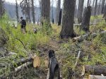 |
Sep 6, 2025 |
Post Fire Conditions
Hiked this trail from the north end on the 4691-120 spur. The washout at Squirrel Creek has gotten a lot worse. It definitely needs a high clearance vehicle to pass it now. The access point on the powerline road (the end of 4691) has had work done to it. There were several cars parked there so that might be a better access point from the north....
|