
We are officially in the heart of the summer hiking season, and the conditions couldn’t be better. All trailheads are completely accessible with zero snow remaining.
Please note that with the arrival of hot, dry July weather, public use fire restrictions went into effect on July 1st. Campfires, charcoal grills, and open flames are banned to prevent human-caused wildfires. Portable cooking stoves fueled by propane remain permitted. Thank you for doing your part to protect the trails we love while enjoying the prime summer conditions!
- All roads closed after the 2020 fires have been reopened, except for road 54 (Fish Creek).
- Hazard tree remediation on road 54 is ongoing – hopefully the road will re-open sometime this year.
Trail of the Month
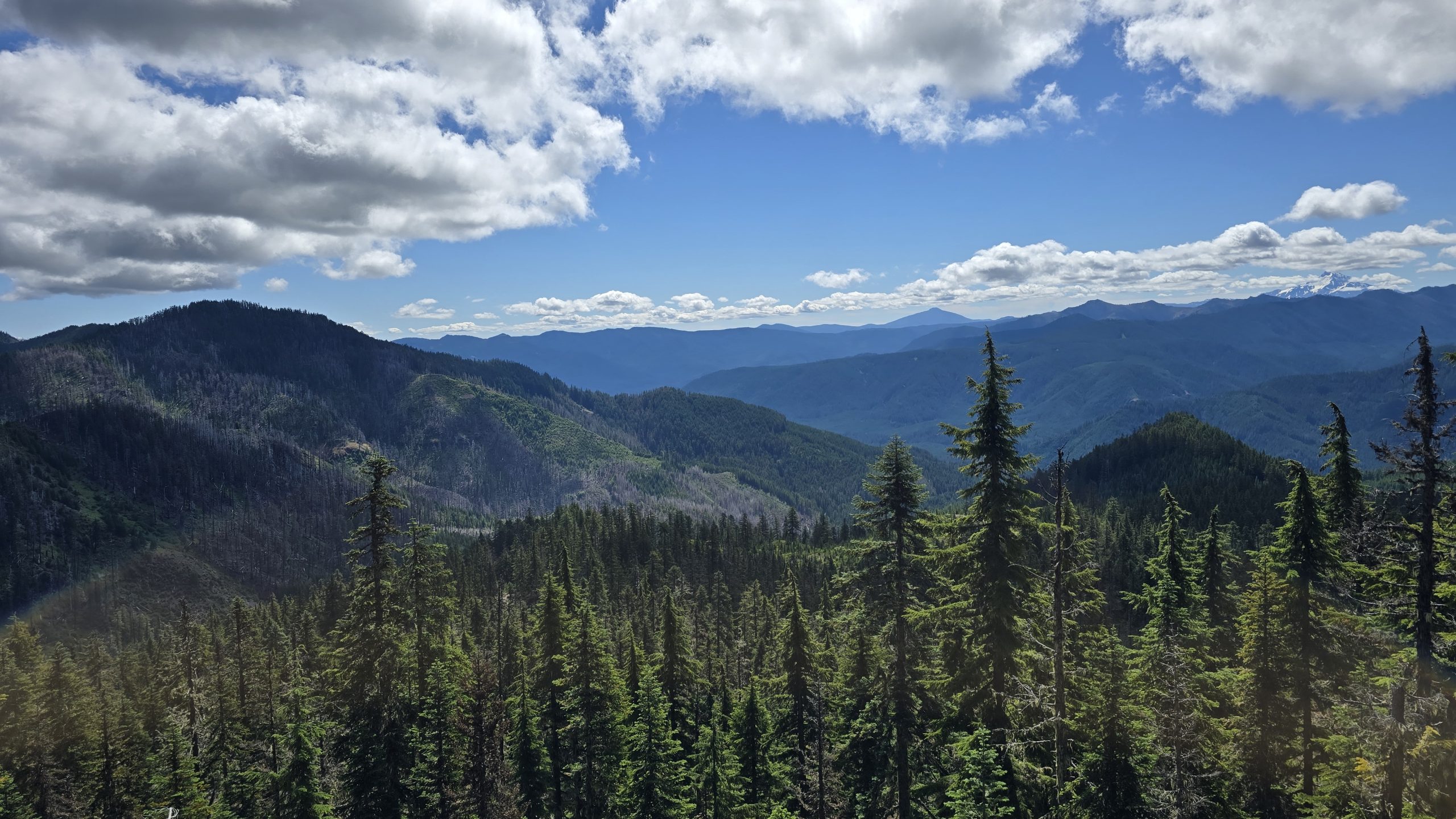
For July, we’re exploring Baty Butte, an ancient ridge-top trail that runs along the divide between the Molalla and Clackamas drainages. Though technically abandoned, the trail remains passable thanks to the hard work of volunteers. It’s a fantastic summer hike, offering beautiful views, abundant wildflowers, plenty of wildlife signs, and a welcome, refreshing breeze. Please note: There is a particularly challenging section about 2.5 miles from the north trailhead. The trail plunges into a steep descent where a massive tangle of over 30 uprooted trees blocks the path. To get past it, you’ll take a short, steep re-route that climbs just above the top of a huge rootball. Once you step back onto the main trail, conditions return to normal. If you want to be cautious, this dramatic blowdown site makes an excellent turnaround point.
🗺️ Explore Trail & Fire Impact Map
Some trails have had work done on them to repair fire damage, others have not. There are 64 Trails on this site and 43 of them have been affected by the fires. See the section below for known post-fire statuses.
Individual Trail Post Fire Status Updates
- The Alder Flat Trail has had significant restoration work done to it.
- The Battle Ax Creek Trail – Status unknown.
- The Bull of the Woods Trail trail suffered damage but is still hikeable and reasonably easy to follow.
- The Clackamas River Trail is currently being worked on. More work has been done on the Indian Henry end. There are still very difficult sections to navigate (washed out, slide areas, heavy brush, etc)
- The Cripple Creek Trail has had significant restoration work done to it but is challenging to follow in areas due to brush and downed logs up higher. The poison oak in the rockslide near the beginning is almost impossible to avoid – the poison oak is chest high now.
- Dickey Creek Trail – Fire Damage starts after creek crossing. Some work has been done but there are areas that are very brushy and difficult to follow past the creek crossing.
- The Dickey Lake Trail suffered considerable damage and has a lot of down brush and logs making it very difficult to follow. There appears to have been no work done on the trail since the fires.
- The Double Peaks Trail has been obliterated by the fire and will need to be rebuilt.
- The Dry Ridge Trail trail suffered damage but is mostly hikeable. The lower segments that were burned can be difficult to follow due to brush – especially in spring and summer. There has been some work done on the trail since the fires.
- The Elk Lake Creek Trail had work done on it last year but portions are still difficult to follow and brushy.
- The Fish Creek Mountain Trail has had considerable work done on it – As of May 2026 the entire trail has been cleared and is easily hikeable.
- The Fish Lake Trail has had work done on it – parts of it did not burn but the burned areas have had some logs cleared and brushed out.
- The Geronimo Trail – Status unknown – Trail has been affected by multiple rounds of fire.
- The Gibson Lake Trail – Sept 2025 – Signed on the PCT side, but is virtually invisible at that point due to the fire. Mid-section it is in decent condition, Warm Springs side it is still visible though looks like it needs some love.
- The Gold Creek Trail – Status unknown although there have been reports that at the junction with the Whetstone mountain trail there was no evidence of trail. Extreme caution advised if attempting to hike this trail.
- The Hawk Mountain Trail has had work done and is reasonably easy to follow.
- The Hillockburn Trail suffered significant damage and portions are difficult to follow due to brush.
- The Horseshoe Saddle Trail suffered significant damage and portions are difficult to follow due to debris on the trail.
- The Lodgepole Trail has had work done on it – parts of it did not burn but the burned areas have had some logs cleared and brushed out.
- The Memaloose Lake Trail suffered significant damage but has had significant work done on it and is reasonably easy to follow, including the trail up to South Fork Mountain.
- The Mon-Olallie Trail – August 2025 – Very good condition – no logs, good views, dusty with a slight amount of small brush trying to encroach.
- The Monon Lake Trail – August 2025 – Fair condition – moderate brush encroachment, a few logs.
- The Mother Lode Trail has had significant restoration work done to it.
- The Olallie Butte Trail – November 2025 – Good condition.
- The Olallie Lake Trail – August 2025 – Mostly very good condition – moderate brush encroachment in the burnt area, the short segment between the original Peninsula group campsite and Camp Ten was brushed out but had a couple of logs across the trail.
- The Pansy Lake Trail suffered damage but has had work done on it and is reasonably easy to follow.
- The Pacific Crest Trail – Affected areas are in the south end of the district. Trail has had significant work to restore the route.
- The Potato Butte Trail suffered damage and is difficult to follow in places but is still hikeable.
- The Pyramid Butte Trail – The north end junction was badly damaged in the fires and is difficult to follow in places. The route from the south is a lot easier to follow. Once on the trail, the route going up the butte is somewhat faint but not too bad.
- The Red Lake Trail has had work to re-establish it after the fires although the area near Red Lake can be difficult to follow in places due to brush.
- The south end of the Rho Ridge Trail suffered damage and portions are difficult to follow due to brush, although work has been done to improve travel thru the burned areas.
- The west end of the Rimrock Trail suffered some damage however the damaged area was short. Past that the trail is in decent shape. As of late summer 2025 all logs have been cut out from the western trailhead to the overlook trail junction.
- The Riverside Trail has been re-opened after many repairs and a lot of clearing. Over 600 logs have been cut off this trail! Recent work continues to repair damage from the December storms.
- The Ruddy Hill Trail suffered significant damage and is difficult to follow in places due to debris (mostly dead bark) obscuring the trail.
- The Schreiner Trail suffered significant damage and is difficult to follow in places.
- The Skookum Lake Trail suffered damage in places but has had work to restore it and is reasonably easy to follow.
- The Thunder Mountain Trail suffered minor damage in places but is easy to follow.
- The Timber Lake Trail – Status unknown.
- The Top Lake Trail – Status unknown.
- The Twin Lakes Trail – Trail crews logged out some of this trail last year (2025), but the status of the route is unknown beyond that. Assuming it is followable due to the work last year.
- The Welcome Lakes Trail – Status unknown but this trail has been affected by multiple rounds of fire and has not had any work done to it. Expect lots of downed trees and vague tread.
- The West Lake Way Trail – Status unknown.
- The Whetstone Mountain Trail suffered significant damage and is difficult to follow due to brush. It was supposed to have work done in 2024 but it was cancelled due to the Sandstone fire. Work has been done lower down on the trail, but towards the summit it is difficult to follow due to downed logs and brush.
Recent Trip Reports
- Bull of the Woods – Fantastic views of Mt Hood, Pansy Mountain, and Bull of the Woods
- Rimrock – Road to western trailhead is getting pretty rough - Trail is still beautiful
- Baty Butte – North end in pretty good shape - Significant blowdown in the middle
- Pansy Lake – Trail in good shape - Dickey Lake not so much
- Clackamas River – Rough trail conditions
The casual hiker going through an area doesn’t have the recognition of those who have worked on a particular trail through the seasons, or a 100 yard stretch of trail that took 3 workers all day to correct. Find a trail and make a difference. That is what a Trail Advocate does.
Make a difference! EVERYONE can be a Trail Advocate!
Trail maintenance doesn’t have to be complicated or difficult. Here are some simple ways everyone can help maintain and improve our trails:
- Throwing limbs, rocks, etc off the trail tread while you are hiking.
- Bringing hand pruners or loppers and clearing brushy areas.
- Flagging obscure sections of trail so others can follow easier.
- Reporting conditions to the Forest Service.
- For more ways you can help, see this page.
If everyone does just a little bit, it will make a HUGE difference in the condition of our trails.
Get InvolvedIf you want to be able to access some of the more obscure trails in our district, please make sure your voice is heard!
Please report ATV and/or motorcycle use of hiking trails to the Forest Service to help make them aware of the illegal abuse of our trails.
Environmental groups will not protect your trails. They often work against them and do pitiful little to mitigate the negative impact on trails their agenda wreaks. Even Oregon’s leading and otherwise venerable hiking club is not protecting your trails. It’s up to you.
Expect sudden changes in weather up high. High evening winds in the Clackamas Gorge. Watch for rocks on Hwy 224 in the mornings.
PLEASE don’t remove plastic flagging, it is probably important. Don’t be a hero. You could ruin someone’s years of research or get someone lost.
⚠️ CONDITIONS
Hiking in the Clackamas District is generally not like taking a walk in the Gorge or on Mount Hood. Our District is rough, steep, remote, and unforgiving. The trails are often faint, there are few signs, and help is far away. It’s wilder than wilderness. Don’t underestimate it. Be prepared. Cell phones cannot be relied upon.
DO NOT rely on internet trip planners to navigate the woods. DO NOT try to cross the District during the Winter, late Fall, or early Spring unless you know exactly what you are doing and have your Common Sense pulled up tight. Use Highway 26 or 22. That’s what they’re for.
There have been more unusual COUGAR ENCOUNTERS in the region so please be careful. Cougars have not been hunted with help from dogs for some time and are becoming impudent. Their habits are changing with respect to humans. Watch behind you from time to time. Cougars do not like to think you know they are following. When sitting, oppose one another and watch each others back. Cougars are attracted to sitting figures because they appear to them to be manageable prey. When a cougar advances on you, DO NOT RUN, assault the cougar with anything you’ve got. They are averse to being injured. A side arm is a prudent companion in the woods. Young cougars can work in pairs and are particularly stupid. Cougars like thick cover with a thin tree canopy.
You can call 503 261 9246, then 3-2, to hear the mountain WEATHER FORECAST (National Weather Service), or view the pinpoint forecast on any of the trail information pages. There is also a page dedicated to weather information, including links to weather stations around the district as well as a live webcam display from the Ripplebrook Store. The maps have also had weather and Snotel stations added to them, where current conditions and forecasts can be easily accessed.
Please encourage your ATV riding friends to respect our hiking trails by staying off of them. Point out to them that ATV damage to trails, vegetation, and water quality will likely lead to more restrictions.
🛣️ ROADS
- WATCH FOR LOG TRUCKS! There are thinning and fire recovery projects active in the Forest.
- Headlights are always a good idea in the woods.
- Keep right on outside curves.
- Please be very cautious driving our forest roads. There have been some serious accidents.
- Tricky curve on Road 57 at the bridge between the end of 224 and the Oak Grove Fork crossing.
- First 3 miles of road 45 from 224 remain closed. It does not appear this will reopen anytime soon.
- Road 7010 has a SLUMP difficult for cars to traverse about seven miles up.
- 4610 Road (the Abbot Road) has been improved after the Riverside fire to be used as a firebreak – the old washout between the old 790 trailhead and the 791 Salmon Butte trailhead has been repaired, although this should still be treated as a 4WD, high clearance route only.
🔒 SECURITY
It is surprising how many people leave valuables in their cars. Break-ins are common along the highway. Security at Bagby Hot Springs has improved greatly due to the new on site presence.
Enjoy the woods. Be safe and prepared.
🆘 EMERGENCIES
- Most loggers and equipment operators have radios for emergencies. PGE staff are very present along the Oak Grove Fork of the Clackamas River and have radios. Most Forest Service staff also have radios.
- Cell phones may work between SiSi and Olallie Butte. (Verizon).
- Cell phones may work at milepost 36 on Highway 224. (Verizon?).
- Cell phones may work at about milepost 2 (from Memaloose) on Road 45 at the corner with the guard rail. (Verizon? ATT?).
- Cell phones work on the 4610 road near High Rock (at the viewpoint to Mt Hood).
- Cell phones work at the dam at Timothy Lake. There is also reception at the powerlines on the 42 Road.
- In general Cell service in the district is improving and Cell phones may work in some of the higher elevations where you are on ridges, etc, but reception is still very spotty and cannot be relied upon for emergencies.
- In general Cell service will be non existent in river canyons and at lakes where you are in a bowl.
- Remember that even if you don’t have cell service, you may be able to send a text message. Text messages don’t require as much of a signal.
📋 WISH LIST
- Write us: webmaster@trailadvocate.org if interested in helping with adding or correcting content.
- An interpreter of celestial observation data from 1855 to determine points on the ground today.
- A bridge over the Roaring River at the Trail 517 crossing.
- A replacement of the shelter burned at Cache Meadow.