
Key Stats for Rimrock Trail - 704
About
The trail mileage for the Rimrock trail includes the overlook trail out and back.
Beyond the seasonal lake/meadow at the west end of the trail there is no water. Old maps show a spring called Good Spring near the view point junction at the top of the bluff to the south. An old side trail leads towards it on the right about a quarter mile west of the viewpoint trail. There are two orange spots painted at the base of two trees marking the junction. It is unknown whether the spring is year-round.
Viewpoint trail was Old 705 before numbering changes. The junction to the viewpoint is two miles from the west trailhead, not one as indicated in the info sheet at the link above. Connects at the east end with the Cottonwood Meadows Trail 705.
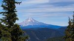
Mount Mitchell was named for Roy Mitchell who died fighting a forest fire August 20, 1919. The mountain was formerly called Oak Grove Mountain, an unsatisfactory name because there were no oak trees on the mountain and also the name caused confusion with Oak Grove Butte, seven miles to the south. Oak Grove Mountain had been applied because the feature was near Oak Grove Fork Clackamas River.1
This is an easy trail to hike. Be careful not to trip on the old phone line.
This trail has comments in the Old Posts discussion archive.
1Oregon Geographic Names, McArthur, Lewis.
Directions
West Trailhead: Travel Hwy 224 thru Estacada to Ripplebrook. Just past the Ripplebrook store, turn left on Forest Road 4631. Travel 4.1 miles to Forest Road 4635. Follow Forest Road 4635 for 7.5 miles to Forest Road 4635-140. Turn right on Forest Road 4635-140 and travel the the junction with Forest Road 4635-146. Travel .3 miles on road 4635-146 to the trailhead. There is a trail sign at the west trailhead.
East Trailhead: Travel Hwy 224 thru Estacada to Ripplebrook. Approximately 0.6 miles past Ripplebrook, turn left on Forest Road 57. Travel approximately 7.5 miles to Forest Road 58. Turn left on Forest Road 58 for 3 miles to Forest Road 5380. Turn left on Forest Road 5830 and travel approximately 7.7 miles to the trailhead. There is a small trail sign at the east trailhead. The Cottonwood Meadows trail is on the east side of the road. The Rimrock trail is on the west side of the road.
Map and Elevation Profile
Trip Reports
| Photo | Date | Report Summary |
|---|---|---|
 |
Jul 8, 2026 |
Road to western trailhead is getting pretty rough – Trail is still beautiful
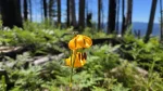
The 4635 road is getting pretty rough and brushy the further up you go. It also has pretty large potholes that have developed. Cars can still navigate the road but will need to be cautious. There are quite a few new downed logs in the burn area on the west end of the trail, but once you get thru that there are not too many downed logs until you ...
|
 |
Sep 16, 2016 |
Trail in great shape – a few logs but not bad at all
Trail in great shape – about 15 logs down from the west trailhead to the overlook junction and a couple more up the overlook trail. Almost all are easy stepovers – one is a duck under but not too bad. Trail is slightly brushy in a few areas, but not bad at all.
|