
Key Stats for Lodgepole Trail - 706
About
Route of the Pacific Crest Trail in the 1960s. Heavy horse use. Very rocky trail. Good description on USFS info sheet.
When coming from the north, the trail junction noted at .25 miles in the info sheet is a little confusing. It is not well marked. If you continue straight on the trail at this junction, you will be on the PCT. If you take a right at a sign that says “horse camp”, you will continue down the Lodgepole trail. The actual trail route differs significantly from the route shown on most maps. See the topo map below which has the actual route overlaid on it.
It appears as though the new USFS sheet says this trail starts at the Triangle Lake Horse camp, which is where some of the mileage difference comes from. The old USFS sheet (and the track) show it starting from the south end of the Olallie Meadows campground.
Directions
Travel Hwy 224 thru Estacada to Ripplebrook. Continue thru Ripplebrook and immediately after crossing the river, continue straight on Forest Road 46. Travel approximately 21.5 miles on Road 46 to Forest Road 4690 – there may be a sign here indicating a turn to Olallie Lake. Turn left on Road 4690 and travel approximately 8 miles to Forest Road 4220. Turn right on Road 4220 and travel approximately 1.4 miles to the Olallie Meadow campground. Turn left into the campground and follow the road to the south end. The trail takes off from the south end of the campground at the end of the road. There should be a sign.
Map and Elevation Profile
Trip Reports
| Photo | Date | Report Summary |
|---|---|---|
 |
Sep 6, 2025 |
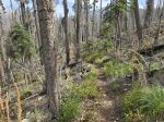
Post Fire Conditions
Hiked the south end - from Cornpatch Meadows to its terminus with the Red Lake trail. Trail had seen recent maintenance - cut logs. Overall was in pretty good shape - easy to follow.
|