
Key Stats for Red Lake Trail - 719
About
This trail is well described in the USFS Info Sheet. Pay close attention at the powerlines. Otherwise smooth sailing. Sure footedness required. Rocky from Sheep Lake to the PCT. A little brushy in places. This was an earlier route of the Skyline Trail.
Averill Lake was named for Ed Averill, who was a State Fish Protector for many years in the 1920’s.1
Nekbobets Lake south of of the Red Lake trail was named after World War II by a fish-planting crew. The name is a reversed combination of Ken, Bob, and Steve Koski, sons of Reino Koskim crew chief. The incorrect form Neknoberts was corrected by the USBGN in 1999 – many maps still show the incorrect form.1
1Oregon Geographic Names, McArthur, Lewis.
Directions
Western Trailhead:Travel Hwy 224 thru Estacada to Ripplebrook. Continue thru Ripplebrook and immediately after crossing the river, continue straight on Forest Service road 46. Travel approximately 30.6 miles on road 46 until you get to the Forest Road 46-380 spur – there may be a sign indicating where to turn for the Red Lake trail. Turn left onto Road 380 and travel approximately 1 mile to the trailhead on the left. There may be a sign.
Eastern Trailhead:Travel Hwy 224 thru Estacada to Ripplebrook. Continue thru Ripplebrook and immediately after crossing the river, continue straight on Forest Road 46. Travel approximately 21.5 miles on Road 46 to Forest Road 4690 – there may be a sign here indicating a turn to Olallie Lake. Turn left on Road 4690 and travel approximately 8 miles to Forest Road 4220. Turn right on Road 4220 and travel approximately 5.1 miles to the Olallie Lake Resort and Forest Road 4220-170. At this point, continue straight for another 0.3 miles to the Red Lake trailhead on your right. There is a sign.
Map and Elevation Profile
Trip Reports
| Photo | Date | Report Summary |
|---|---|---|
 |
Nov 15, 2025 |
Trail around Red Lake is rough – but the rest isn’t too bad
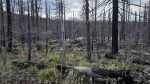
Hiked the full length of the Red Lake trail from the west end (off the 46-380 spur road). The beginning of the trail had obviously had quite a bit of work done on it after the fires. Most of the trail up to Red Lake was not too bad, even though it all burned pretty hot in there. Once on top near Red Lake, the trail is pretty rough for a bit. Th...
|
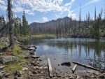 |
Sep 6, 2025 |
Post Fire Conditions
Hiked a portion of this trail - between the junction with the Lodgepole trail and the Potato Butte trail (Sheep Lake). Trail was in pretty good shape - portions did not burn but the areas that did burn were pretty easy to follow.
|