
Key Stats for Rho Creek Trail - 569
About
Trail is hard to find in places, little used, but quite scenic. Route climbs through several forest zones, from typical rain forest to arid lodgepole country, some sugar pine and yellow cedar in addition to the usual mix. Access to the stream and water in several places. Fairly easy to follow once found. Not recommended for the average hiker. Not recommended for solo trips. Do not take children on this trail. Cougar country.
Trail was first class when built. Very well graded. Intersects three other long abandoned trails.
Departs the 4671 road a mile or so south of 4670. Trailhead about a quarter mile north of Rho Creek crossing on the right in the straightaway before the curve to the right before the creek crossing. The initial part of the route has been logged. Blazes painted orange in this area. There is a Forest Service Trailhead marker. Park down at the creek and walk back up the road or there is a wide spot north of the trailhead. Nice camp at the creek.
Route is blazed. There is a switchback shortly after crossing Tumble Creek. Trail becomes much easier beyond this point. A half mile above Tumble Creek the route passes through a clearcut – the tread through here has been improved greatly and should be reasonably easy to follow until you get to tread on the other side of the cut. In another half mile cross a small bog and enter another small clearcut. Keep left along the edge of the harvest to Fadeaway Spring, then follow the switchback to the right up to the 4672 road. Trail continues across the road with a ramp slightly to the left.
From the 4672 road to the Rho Ridge Trail junction at the 4670 road the trail can be a bit difficult to follow in places but has had recent maintenance and has flagging. Turn right at the trail junction a mile above the 4672 road and emerge at a hunters’ camp (“Bear Camp”) off the 4670 Road about a half mile north of Graham Pass. Left at this junction leads to an old Guard Station site and on into the clearcut just north of Graham Pass. The Rho Ridge Trail can be reached by walking out of the hunter camp south to the main road. The 564 heading north is directly across the road at this point. There is a roughly cut, flagged route to connect the end of the tread to the Rho Ridge trail at an unmapped spur road just north of Graham Pass.
Trail is lightly maintained. Following it should be considered a cross-country adventure.
The meadows referred to in the USFS info sheet have grown in with Lodgepole Pine.
The Rho Ridge Trail is marked with yellow diamonds.
Directions
East Trailhead: Travel Hwy 224 thru Estacada to Ripplebrook. Continue thru Ripplebrook and drive approximately 16.5 miles to Forest Road 4670. Turn right on 4670 and drive approximately 1.5 miles to Forest Road 4671. Turn left on 4671 and drive approximately 1 mile to the trailhead on the right. There is a sign. There is a wide spot on the road to park a bit north of the trailhead.
West Trailhead: Travel Hwy 224 thru Estacada to Ripplebrook. Continue thru Ripplebrook and drive approximately 16.5 miles to Forest Road 4670. Turn right on 4670 and drive approximately 1.5 miles to Forest Road 4671. Turn left on 4671 and drive approximately 5.5 miles to Forest Road 4672. Turn right on 4672 and drive approximately 3.1 miles to the point where the trail crosses the road. There is no sign here, however there might be flagging on either side of the road. The road is wide enough to park and allow other vehicles to pass. Trail continues west up the hill, or east down to Fadeaway Springs and beyond.
Map and Elevation Profile
Trip Reports
| Photo | Date | Report Summary |
|---|---|---|
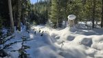 |
Jan 21, 2026 |
Cold but trail in great shape
It was 24 degrees when I started - cold but crisp. No real snow at the start. Snow mostly started where trail enters the old cut. From there up to Fadeaway springs the trail was covered and in some places pretty deep. The great news is that the first 2+ miles of the trail are clear of blowdown. There are only a half dozen past that and they ar...
|
 |
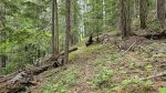
May 13, 2025 |
Trail continues to be in great shape
Trail had more recent maintenance including cutting out the large log mentioned in my trip report from 2024. There are 2 or 3 new small logs down but they are all easy stepovers. Above 4672 there are a couple new downed logs but those are also easy stepovers. Trail continues to be in really good shape.
|
 |
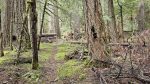
Aug 15, 2024 |
Trail in great shape
Trail had very recent maintenance on its whole length, both below the 4672 road as well as above the 4672 road. Tread work has been done in places and flagging was present above the 4672 road. The only log on the whole trail was a rather large one near the beginning, which was a reasonably easy crawl under.
|
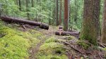 |
Jun 14, 2020 |
Recent maintenance but still needs work
I hiked this trail yesterday – the part between 4671 and 4672 has had recent maintenance and is in pretty good shape with a few difficult spots. The Tumble creek crossing is still a bit rough and there are a couple of new tree uproots which are somewhat tough to get around/over. Other than those, the trail is easy to follow.
Above 4672 there a...
|