
What trail am I on? Spring 2013 edition
D
Hmmm.
For some reason I am thinking Dry Ridge.
Don 2
Retired from Retirement and back to work.
R
Well, Dry Ridge is close, but not quite right.
D
Is that tree on the Rimrock Trail by chance?
Don
R
Donald Presley said Is that tree on the Rimrock Trail by chance? DonYou would be a little too far south.
B
How about 517 Cripple Creek - Grouse Point trail?
R
Bryon Boyce said How about 517 Cripple Creek - Grouse Point trail?Still too far south - one more clue - this is a lightly used trail.
D
Huxley Lake Trail?
Don
R
Donald Presley said Huxley Lake Trail? DonYou are getting warmer
D
The only other trail which we haven't mentioned would be the Corral Springs Trail!
Don
R
Donald Presley said The only other trail which we haven't mentioned would be the Corral Springs Trail! DonThere is at least one other trail (further north) that hasn't been mentioned. Or if it has, I missed it. Remember, this is a LIGHTLY used trail. VERY lightly.
D
That can't be the Old Baldy Trail?
Don
R
Donald Presley said That can't be the Old Baldy Trail? DonWell, I suppose it COULD be, but it is not. But you are on fire now. REALLY close! Remember, I said LIGHTLY used trail.
D
 You said it was a current trail in a new wilderness area. That leaves out the Fanton Trail for it is outside the wilderness boundary. The Old Bissell Trail is considered abandoned. So that only leaves the White Iris Trail and only part of it is in the wilderness boundary. I include a portion of our district map with new wilderness boundaries in green and trails marked in orange that I cleared a couple of years ago.
White Iris Trail?
Don
You said it was a current trail in a new wilderness area. That leaves out the Fanton Trail for it is outside the wilderness boundary. The Old Bissell Trail is considered abandoned. So that only leaves the White Iris Trail and only part of it is in the wilderness boundary. I include a portion of our district map with new wilderness boundaries in green and trails marked in orange that I cleared a couple of years ago.
White Iris Trail?
DonR
Donald Presley said You said it was a current trail in a new wilderness area. That leaves out the Fanton Trail for it is outside the wilderness boundary. The Old Bissell Trail is considered abandoned. So that only leaves the White Iris Trail and only part of it is in the wilderness boundary. I include a portion of our district map with new wilderness boundaries in green and trails marked in orange that I cleared a couple of years ago. White Iris Trail? DonVery well thought out answer, and you are correct. I believe (but am not positive) that this tree is in the wilderness area. It was a very interesting tree. It appears as though it broke partially (both the top and towards the base), which looks like it killed the tree, and then it became a nurse tree for another tree towards the top. Really interesting.... Your turn to post something!
D
 I have more time to think these days. A robin woke me up this morning singing his song outside my window at 8am. I could get used to this.
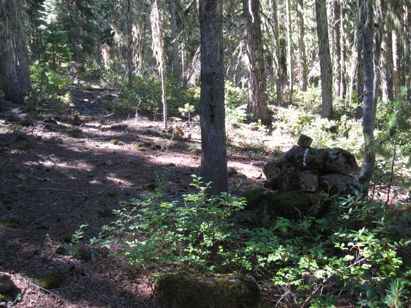
A trial photo to post! This photo is of an abandoned trail that isn't in a wilderness area, though this area is pretty much virgin forest. I took the photo because of this rock cairn next to the blazed tree. One of the rocks had pink & black flagging on it, so I am assuming that the USFS archaeologist has been here at one point. I couldn't find any reason for the rock cairn, for there wasn't a trail junction or section line in the area. Upon further investigation, I am thinking this marker maybe a county line marker for this county line does come through this area.
Don
I have more time to think these days. A robin woke me up this morning singing his song outside my window at 8am. I could get used to this.
A trial photo to post! This photo is of an abandoned trail that isn't in a wilderness area, though this area is pretty much virgin forest. I took the photo because of this rock cairn next to the blazed tree. One of the rocks had pink & black flagging on it, so I am assuming that the USFS archaeologist has been here at one point. I couldn't find any reason for the rock cairn, for there wasn't a trail junction or section line in the area. Upon further investigation, I am thinking this marker maybe a county line marker for this county line does come through this area.
DonD
Looks like Skyline country to me.
Don 2
D
Donovan said Looks like Skyline country to me. Don 2Your right, it does look like Skyline country, that's because it is. Any chance you may know where on the 100's of miles of this trail where that photo was taken? Of course, I am only counting on those sections that fall within the Clackamas district. Don
D
If it's where I think, it wasn't stacked quite like that. It was a rectangle and I thought it a child's grave.
Later I thought it may have been a cache, missing it's lid.
Now I simply don't know, but I do think it's at a junction.
Don 2
D
Don 2, I think the place along the Skyline Trail that your thinking about is at a trail junction and yes the rockpile is still in a rectangle and not far south of Lemiti Butte, but it isn't the place of the photo.
Don
D
Don 2, seeing how you've mentioned that the trail was the Skyline Trail or in the Skyline country your the lucky winner of a new posting of your choosing. The photo was taken of an abandoned section near a rock cairn about a mile north of the last road crossing between the Pinheads. I hiked out a little further, but it was pretty much the same type of terrain and forest, that rock cairn being the only notable landmark in the area to be seen. Looking forward to this summer, when I can get back out there and do some more exploring, of course once the mosquitoes quiet down a little.
Don
Log in to reply.