
Anyone been out in the district lately?
Originally posted on or around May 22, 2008
With all the hot weather, I'm wondering if any of the lower elevation trails (3000' or thereabouts) are accessible now. I've been monitoring the snow levels on the sno-tel site, and it appears to fluctuate quite a bit, even at stations that are at similar elevations. For example, Clackamas Lake, which is at 3400' shows 1-2" of snow, and Peavine Ridge, which is really close, and 3420', shows 29" of snow still. Or Marion Forks, which is only 2600' still has 35" of snow!So, I'm thinking possibly of exploring the Fanton Trail this weekend, which says it is 3100'-4100'. I'm just wondering if I will be wasting my time, or if the snow is gone enough to be able to enjoy part of the trail. I've hiked the upper portion of Fanton (up to Squaw Mtn I think), but never the lower portion....
Any insights are appreciated.
Thanks
Rob
Originally posted by Simon Harding on 5/22/08; 6:48:47 AM
Last Saturday I was up the Dry Ridge Trail. Was up it a mile or two the Wednesday before that. No snow. We did not go as far as the viewpoint. Did a bunch of tread work. Others have cleared the blowdown as high as we went. This trail is improving rapidly.We also went to the Milepost Three trail. The road is clear to the TH, and we went as high as the small creek at the top of the intial switchbacks through the rock fields. Just beyond the creek, you hit snow. But I am sure it has melted back a bit more. we hit only one blowdown and cleared it.
I am sure the Fanton Trail is at minimum in some patchy snow.
There's more and more opportunity for joining in the trail work as the snow melts back folks.
Originally posted by Rob Williams on 5/22/08; 7:27:32 AM
Milepost Three Trail? That doesn't ring any bells.....Is it an official trail? Where is the trailhead? Any other info on it? I'm always interested in hearing about new trails.I've only been up Dry Ridge twice, and never beyond the creek (when I went it was running pretty fast, and I didn't feel like taking a dip).
Thanks for the info.
Rob
Originally posted by Simon Harding on 5/22/08; 8:56:44 AM
It is up the 6435 road and the trailhead is vague and unflagged, at about milepost three. It goes up the hill. It is an abandoned /administrative trail I think. Unsure what, if any "official" name it has.Originally posted by Rob Williams on 5/22/08; 9:45:07 AM
Hmmm....Sounds interesting. Which side of the road is it on as you are going up? How long is it? Any other tidbits on it? Any interesting sights on it? (lakes, wetlands, summits, viewpoints, etc)Sorry for all the questions, but you have me intrigued...
Originally posted by Rob Williams on 5/22/08; 9:58:21 AM
6435? Or 4635?Originally posted by Karl Helser on 5/22/08; 8:11:54 PM
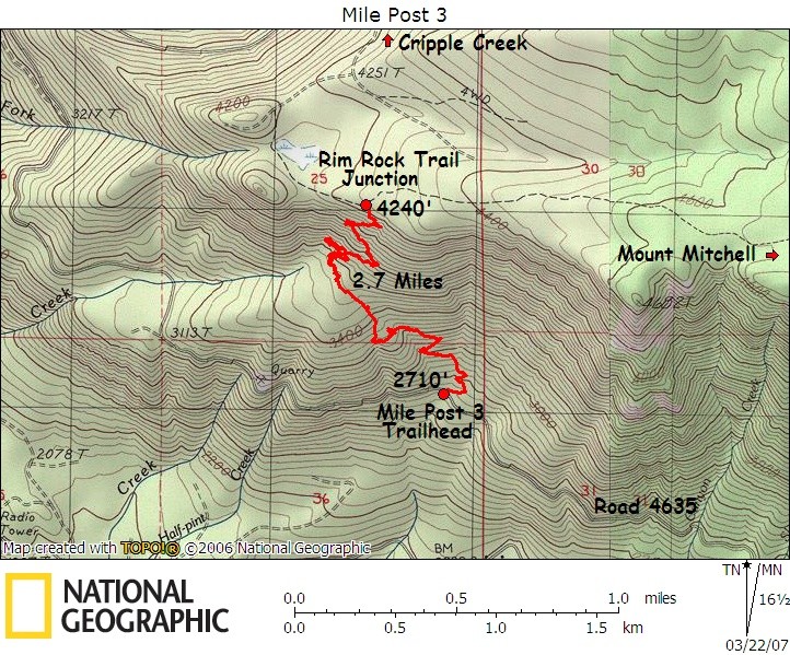
Road #4635... The UTM coordinates at the trailhead are 10T 577761mE 4994293mN The trail starts out at 2742' and tops out at 4256' in 2.7 miles where it T-bones the Rim Rock trail. Donovan took me up there once....Originally posted by Rob Williams on 5/23/08; 5:10:02 AM
Very cool! If the weather cooperates, maybe I'll try this one instead of Fanton....I LOVE the rimrock trail. One of my favorites. Beautiful area.Thanks for the detailed info!
Rob
Originally posted by Simon Harding on 5/23/08; 7:17:49 AM
Sorry for the dyslexic moment. 46. Not 64.It is a great trail.
Originally posted by Rob Williams on 5/23/08; 8:32:23 AM
No worries....My fingers get dyslexic sometimes too! Hopefully the weather will cooperate this weekend and I can get out and do a little exploring.Originally posted by Rob Williams on 5/24/08; 8:35:08 AM
OK, now I think I see where it is. Interestingly enough, based on the GPS coordinates that Karl posted, this trail appears to show in my Garmin MapSource software map, however it doesn't show the rimrock trail that it runs into, or the cripple creek trail. It does show the trailhead for Cripple Creek, just not the trail path. I also see the note on the rimrock trail sheet about this trail. I'm still hoping that the weather will improve sometime this weekend so I can try and explore this trail. Hopefully I can follow it....Does this picture look like the right area? This is where it shows up in my Garmin software:
Milepost 3 Trail Map?
Thanks again for the info. I love learning about all these "undiscovered/abandoned" trails out there. I'd love to be able to find one myself, but I guess my eyes just aren't trained as well as a lot of you. It sure is fun hiking through old forest history, though!
Rob
Originally posted by Rob Williams on 5/24/08; 8:40:11 AM
That was weird....The website kind of freaked out and posted my message twice.....Sorry!Originally posted by Donovan on 5/24/08; 10:25:50 PM
This the most accurate map of MP3 Trail.
Originally posted by Rob Williams on 5/25/08; 6:34:51 AM
Thanks for the map. I look forward to hiking this trail!What other little gems do any of you have hiding?
Rob
Originally posted by Paul Turner on 5/26/08; 8:46:13 PM
I did this today in a loop starting from MP3 trail upward to where the Rimrock Trail might have been on to Mt Mitchell then return via the 5830 Rd above Cottonwood Meadows and the trail along Cot Creek. I counted 6 stems across the MP3 trail - nothing too large but chain saw required. Right above the large talus slope was a spot where snow has laid brush across the trail and with no snow, the brush did not spring back - was hard to get through without getting soaked. The MP3 trail was mostly free of snow, I only had to head scratch a couple of times to figure out the trail through the snow. The upper part is snow free up until the intersection with the Rimrock Trail where the snow instantly went to about 4 feet and increased to maybe 10ft+ on Mt Mitchell. The snow was fairly consolidated and I did not snowshoe up until I got close to Mt Mitchell. I wanted to do the viewpoint but the whole area was socked in and raining most of the day so I'll have to catch it on another hike.
It was a great day, just missing some sunshine to make it perfect. I would class the MP3 trail as an old-growth hike as there were some substantial trees in the lower part (and clearly some substantial trail maintenance issues because of it). Also, from the MP3 trailhead looking south I swear I could detect a trail heading down the hill, I followed it for a bit - seemed like there was something there. From some maps I have there was supposedly a trail all the way down at one time.
I missed the upper part of the Cot Creek trail due to snow but ran into it about halfway down. There were a couple of stems across the trail and lots of branches - I tossed what I could. I need to revisit this one to catch the upper part.
Thanks to Rob Williams for starting this thread, Karl Helser for the UTM coords of the trailhead, they are spot on, and to Donovan Harding for the map. And of course a huge thanks to the volunteers keeping the MP3 and Cot Creek trail open.
--Paul
Paul Turner
Originally posted by Rob Williams on 5/27/08; 5:08:10 AM
Thanks for the report, Paul! I was going to do this trail this weekend, but wimped out due to the rain. I ended up cleaning up my shop and my office (ugh). At least I was productive....So now you bring up yet another "hidden" trail. I've heard of the cot creek trail before, but never seen any details of it. Care to post some details? (Trailhead location, trails it intersects, elevation(s), points of interest, etc). That sounds like another one I can add to my "to explore" list.
Thanks much!
Rob
Originally posted by Paul Turner on 5/27/08; 6:27:04 AM
I may have got the name wrong, it's a section of the #705 Cottonwood Meadows trail. There is/was a map of this I believe attached to the #705 description on this site but I either misremembered or forgot where the map is located. The trailhead from Skunk Creek road is easy to spot, there's flagging and a rock cairn.--Paul
Originally posted by Paul Turner on 5/27/08; 7:34:39 PM
I wasn't paying attention when I wrote up my reply to this post last night - the map is found following a link off the Cottonwood Meadows #705 trail description page right below the link to the USFS info sheet. Here's the link.There is another low elevation lost trail mentioned on this site I'm interested in locating. It's discussed in the April hike where there is the short segment going up the hill, "Starts at Highway 224 near the Roaring River climbing out of the canyon on a long abandoned trail to Winslow Pit on the 4611 road." I scouted the pullout just west of the RR bridge but didn't see anything obvious. I assume if there's a trail bench at all a person will run into eventually by just going up hill. BTW, this trail segment appears on the 1916 Estacada 30' topo and the 1938 MHNF map but is gone in the 1946 MHNF map.
Thx,
--Paul
Originally posted by Rob Williams on 5/27/08; 8:18:59 PM
So the trail you referred to as the cot creek trail is really the cottonwood meadows trail? That sounds like another interesting exploration to do...So does the other lost trail you reference...If you find out more about it, please post what you learn.Rob
Originally posted by Donovan on 5/28/08; 7:00:32 PM
Go west on 224 around the bend to the large pullout under the power lines. At the west corner of the clearing at a pile of boulders enter the woods and find the trail. Making the connection to the Huxley Lake Trail can be a bit of a puzzle.This topic is locked and no longer accepts replies.