
Snow Levels - 5/19/2012
R
I thought I would add a new topic since the date is almost a month later than the previous posting.
I took a trip up to do the Bissell and White Iris trails yesterday, and the roads were completely clear. I didn't see any snow at all until I hit north facing slopes, and then I ran into a couple of feet, but that was about 4000' plus. I think things are melting out pretty good this year. It looks like I was a little early for the white iris bloom on the white iris trail, though. I just saw the "stalks", no flowers. There were some skunk cabbage, trilliums and other assorted wildflowers starting to bloom, however.
R
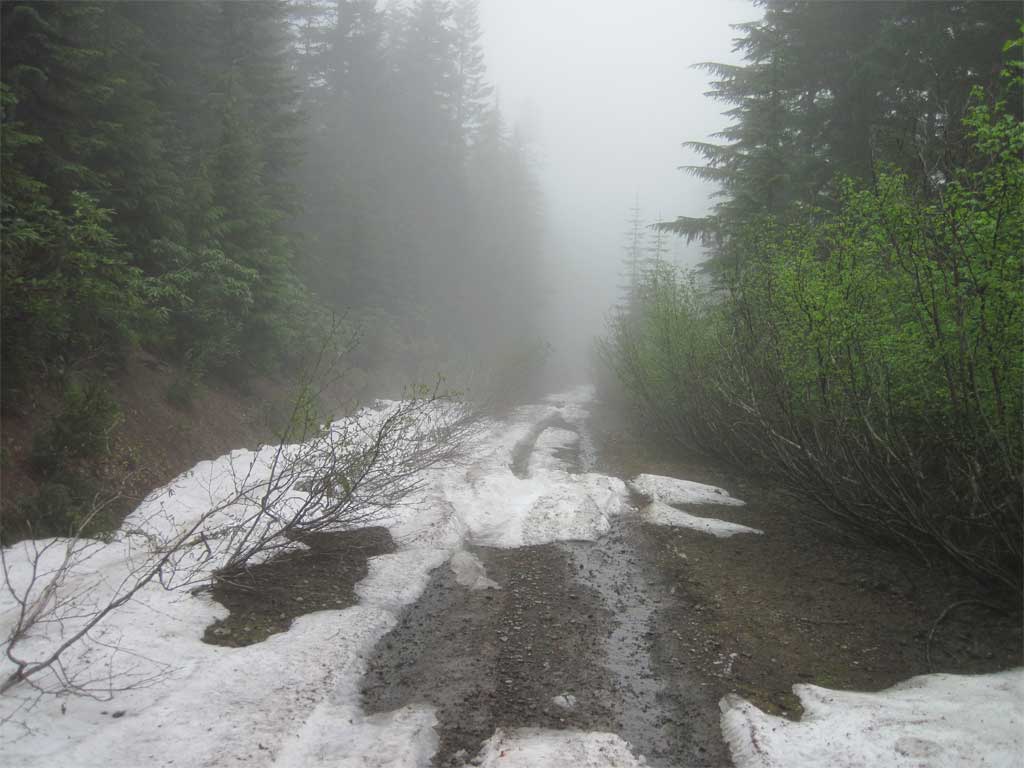
Patchy drifts at Cot Creek, 3800'. Bare southern exposure up to that point, very dry and crispy already...
R
Robert Koscik said Patchy drifts at Cot Creek, 3800'. Bare southern exposure up to that point, very dry and crispy already...So did you get to hook up with Don, and if so, what interesting things did you find?
R
Hmmm we found the bottom of a whiskey bottle! And a rough Sunday morning.
Nothing too exciting besides clearing the trail to the clearcut. It was pretty bad on top.
We are probably 1/2 mile from linking the two ends now. Once the snow melts I'd like to get back up there, but the swarms of mosquitoes scare me. But I'd bet that in 2-3 weeks the snow will be mostly gone at 4000' in the area. You'll have to join us for a camp trip.
D
Road 6350 going up to Graham Pass from the Collawash is blocked by snow at about 4000 feet elev., about one mile before the junction with Rd 4670.
R
NWS:...SNOW BELOW PASS LEVELS IN THE CASCADES TODAY INTO TONIGHT...

SNOW LEVELS HAVE LOWERED TO NEAR 4000 FEET THIS MORNING AND WILL
HOVER NEAR THAT LEVEL INTO TONIGHT. SEVERAL INCHES OF SNOW WILL
FALL ABOVE 5000 FEET TODAY INTO TONIGHT. ACCUMULATIONS WILL
GENERALLY REMAIN MINIMAL CLOSER TO 4000 FEET TODAY...BUT A SLUSHY INCH
OR TWO OF SNOW AT PASS LEVEL COULD BRIEFLY CREATE HAZARDOUS TRAVEL
CONDITIONS EARLY THIS MORNING AND THEN AGAIN THIS EVENING INTO
TONIGHT. OUTDOOR REREATIONISTS SHOULD ALSO BE PREPARED FOR WINTER-
LIKE WEATHER ACROSS THE HIGHER CASCADE MOUNTAINS DURING THIS TIME.
L
Anyone know if Elk Lake is accessible by road at this point? I'm planning to try it tomorrow and will report back this weekend.
I was blocked by deep snow at 3700 feet (right at the Opal Lake trailhead) on the 2207 road last weekend.
Mark
K
I don't know about Elk lake. But I heard that on Monday there was just a little bit of snow at 4,000' a few miles north of there at Hideaway Lake on road 5830. There was reportedly one snowpile blocking the road about a hundred yards from the Shellrock Lake trailhead. I'll be up there this weekend to check it out first hand.
L
Road is clear to within 200 feet of Elk Lake. Beyond that there are three one-foot-deep snowdrifts that have been breached by at least one vehicle. I would expect the road to be clear by next weekend especially with this warm weather. Parts of the road are very rocky and would be challenging in a vehicle with less clearance than a Subaru.
K
Made it up to Shellrock Lake Friday evening. 5830 is snow free to the trailhead. I heard from someone else that there was still quite a bit of snow in the Hidaway Lake Campground. I would estimate that the area around Shellrock is 99.9% free of snow. We tried trail #700 to the Rock Lakes via Frazier Turnaround today. But the snow cover up that way is probably close to 50% and up to 5' deep. We lost the trail about halfway up the hill and drifted too far east. Amazingly we hit Frazier dead on after our snowy cross country excursion. I knew we were getting close to the road when we found a baseball and an old tire coming up the hill.
Some of our group wasn't doing too well with all the snow, so we ate lunch at the picnic tables and returned to Shellrock. (We didn't lose the trail on the way down.) As we were headed back to Shellrock, we met a couple headed to Rock Lakes. Hopefully our tracks in the snow helped them get to Frazier at least. (We told them which set of tracks to follow.)
No vehicles have been up to Frazier yet. One of the groups at Shellrock said they had attempted driving to Frazier, but had been turned back by large amounts of snow.
The boys didn't get any fish at Shellrock, so we stopped at Harriet on the way home and they were successful there.
R
Did you find any remnants of that elusive side trail to Cache Meadow?
I wish I could have come.....Sounds like a fun weekend!
K
I didn't have much of an opportunity to look very far. I think I saw a blaze above the Shellrock trail headed up the ridge. It's just as described by Joe Keller, a few years back:
"It started in the trees near the clearcut between Hideaway and Shellrock Lakes, close to Shellrock Lake. It went up the ridge"
It may have been easier trying to follow that old trail than the snowy way we went. I'd like to explore that old trail someday.
R
Hi Kirk, do you think that the Cottonwood Meadows trailhead will be accessible by next week? It's only a mile or 2 further up from Hideaway. Maps show it over 4200' though.
Of course it could be mosquito hell already, we've had some hot days and lots of wet.
Want to get out and camp but may need a plan B.
K
From what I saw on the trail between Shellrock Lake and Frazier Turnaround, the snow level was about 4,500'. I'd give it a try. But like you said it would good to have a "Plan B".
The mosquitoes weren't bad when we were there, but they're probably getting hungrier with each passing day.
R
Thank you! Am also considering Anvil Lake but not sure if there's anywhere to camp over there.
J
kirk said I didn't have much of an opportunity to look very far. I think I saw a blaze above the Shellrock trail headed up the ridge. It's just as described by Joe Keller, a few years back: "It started in the trees near the clearcut between Hideaway and Shellrock Lakes, close to Shellrock Lake. It went up the ridge" It may have been easier trying to follow that old trail than the snowy way we went. I'd like to explore that old trail someday.I'd be up for recreating that walk again some day.
R
No snow at 4500' towards High Rock off 58. 10 bazilion mosquitoes though, more than I've ever seen. Clouds of them. Stay away from the meadows if you have any sense!!!!!!
P
I went up Abbott Road from 224 today and the road was snow free up until just about a mile before Twin Springs when it became, for me on a motorcycle, impassable. Will be another week, I think, before the road snow is all gone. Of course, it could be that Twin Springs is clear and the snow is limited to what I saw. The plan is to go back next Saturday and give the 506 a shot - if the weather cooperates.
--Paul
R
That looks like a little past Squaw Meadows? At any rate, it is good things are melting out.
I will be interested to see if you can continue the trail past the point where it meets the creek. We couldn't really find any trail past that point. It was very clear, easy to follow (even in the snow) until it hits the creek.
P
Rob Williams said That looks like a little past Squaw Meadows? At any rate, it is good things are melting out. I will be interested to see if you can continue the trail past the point where it meets the creek. We couldn't really find any trail past that point. It was very clear, easy to follow (even in the snow) until it hits the creek.Yes, past Squaw Meadows. BTW, thanks for posting your GPS track for the 506. The plan is to search for trail down to the river then back up and look for the 509. I plan to go upstream from there, trail or not, to where you guys came down for your Cougar Creek exploration and back up to the road. If I make good time and feel energetic I may go for the whole thing and come out at Hambone Springs - I'd love to travel that expanse of old-growth along the river - if not this trip, on another outing. --Paul
Log in to reply.