
What trail am I on - Part 3
R
Doug Firman said:
Doug, No, not Round Lake Trail, you need to go further east.
Rob, I am using Internet Explorer and still having problems with uploading photos. I don't use Firefox so can't give you a test of that. Don, Is that Round Lake and the Round Lake trail?
Doug, No, not Round Lake Trail, you need to go further east.
D
Since I am able to upload photos now, I am resubmitting this one under the right heading.
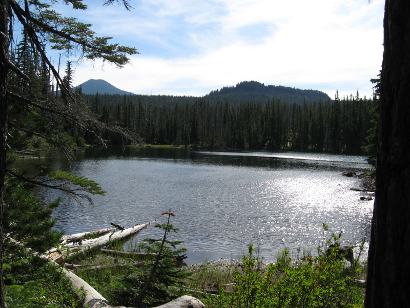 This is a current district trail not in a wilderness area. It is a through trail, for this lake is not the destination, but gives a nice view from the trail.
This is a current district trail not in a wilderness area. It is a through trail, for this lake is not the destination, but gives a nice view from the trail.R
Fish Lake?
D
Rob Williams said:
Right area, wrong lake.
Fish Lake?
Right area, wrong lake.
D
I think it's Averill lake on the Red Lake Trail.
D
Donovan said:
Right trail, wrong lake. Head up the trail a little ways. Do they still have grazing rights in these parts of the state? In some parts of eastern Oregon I think cattle are thicker than mosquitos. Then I have been in parts of this state when the moment was right when the local insect population was able to haul your ass out of the imediate area faster than you could on your accord.
I think it's Averill lake on the Red Lake Trail.
Right trail, wrong lake. Head up the trail a little ways. Do they still have grazing rights in these parts of the state? In some parts of eastern Oregon I think cattle are thicker than mosquitos. Then I have been in parts of this state when the moment was right when the local insect population was able to haul your ass out of the imediate area faster than you could on your accord.
R
Well, then it has to be either Wall or Sheep Lake. I'm guessing Wall Lake.
D
Rob Williams said:
It was actually Sheep Lake, with Olallie Butte and Twin Peaks in the background.That was why I was hinting at grazing rights in my post last night, hoping someone might make the connection to Sheep Lake. Seeing how you were the first to bring up the name, you can post the next photo.
Well, then it has to be either Wall or Sheep Lake. I'm guessing Wall Lake.
It was actually Sheep Lake, with Olallie Butte and Twin Peaks in the background.That was why I was hinting at grazing rights in my post last night, hoping someone might make the connection to Sheep Lake. Seeing how you were the first to bring up the name, you can post the next photo.
R
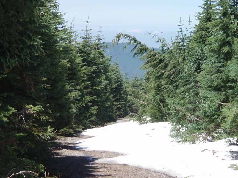
OK, here is another trail. It is on a current trail and is in a new wilderness area.
D
Is that the walk out Indian Ridge to Shining Lake?
R
Donovan said:
A little too far North. This particular section of the trail may not be officially maintained.
Is that the walk out Indian Ridge to Shining Lake?
A little too far North. This particular section of the trail may not be officially maintained.
D
Doug,
Your last photo posting for What Trail Am I on? got me thinking. I hadn't been on that trail, so I looked it up on our current district map. I noticed that the trail to Welcome Lakes had two different numbers, depending on which direction you came from. It was the #554 if you came from the east up from Elk Lake Creek, or #556 if you came from the west from Big Slide Mtn.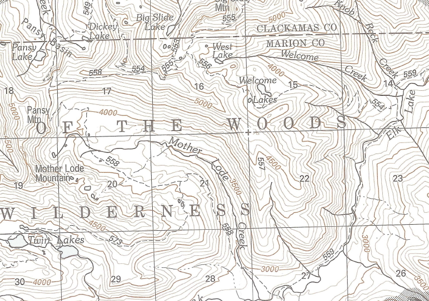 I thought that was odd, so I looked at my Green Trails Battle Ax map and it showed me the real picture. The west portion of the #554 had been taken off the map as well as the infamous Geronimo Trail that plunges down off the end of the ridge. All that I could find of the Geronimo Trail on our current district map was that they left the 557 number on the ridge, but without the trail.
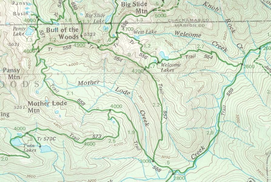 So that brings me to the question of your photo and where that trail sign is. Having never been where that photo was taken, I came up with 4 possibilities:
1) the junction w/ #555 on the ridge to the west,
2) further down that same ridge at the junction w/ #557 Geronimo,
3) at the junction where #556 and #554 meet near Welcome Lakes,
4) at the trail junction on Elk Lake Creek Trail #559.
Am I even close, or is there other possible places for that sign?
So that brings me to the question of your photo and where that trail sign is. Having never been where that photo was taken, I came up with 4 possibilities:
1) the junction w/ #555 on the ridge to the west,
2) further down that same ridge at the junction w/ #557 Geronimo,
3) at the junction where #556 and #554 meet near Welcome Lakes,
4) at the trail junction on Elk Lake Creek Trail #559.
Am I even close, or is there other possible places for that sign?
I thought that was odd, so I looked at my Green Trails Battle Ax map and it showed me the real picture. The west portion of the #554 had been taken off the map as well as the infamous Geronimo Trail that plunges down off the end of the ridge. All that I could find of the Geronimo Trail on our current district map was that they left the 557 number on the ridge, but without the trail.
So that brings me to the question of your photo and where that trail sign is. Having never been where that photo was taken, I came up with 4 possibilities:
1) the junction w/ #555 on the ridge to the west,
2) further down that same ridge at the junction w/ #557 Geronimo,
3) at the junction where #556 and #554 meet near Welcome Lakes,
4) at the trail junction on Elk Lake Creek Trail #559.
Am I even close, or is there other possible places for that sign?D
Don,
The Trail 554 photo was taken at the lower end of the Welcome Lakes trail where it meets Elk Lake Creek trail 559. It's not far from the point where trail 559 fords Elk Lake Creek.
It's interesting that the District map doesn't show the upper end of the 554 trail from Upper Welcome Lake to the Mother Lode trail. Although I haven't hiked that particular stretch of trail in a few years, the last time I was on it, it seemed like a perfectly good trail. Cartographer's error, maybe? I can see removing the Geronimo trail from the map as it is officially abandoned and unmaintained, but they may have inadvertently removed more trail from the map then just the Geronimo trail.
D
Here is a photo from one of our abandoned trails in the district, that I believe should be brought back into the current district trails. Enjoy the view.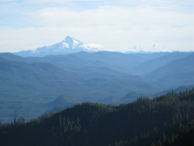
R
Well, since no one has had a new guess on my trail, I'll put out one more clue - this particular location was the site of an old lookout.
R
Donald Presley said:
Beautiful view!!! Any other hints. It doesn't ring any bells for me.....You've found so many abandonded trails, I can't keep track of them all.
Here is a photo from one of our abandoned trails in the district, that I believe should be brought back into the current district trails. Enjoy the view.
Beautiful view!!! Any other hints. It doesn't ring any bells for me.....You've found so many abandonded trails, I can't keep track of them all.
D
Rob Williams said:
Is that the trail that follows a bit of road near the top of Squaw Mountain?
Well, since no one has had a new guess on my trail, I'll put out one more clue - this particular location was the site of an old lookout.
Is that the trail that follows a bit of road near the top of Squaw Mountain?
D
Rob Williams said:
That little knob down in the bottom of the canyon that is directly below Mt Jefferson is Austin Point. If you were to draw a line from Mt Jefferson through Austin Point and on up further into our district that line will cross the ridge that this trail is on. I know that Mt Jefferson isn't on our district map, but is about 2 miles due south of Jefferson Park, which is on our map. So just line it up with the edge of the paper our map is printed on and it is close enough to work. That line will intersect the Clackamas River at Lazy Bend on Hwy 224 if you followed it all the way up.
Donald Presley said:Here is a photo from one of our abandoned trails in the district, that I believe should be brought back into the current district trails. Enjoy the view.
Beautiful view!!! Any other hints. It doesn't ring any bells for me.....You've found so many abandonded trails, I can't keep track of them all.
That little knob down in the bottom of the canyon that is directly below Mt Jefferson is Austin Point. If you were to draw a line from Mt Jefferson through Austin Point and on up further into our district that line will cross the ridge that this trail is on. I know that Mt Jefferson isn't on our district map, but is about 2 miles due south of Jefferson Park, which is on our map. So just line it up with the edge of the paper our map is printed on and it is close enough to work. That line will intersect the Clackamas River at Lazy Bend on Hwy 224 if you followed it all the way up.
R
Doug Firman said:
A little too far north, but you are thinking correctly. It is a very similar looking spot.
Is that the trail that follows a bit of road near the top of Squaw Mountain?
A little too far north, but you are thinking correctly. It is a very similar looking spot.
R
Donald Presley said:
Fish Creek Mountain?
Rob Williams said: That little knob down in the bottom of the canyon that is directly below Mt Jefferson is Austin Point. If you were to draw a line from Mt Jefferson through Austin Point and on up further into our district that line will cross the ridge that this trail is on. I know that Mt Jefferson isn't on our district map, but is about 2 miles due south of Jefferson Park, which is on our map. So just line it up with the edge of the paper our map is printed on and it is close enough to work. That line will intersect the Clackamas River at Lazy Bend on Hwy 224 if you followed it all the way up.
Fish Creek Mountain?
Log in to reply.