
What trail am I on?
D
Zach said:
Rob:Yes, that fish did come from Surprise Lake and it is easily the biggest trout I have ever caught in the Clack Dist. I kind of took it as my reward for the hard work put in to get there, it was a very surreal experience. I often imagine the damage I could do in a couple days spent up there.The picture was taken from an unofficial trail I believe, definitely not in a wilderness area. I learned about it from a discussion thread on here a while back. It may be hard to see, but the actual trail is on the far right of the picture.
So I take it, you ate that creature. My only question would be, did you take it with a fly? It looked to be 12-16 inches long, but looks can be decieving. I tend to flyfish more as I age, and I am not sure why? My most enjoyable moments seem to be around letting go those fish which were the hardest to catch.
Don
R
That is not the Fish Creek Mtn trail, but you aren't too far away. I'm pretty sure it is more lightly used than that trail. I don't really know why it doesn't get much traffic, as it has LOTS of view and very interesting scenery.
Fishing - I like to fly fish (but I'm not very good), however I usually can't at these high alpine lakes because most of them are so brushed in, my line always gets caught. So I end up either using a bubble trying to imitate a fly line, or just use a lure or powerbait....The trout usually love powerbait, but if I use it, I know I'm more than likely going to kill the fish because they usually swallow the hook!
D
I am thinking you are on 502 between Squaw Mountain and Twin Springs.
Donovan
R
You are too far north.
Z
Don:
I did not keep the rainbow from the picture. I have practiced catch and release fishing for a while now, though on ocassion I will keep and fry a brookie while backpacking. Seeing a stringer full of fish that will probably never make it out of the freezer, or a campfire full of foil, is what turns me off about fishing.
What I enjoy most about fishing is the 'take'. That and 'discovering' a lake that has not seen man nor lure for a spell and holds the fish to prove it.
I do not fly fish and have never learned how. I almost strictly use lures. I didn't measure that rainbow from surprise lake, but my fingers together measure four inches. I would guess that it was easily between 16 and 18 inches. It was a beast, and the only one that touched my lure after about a hundred casts that day.
Rob:
I don't recognize that trail from your picture, but if it is as you describe and I have not hiked it, I will be kicking myself all winter.
D
Zach:
Thank you for giving an older man a chance at catching that fish again. I know what you mean in seeing stringers full of fish, for that was the way I was brought up. You had to catch your limit before you could stop fishing.
I changed my ways about 30 years ago and went pretty much catch and release and started flyfishing. Their is no better feeling then hooking a fish on a fly you tied, whether it be a 8 inch brookie or a 20 inch monster rainbow.
Rob: Could that be the Baty Butte / Boundary Trail, the #545?
D
Seems like that would be a memorable spot. For looking up before passing, if you know what I mean. I just can't place it. And I can't remember the Back Door well enough to say although I do remember a switchback to drop below a rock feature that was in the way.
I think I will go with Don, towards the south end of Baty/Joyce Trail.
D.
R
You guys have really good eyes....That is the Baty Butte Trail, and I'm pretty sure it was on the south end of it, near Joyce Lake. I was trying to get a photo that wasn't quite as evident which trail it was from, but you guys are just too good!
So, either Donovan or Don it is your turn. I guess technically Don got the answer first.
D
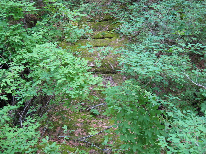
I guess it is my turn to post another photo. This one is from an abandoned trail section with an old plank bridge. It is not in a wilderness area.
D
Since I didn't get a response from my last posting, I thought I would give another clue.
If you have been to one of the trailheads of the last trail posted here, the Baty Butte Trail, you drove within a 100 feet of this bridge.
Don
R
I have to disqualify myself from this one....I know exactly which trail this is, as you showed it to me....It is a cool trail though.
D
Rob Williams said:
Rob: I have taken you on many abandoned trails, but I don't think this was one of them. Those are huckleberry bushes all over the trail and footbridge. Don
I have to disqualify myself from this one....I know exactly which trail this is, as you showed it to me....It is a cool trail though.
Rob: I have taken you on many abandoned trails, but I don't think this was one of them. Those are huckleberry bushes all over the trail and footbridge. Don
R
Donald Presley said:
Really? That looks vaguely familiar....In that case, I'm guessing this is the trail along the Clackamas that you have been looking for. Upstream from Switch Creek?
I have taken you on many abandoned trails, but I don't think this was one of them. Those are huckleberry bushes all over the trail and footbridge.
Really? That looks vaguely familiar....In that case, I'm guessing this is the trail along the Clackamas that you have been looking for. Upstream from Switch Creek?
D
This one is a little obscure Don.
But I believe at least three of us have been here, you, me, and .... come on out! Or maybe he didn't go down that far.
Donovan
D
Rob Williams said:
You will have to look up around 4000 feet, and further south and west in our district. Thats why I hinted at the huckleberries in the picture. Don
Donald Presley said:I have taken you on many abandoned trails, but I don't think this was one of them. Those are huckleberry bushes all over the trail and footbridge.
Really? That looks vaguely familiar....In that case, I'm guessing this is the trail along the Clackamas that you have been looking for. Upstream from Switch Creek?
You will have to look up around 4000 feet, and further south and west in our district. Thats why I hinted at the huckleberries in the picture. Don
D
Donovan said:
It is tad bit hard to figure out if you hadn't been there. It is one of those trails we may have to bring back online when all the decomissioning of roads is done just so we can access the trail this one ties into. Don
This one is a little obscure Don. But I believe at least three of us have been here, you, me, and .... come on out! Or maybe he didn't go down that far. Donovan
It is tad bit hard to figure out if you hadn't been there. It is one of those trails we may have to bring back online when all the decomissioning of roads is done just so we can access the trail this one ties into. Don
K
Okay, I'll make a guess. Is it Thunder Creek Trail?
D
Kirk, you just need to go a couple of creeks further west.
K
South Fork Mountain Trail?
D
Kirk Tolstrup said:
You are correct Kirk, so you will have to post the next photo. We currently only use about a mile of this trail to reach Baty Butte, but segments remain all the way down to Nohorn Creek that didn't get logged or roads built over it. Our district map doesn't even show the Baty Butte Trail. I insert a portion of our district map with some of my scratchings on it, but it hasn't been verified by a GPS yet. Be aware that these abandoned segments hadn't seen any maintenance for 50+ years, basically bushwacking. I have been on most of these segments only once or twice, they are pretty faint. Don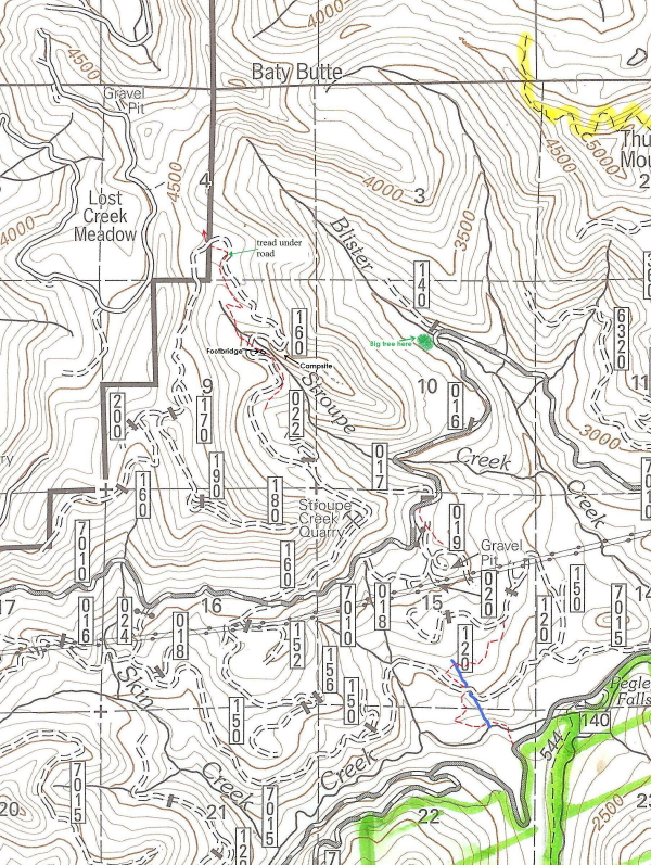
South Fork Mountain Trail?
You are correct Kirk, so you will have to post the next photo. We currently only use about a mile of this trail to reach Baty Butte, but segments remain all the way down to Nohorn Creek that didn't get logged or roads built over it. Our district map doesn't even show the Baty Butte Trail. I insert a portion of our district map with some of my scratchings on it, but it hasn't been verified by a GPS yet. Be aware that these abandoned segments hadn't seen any maintenance for 50+ years, basically bushwacking. I have been on most of these segments only once or twice, they are pretty faint. Don
Log in to reply.