
What trail am I on? Winter 2011
R
Don, you beat me by 3 minutes!!!! We must have been posting at the same time....
D
Don and Rob, you're both right. That was too easy, wasn't it? You guys can arm wrestle to see who gets to post the next one.
Doug
R
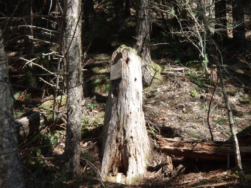
OK, this isn't a trail, but 100 bonus points for anyone who can identify where this tree/sign is located - I'll give one hint - it is to the side of a decomissioned road:
D
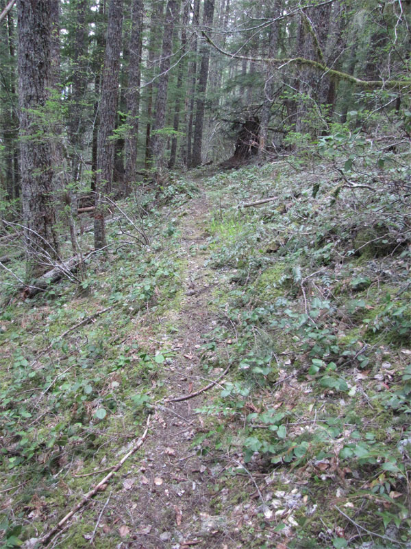
This photo is of a faint abandoned trail in our district. It was what I call a cut off trail, for starts on one trail and ends at another. Don't know if it ever had a name or number, but probably did back in the day.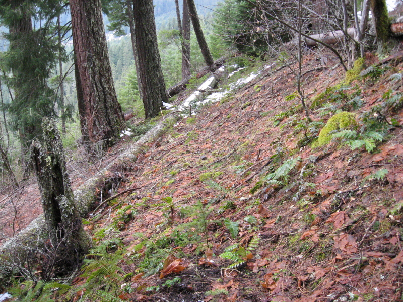 There are blazes on the trees and several switchbacks coming out of the canyon. I wasn't able to follow it all the way up last month because of deep snow above 3000 feet. The photo was taken down lower where the sun melted the snow near 2500 feet on a south slope. I might be able to reach the top now that it has warmed up a bit.
Don
There are blazes on the trees and several switchbacks coming out of the canyon. I wasn't able to follow it all the way up last month because of deep snow above 3000 feet. The photo was taken down lower where the sun melted the snow near 2500 feet on a south slope. I might be able to reach the top now that it has warmed up a bit.
DonP
Donald Presley said:
Don, In a previous post you mentioned a trail on the '38 map between Switch Creek and Lost Creek connecting the trail along the Clackamas R with the one running along the rim around Oak Grove Butte, so I'm guessing it is that one. BTW, I visited both the Lost Creek trail and Switch Creek trails yesterday for a couple of hundred yards each - I didn't see any obvious trail. Switch Creek looks the nicest, given the size of the trees in there I doubt that piece has ever been logged. --Paul
This photo is of a faint abandoned trail in our district. It was what I call a cut off trail, for starts on one trail and ends at another. Don't know if it ever had a name or number, but probably did back in the day.[...] There are blazes on the trees and several switchbacks coming out of the canyon. I wasn't able to follow it all the way up last month because of deep snow above 3000 feet. The photo was taken down lower where the sun melted the snow near 2500 feet on a south slope. I might be able to reach the top now that it has warmed up a bit. Don
Don, In a previous post you mentioned a trail on the '38 map between Switch Creek and Lost Creek connecting the trail along the Clackamas R with the one running along the rim around Oak Grove Butte, so I'm guessing it is that one. BTW, I visited both the Lost Creek trail and Switch Creek trails yesterday for a couple of hundred yards each - I didn't see any obvious trail. Switch Creek looks the nicest, given the size of the trees in there I doubt that piece has ever been logged. --Paul
D
Paul Turner said:
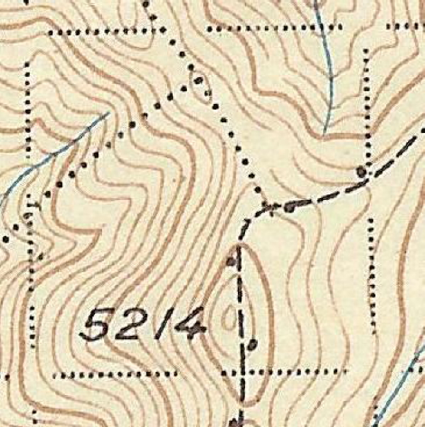
Paul you are correct, it is the cutoff trail between what I call the old Upper Clackamas River Trail in the bottom of the canyon and the Oak Grove Butte Trail up on the ridge. Here is a portion of the '38 with the trail on it.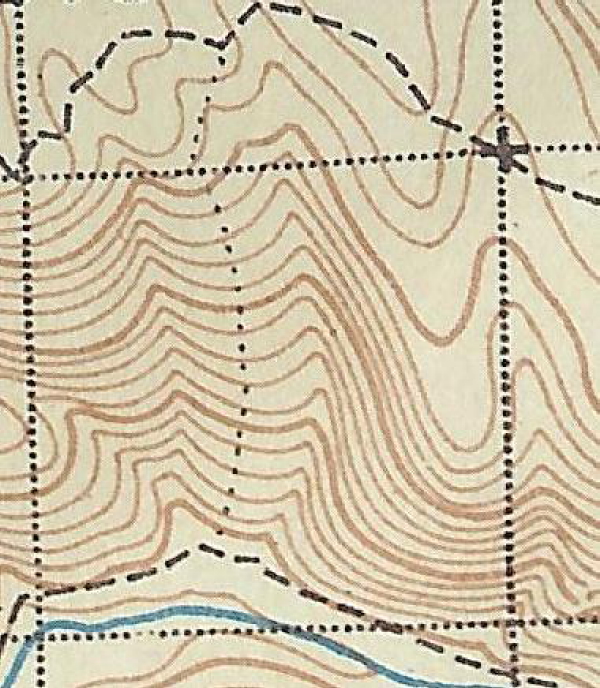 But as I had mentioned before, the trail actually follows a ridge one to the east of the one shown on the map.
As for the Lost Creek Trail I haven't had any luck locating that one yet, but I haven't spent much time at it either. The Switch Creek Trail is there and ties into the Oak Grove Butte Trail about a 1/4 mile below the 4640 road and brings you out at the 157 spur road. From there on up I haven't found anything yet, but about an 1/8 mile of tread coming from the old lookout site south. I did locate about a 1/2 mile of the old Oak Grove Butte Trail heading back towards Austin Meadow before it ends on an old logging road. The rest of that trail is pretty much gone except for a few 100 feet because of all the logging and road building. I think it would make a good starting point for someone, like yourself who wanted to bushwack through the old growth west onto the rocky bluffs down river and coming out at the junction of the 46 and 63 roads.
When the snow finally melts up on high, I will get back up there and look around Oak Grove Butte and east.
But as I had mentioned before, the trail actually follows a ridge one to the east of the one shown on the map.
As for the Lost Creek Trail I haven't had any luck locating that one yet, but I haven't spent much time at it either. The Switch Creek Trail is there and ties into the Oak Grove Butte Trail about a 1/4 mile below the 4640 road and brings you out at the 157 spur road. From there on up I haven't found anything yet, but about an 1/8 mile of tread coming from the old lookout site south. I did locate about a 1/2 mile of the old Oak Grove Butte Trail heading back towards Austin Meadow before it ends on an old logging road. The rest of that trail is pretty much gone except for a few 100 feet because of all the logging and road building. I think it would make a good starting point for someone, like yourself who wanted to bushwack through the old growth west onto the rocky bluffs down river and coming out at the junction of the 46 and 63 roads.
When the snow finally melts up on high, I will get back up there and look around Oak Grove Butte and east.
Don, In a previous post you mentioned a trail on the '38 map between Switch Creek and Lost Creek connecting the trail along the Clackamas R with the one running along the rim around Oak Grove Butte, so I'm guessing it is that one. BTW, I visited both the Lost Creek trail and Switch Creek trails yesterday for a couple of hundred yards each – I didn't see any obvious trail. Switch Creek looks the nicest, given the size of the trees in there I doubt that piece has ever been logged. –Paul
Paul you are correct, it is the cutoff trail between what I call the old Upper Clackamas River Trail in the bottom of the canyon and the Oak Grove Butte Trail up on the ridge. Here is a portion of the '38 with the trail on it.
But as I had mentioned before, the trail actually follows a ridge one to the east of the one shown on the map.
As for the Lost Creek Trail I haven't had any luck locating that one yet, but I haven't spent much time at it either. The Switch Creek Trail is there and ties into the Oak Grove Butte Trail about a 1/4 mile below the 4640 road and brings you out at the 157 spur road. From there on up I haven't found anything yet, but about an 1/8 mile of tread coming from the old lookout site south. I did locate about a 1/2 mile of the old Oak Grove Butte Trail heading back towards Austin Meadow before it ends on an old logging road. The rest of that trail is pretty much gone except for a few 100 feet because of all the logging and road building. I think it would make a good starting point for someone, like yourself who wanted to bushwack through the old growth west onto the rocky bluffs down river and coming out at the junction of the 46 and 63 roads.
When the snow finally melts up on high, I will get back up there and look around Oak Grove Butte and east.P
Don,
I'm not clear on which ridge the connector is. Have I located it properly on the following map? Also, on the '38 map there is a trail that runs across the south face and looks to be aligned along the marked road fragment, is there anything there?
I've got no picture to carry on, I'll try to round up a map fragment.
Thx,
--Paul

P
OK, try this one,
Here is a map fragment consisting of 2 trails intersecting, the one I'm interested in is the dotted trail on the eastern end and going south, what peak is this trail's destination? I hope to put these 2 trails together for a loop sometime this season. 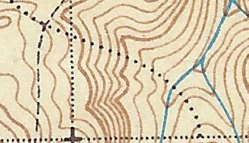 --Paul
--PaulD
Paul Turner said:
Paul this is what I think I have found on the ground, but it hasn't been verified with a GPS unit. The blue line is a decommissioned road and the red line is the trail that I have been up so far once last month. Like I said it goes up one ridge to east of where it looks on the map. I turned around in deep snow before I ran into any roads, but I am sure I will when I get back up there.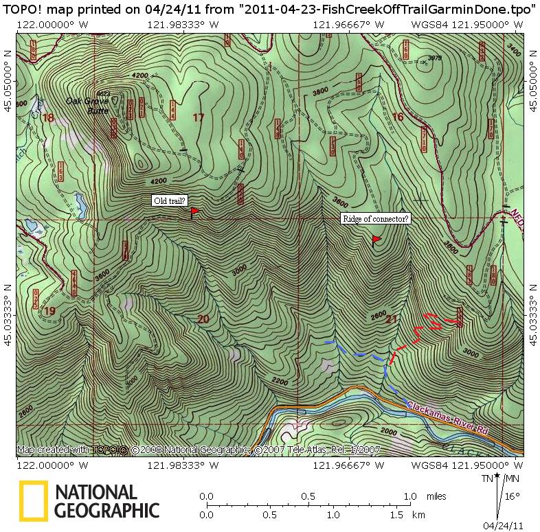 As far as the trail heading east at the end of the road, I haven't been there yet. I have been up the ridge that comes from the SW of Oak Grove Butte, but not from the SE or on the segment that goes where your road is depicted. When the snow melts, I plan on checking it out.
Don
As far as the trail heading east at the end of the road, I haven't been there yet. I have been up the ridge that comes from the SW of Oak Grove Butte, but not from the SE or on the segment that goes where your road is depicted. When the snow melts, I plan on checking it out.
Don
Don, I'm not clear on which ridge the connector is. Have I located it properly on the following map? Also, on the '38 map there is a trail that runs across the south face and looks to be aligned along the marked road fragment, is there anything there? I've got no picture to carry on, I'll try to round up a map fragment. Thx, --Paul
Paul this is what I think I have found on the ground, but it hasn't been verified with a GPS unit. The blue line is a decommissioned road and the red line is the trail that I have been up so far once last month. Like I said it goes up one ridge to east of where it looks on the map. I turned around in deep snow before I ran into any roads, but I am sure I will when I get back up there.
As far as the trail heading east at the end of the road, I haven't been there yet. I have been up the ridge that comes from the SW of Oak Grove Butte, but not from the SE or on the segment that goes where your road is depicted. When the snow melts, I plan on checking it out.
DonD
Paul Turner said:
That looks the trail up to Wanderers Peak after crossing Memaloose Creek. Don
OK, try this one, Here is a map fragment consisting of 2 trails intersecting, the one I'm interested in is the dotted trail on the eastern end and going south, what peak is this trail's destination? I hope to put these 2 trails together for a loop sometime this season.
That looks the trail up to Wanderers Peak after crossing Memaloose Creek. Don
P
Donald Presley said:
You would be correct. Have you explored this particular trail? --Paul
Paul Turner said:OK, try this one, Here is a map fragment consisting of 2 trails intersecting, the one I'm interested in is the dotted trail on the eastern end and going south, what peak is this trail's destination? I hope to put these 2 trails together for a loop sometime this season. –Paul
That looks the trail up to Wanderers Peak after crossing Memaloose Creek. Don
You would be correct. Have you explored this particular trail? --Paul
D
Here is another map section of the '38 map with trails on it. Can you tell me the names of any of the three trails depicted on the map.
 Paul I haven't been on that trail that goes up to Wanderers Peak after crossing Memaloose Creek, but it looks interesting. Have you been in that area before?
Don
Paul I haven't been on that trail that goes up to Wanderers Peak after crossing Memaloose Creek, but it looks interesting. Have you been in that area before?
Don
Paul I haven't been on that trail that goes up to Wanderers Peak after crossing Memaloose Creek, but it looks interesting. Have you been in that area before?
DonP
Donald Presley said:
No I have not been there, the plan would be to do a loop around Memaloose Lake and then down to the trail in question and back through Wanderers Peak, etc. --Paul
[...] Paul I haven't been on that trail that goes up to Wanderers Peak after crossing Memaloose Creek, but it looks interesting. Have you been in that area before? Don
No I have not been there, the plan would be to do a loop around Memaloose Lake and then down to the trail in question and back through Wanderers Peak, etc. --Paul
D
P
Donald Presley said:
Don, Rho Ridge Trail. Think there might a viable route along that Buckeye Creek segment? Going on my list. --Paul
[...] No takers on the trails on the '38 map segment. Here's a hint: The mainline trail with the phoneline following it, the phoneline stops at the lookout to the NE, but the trail continues on. To the south, the trail and phoneline continue to a couple of lookouts and an old guard station. Don
Don, Rho Ridge Trail. Think there might a viable route along that Buckeye Creek segment? Going on my list. --Paul
D
Paul Turner said:
Paul you are correct, it was the Rho Ridge Trail between Mt Lowe and Burnt Granite Lookouts. As far as the Buckeye Creek Trail, I have been down in there a ways from the top where there is a game trail heading down into the canyon. I need to get back up there some day and do a thorough search, because sometimes these dotted trails on the map didn't even exist. Your to post another photo or map segment. Don
Don, Rho Ridge Trail. Think there might a viable route along that Buckeye Creek segment? Going on my list. --Paul
Paul you are correct, it was the Rho Ridge Trail between Mt Lowe and Burnt Granite Lookouts. As far as the Buckeye Creek Trail, I have been down in there a ways from the top where there is a game trail heading down into the canyon. I need to get back up there some day and do a thorough search, because sometimes these dotted trails on the map didn't even exist. Your to post another photo or map segment. Don
P
Here is a photo of a piece of trail, I believe it is now in new wilderness, a quiet interlude between two much abused segments of the same trail.
D
Paul would that be out towards Cache Meadows on an old abandoned segment of trail?
P
Donald Presley said:
Don, Go northwest and eventually you'll get there. --Paul
Paul would that be out towards Cache Meadows on an old abandoned segment of trail?
Don, Go northwest and eventually you'll get there. --Paul
D
I think that's the last nice link of Huxley Lake Trail.
Donovan
Log in to reply.