
What trail am I on?
K
How about Lower Lake?
D
Would this be Wall Lake along the Red Lake Trail #719?
D
Has that view burned since you took the picture?
Donovan
R
I'm going to guess Top lake. I think the trail is right in front of the shot, at the edge of the lake. I swear I've hiked around/over that old, dead tree....
M
No to none of those. The lake hasn't burned recently; I took the picture last October. I've never done the Lower Lake Loop or Red Lake, so all those hikes are out. They've been on my to-do list for awhile but the Olallie Lake area is far enough away that I only get there maybe once a year.
K
Now I'm thinking that view looks like the south end of Monon Lake.
R
How about Sheep Lake? If that isn't it, is it on a current trail? Or were you on another one of your off trail/abandoned trail adventures when you took this photo?
M
Rob Williams said
 The lake is inside the reservation.
How about Sheep Lake? If that isn't it, is it on a current trail? Or were you on another one of your off trail/abandoned trail adventures when you took this photo?Not Sheep Lake. Here's a clue: it is a current trail as far as I can tell, but I'm not sure it receives much maintenance past the reservation boundary.
D
How about the Gibson Lake Trail #708?
Don
M
Donald Presley said
How about the Gibson Lake Trail #708? DonThat's it. Last fall my wife and I did a loop with the Horseshoe Saddle Trail, Ruddy Hill, the Gibson Lake Trail and the PCT. It was cloudy so we couldn't see Jefferson for much of the day but it was still a really nice loop. Gibson Lake is beautiful. Your turn.
D
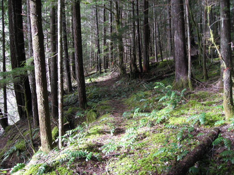 This photo is of an abandoned trail in our district that was replaced by a road sometime in the 50's or early 60's. There is about a 1 1/2 - 2 mile segment left that has several small creek crossings and is a realitively flat hike, except for climbing over some down logs.
Don
This photo is of an abandoned trail in our district that was replaced by a road sometime in the 50's or early 60's. There is about a 1 1/2 - 2 mile segment left that has several small creek crossings and is a realitively flat hike, except for climbing over some down logs.
DonR
I think I was standing right next to you so that pretty much makes me disqualified. We'd be a crooked quiz-show. No big payoffs though...
D
Robert Koscik said
I think I was standing right next to you so that pretty much makes me disqualified. We'd be a crooked quiz-show. No big payoffs though...Not if yer still drinking Oly, anon.
D
 I know I should have said "except Robert" when I put up that photo, for you were the only one that I know of who has been on that trail except me. I have talked about this trail in the past on this website, so that is another clue. Here is another clue:
Don
I know I should have said "except Robert" when I put up that photo, for you were the only one that I know of who has been on that trail except me. I have talked about this trail in the past on this website, so that is another clue. Here is another clue:
DonB
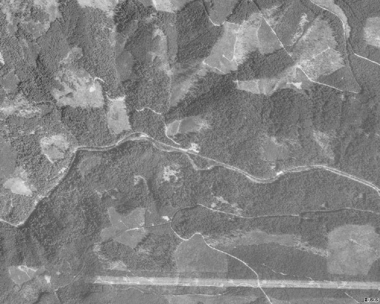
The 1935 Forest Service maps show trails south of the Clackamas and north of Big Granite which are probably it.
D
 Bryon, I think what you are seeing on the map is the lower leg of the Burnt Granite Trail that a couple of us have been trying to locate, which I call the "Lower BG". It used to join up with the trail in question on the northside of the Clackamas less than a mile west of the Pot Creek Cabin site.
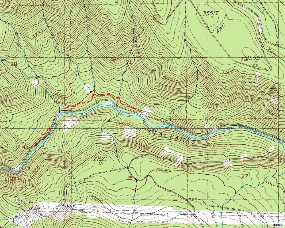
For a lack of another name, I call the trail in question, the Upper Clackamas River Trail or UCRT. It followed the Clackamas from just west of Austin Hot Springs to Pot Creek Cabin and on up the river. The 46 road wiped out most of the trail, but I have been able to locate about a 1-1/2 mile segment and other pieces. The following map shows the segments in red:
Bryon you can go ahead and post a new photo and start the ball rolling again.
Bryon, I think what you are seeing on the map is the lower leg of the Burnt Granite Trail that a couple of us have been trying to locate, which I call the "Lower BG". It used to join up with the trail in question on the northside of the Clackamas less than a mile west of the Pot Creek Cabin site.
For a lack of another name, I call the trail in question, the Upper Clackamas River Trail or UCRT. It followed the Clackamas from just west of Austin Hot Springs to Pot Creek Cabin and on up the river. The 46 road wiped out most of the trail, but I have been able to locate about a 1-1/2 mile segment and other pieces. The following map shows the segments in red:
Bryon you can go ahead and post a new photo and start the ball rolling again.B
This photo was taken a few steps off the trail to the more or less West or WNW.
The trail was once famous, then abandoned, and now back but seeing limited use.
It is not in a wilderness.
And thanks for the map - I have found some sections along the river but not that one.
 I like the new drag and drop picture upload feature. Very quick upload speed compared to before. And I see that it now will accept 2 mb picture files.
I like the new drag and drop picture upload feature. Very quick upload speed compared to before. And I see that it now will accept 2 mb picture files.R
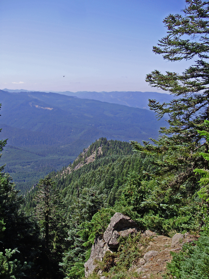
I'm going to take a wild guess and say it is from the Rimrock overlook trail on Mt Mitchell?
B
The trail in question is quite a few miles from Mount Mitchell.
The particular viewpoint is as high or even higher that the Mount Mitchell overlook. It is not taken from the highpoint of the trail.
D
Would this be the Rho Ridge Trail by chance?
Don
Log in to reply.