
What trail am I on? - Part 2
Joe Keller said:
Ok, after the BotW hiint, I fugred it was Pansy Lake, although I've never seen it. I guess the original comment about the new wilderness areas threw us off.
I really need to get a good map of the new wilderness areas..... I just looked at the Pansy Lake trail map and realized almost the whole trail is in BoTW. I thought it didn't pass into it until farther down the trail. My bad.....
Rob Williams said:Well, I have no idea where this tree might be, and all this secret decoder ring and aliens talk isn't helping!
The clue is in the message.
Back, back in time, it's getting late and you are spose' to be somewhere with the mules. . . thunderheads are building.
Donovan said:The clue is in the message.
Back, back in time, it's getting late and you are spose' to be somewhere with the mules. . . thunderheads are building.
And the last place you want to be during a thunderstorm is where the pictograph is leading you to. So don't go there and you won't have to deal with an alien abduction or a thunderstorm threating. The blaze itself is along the trail not high on the ridge, but the trail follows a ridge for the most part along it's length in a west to east or is it a east to west direction.
Joe Keller said:Ok, after the BotW hiint, I fugred it was Pansy Lake, although I've never seen it. I guess the original comment about the new wilderness areas threw us off.
That was what threw me off. Eventhough it 'wasn't in one of the new wilderness areas', it was in the only wilderness area we use to have in our district, but that wasn't mentioned or nobody asked that question. I quess we all need to ask more questions when we don't know what trail somebody is talking about.
OK, I'll take a stab…..Whetstone Mtn trail? That is an East/West trail that goes along a ridge for a lot of it….
I'm guessing it means 2 miles to something (a peak?) It looks like a triangle (peak?) on top, followed by 2M and then I'm not sure what is on the third line....
Rob Williams said:OK, I'll take a stab…..Whetstone Mtn trail? That is an East/West trail that goes along a ridge for a lot of it….
I'm guessing it means 2 miles to something (a peak?) It looks like a triangle (peak?) on top, followed by 2M and then I'm not sure what is on the third line....
You the man! The blaze is two miles east of Whetstone Mtn along the trail as you head towards Silver King Mtn near the junction with trail#3369. It is easy to miss, for the blaze faces the trail rather than being perpendicular to it as most blazes are. I couldn't figure out the third line either. But one person in particular thinks it gives reference to an alien landing site, it could be possible.
Your turn to post a new picture.
Donald Presley said:
You the man! The blaze is two miles east of Whetstone Mtn along the trail as you head towards Silver King Mtn near the junction with trail#3369. It is easy to miss, for the blaze faces the trail rather than being perpendicular to it as most blazes are. I couldn't figure out the third line either. But one person in particular thinks it gives reference to an alien landing site, it could be possible.
Your turn to post a new picture.
Well, there aren't too many trails that run east/west along a ridge that I'm aware of......My second guess would have been Rimrock....
So what is the first line? Is is a mountain? And the 2M is 2 miles? It has been a while since I've been on that section of trail, but I don't recall seeing it.
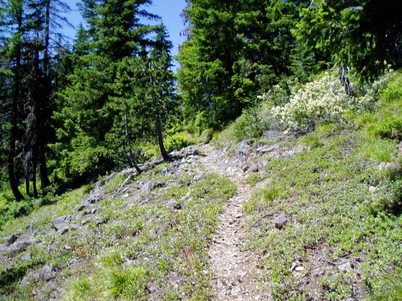
OK, new picture. This is on a trail in a wilderness area. It is a very lightly used trail.
Rob Williams said:
Well, there aren't too many trails that run east/west along a ridge that I'm aware of......My second guess would have been Rimrock....
So what is the first line? Is is a mountain? And the 2M is 2 miles? It has been a while since I've been on that section of trail, but I don't recall seeing it.
This is my interpretation of the blaze /pictograph: The triangle means a peak or mountain; 2M, means 2 miles, and the other figure isn't clear, so it is left to ones own opinion or fantasy.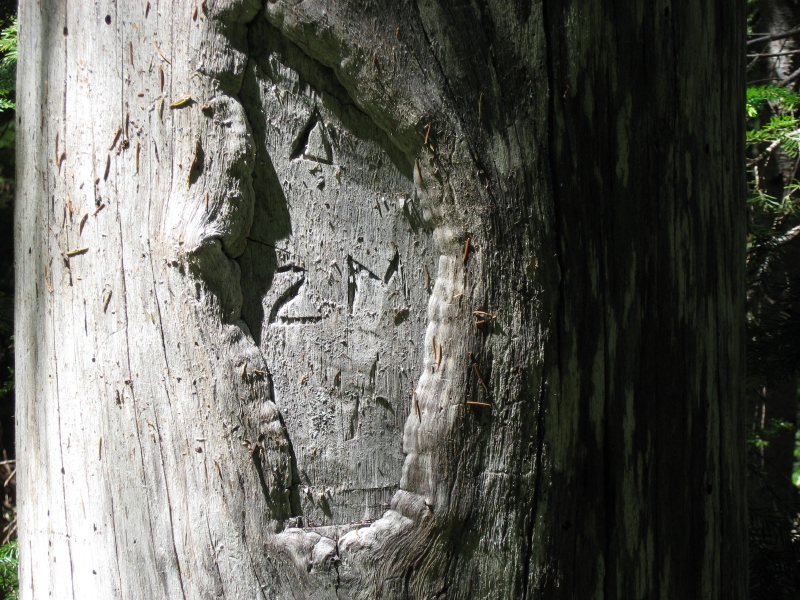
Rob Williams said:OK, new picture. This is on a trail in a wilderness area. It is a very lightly used trail.

Is this trail in an old wilderness area or one of the new areas?
Donald Presley said:
Is this trail in an old wilderness area or one of the new areas?
It is in an old wilderness area.
Rob Williams said:It is in an old wilderness area.
Ok. So if this is in the Bull of the Woods Wilderness, I still need more info, for this picture isn't doing it for me. So is picture taken on a through trail or a destination trail?
Donald Presley said:
Ok. So if this is in the Bull of the Woods Wilderness, I still need more info, for this picture isn't doing it for me. So is picture taken on a through trail or a destination trail?
It is a destination, not a connector trail. I think that is what you are asking. There is a "prize" at the end of the trail.
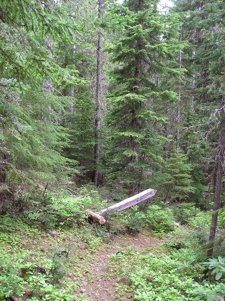
Doug Firman said:Is it the trail that leads to the top of Big Slide Mountain, overlooking Lake Lenore?
What trail would that be?
Doug Firman said:That would be the Schreiner Peak Trail #555.
Ding, ding ding!!!! We have a winner! That shot was from the top of the trail, just before you head down to Lake Lenore. The trail used to on past that section on to Schreiner Peak, but that piece has been lost I guess.
Your turn to post a photo...
Doug Firman said:I'm going to have do defer posting a picture until later in the week. I am leaving within the hour for a few days out of town and don't have time at the moment. So if anyone else wants to jump in right now, feel free.
Doug takes real interesting pictures. I am looking forward to seeing what he comes up with. So even if someone jumps in, let's hold him to it later.
Well, I see that nobody jumped in while I was gone. So I guess that it's my turn now.
This trail is a through trail and is not in a wilderness area.
Log in to reply.