
What trail am I on?
R
kirk said Okay, after Rob's ministration, it should work this time. Yay! It worked this time.Is the color in the hill in the background burned trees or are they red (like in the fall)?
K
Is the color in the hill in the background burned trees or are they red (like in the fall)?A clue to the locale of this trail, is in that hill... At this juncture, I'll just leave it at that.
B
kirk said Where was that last picture taken? It reminds me of the area around Mt. Lowe.Its a ways south of Lowe where the trail first starts to drop more steeply. Maybe a mile or so. Bryon
R
Well, based on your "clue" it leads me to believe that might be Ruddy hill, but it doesn't look exactly like Ruddy hill (at least not how I remember it). But, I'll take a stab in the dark and say it is from the PCT.
K
Rob Williams said
Well, based on your "clue" it leads me to believe that might be Ruddy hill, but it doesn't look exactly like Ruddy hill (at least not how I remember it). But, I'll take a stab in the dark and say it is from the PCT.
You win! If I remember correctly I took this picture at the junction of the PCT and Skyline Trail. The reason it might not look like you remember is because I'm not a very good photographer and I don't have a very good camera. Here's another picture from the same spot. It's a little more ruddy than the first one.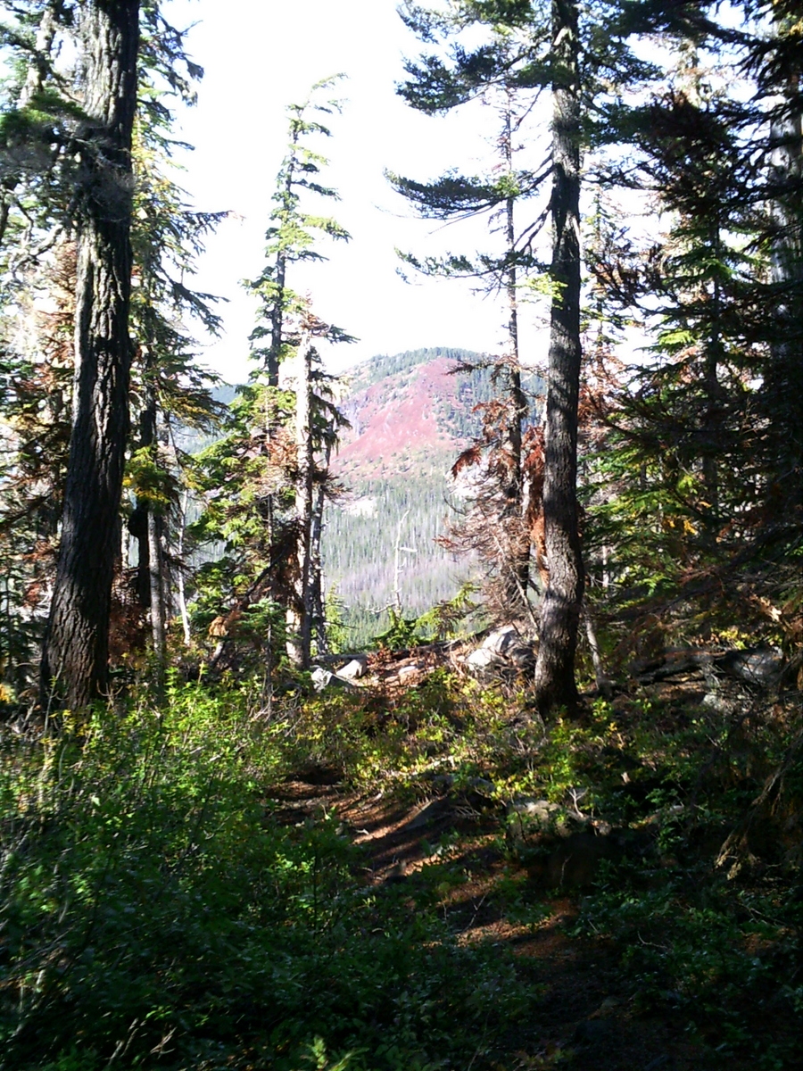
R
Well, based on how my last photo went, I'd rather not post another photo. Anyone else want to post one?
M
I'll bite here.
 This is a trail in a Wilderness Area. If it isn't in the district it's darn close.
This is a trail in a Wilderness Area. If it isn't in the district it's darn close.K
It looks like a trail that gets a lot of feet on it. Is that an accurate assessment?
M
kirk said It looks like a trail that gets a lot of feet on it. Is that an accurate assessment?Accurate enough. We only saw 2 groups but it's more popular than some trails in that area.
K
So, it's in a wilderness area and there are "some trails" in the area. Just to narrow the field a bit, would the wilderness area in question be Bull of the Woods?
M
kirk said So, it's in a wilderness area and there are "some trails" in the area. Just to narrow the field a bit, would the wilderness area in question be Bull of the Woods?That would be correct.
D
I'll narrow the field with a suspicion, never having been there, the slopes of Battle Ax?
D
M
Donovan said I'll narrow the field with a suspicion, never having been there, the slopes of Battle Ax? DYou are correct. Your turn!
D
Someone will have to stand in for me.
I have a new to me computer that has Vista on it. It downloaded my pictures but it put them somewhere without asking and I can't find them.
D.
B
Nobodys biting, so here goes:
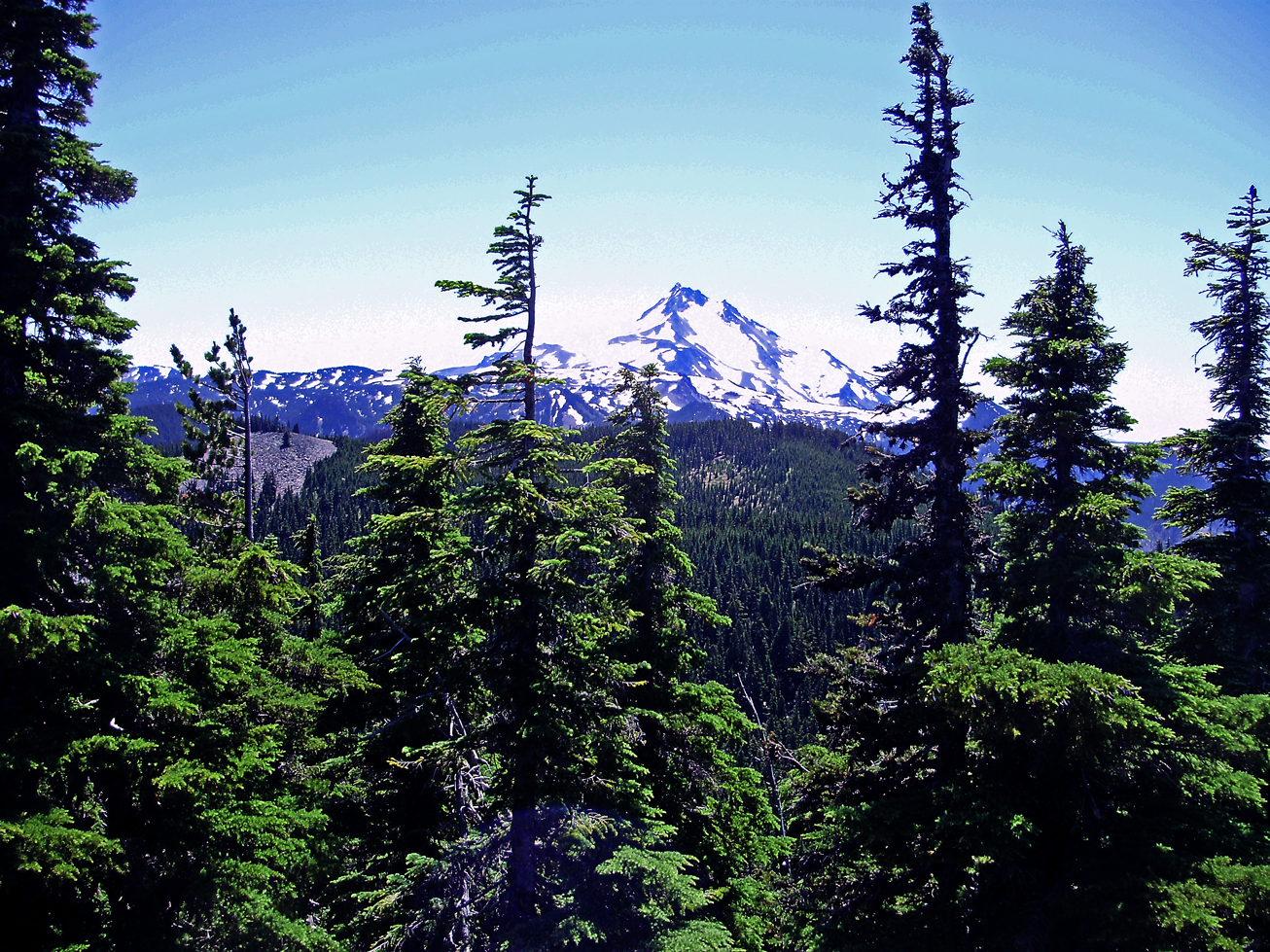
At the end of what trail was this picture taken?
K
Just so I can get my bearings, is that next hill toward the mountain, Battle Ax?
M
Bryon Boyce said Nobodys biting, so here goes: At the end of what trail was this picture taken?I haven't been up there but that looks like the view from Double Peaks. It's got to be somewhere in the Olallie Lake area.
K
Whoa... I was way too far west.
B
So the last two winners haven't even been to the site shown and still they get it right! Are you guys good or what?  Matt, you got this one. That's Jeff from Double Peaks. Your turn to go.
The Double Peaks Trail is shown inaccurately on many maps. It does not go up the east face, which would require serious climbing iron. Instead the route passes to the north of the peak and finally makes its way steeply up the NW side.
Matt, you got this one. That's Jeff from Double Peaks. Your turn to go.
The Double Peaks Trail is shown inaccurately on many maps. It does not go up the east face, which would require serious climbing iron. Instead the route passes to the north of the peak and finally makes its way steeply up the NW side.
M
Bryon Boyce said So the last two winners haven't even been to the site shown and still they get it right! Are you guys good or what?I only got it because it looked so much like the view from Ruddy Hill. They have different access points but are so close to one another I figured that had to be Double Peaks. I don't know if this is permitted or not but I've run out of photos you guys won't easily get. This is a photo taken about 20 feet from a "trailhead" to an unofficial trail in the district. If you guess the body of water, you guess the trailhead and therefore the trail.

Log in to reply.