
What trail am I on?
R
Bryon Boyce said The Double Peaks Trail is shown inaccurately on many maps. It does not go up the east face, which would require serious climbing iron. Instead the route passes to the north of the peak and finally makes its way steeply up the NW side.Just a plug for the maps here - the double peaks trail map shows the actual route to the top. Many of the current maps don't show a trail, but the USGS map that does show it is reasonably accurate - but the overlay we have is the actual GPS track of the trail to the top. That trail gets STEEP in places, but is mostly well graded.
M
Okay, nobody took a guess. It's a viewpoint of Fish Creek from just off the road at the "trailhead".
I'll offer another one:
 This one should be much easier.
This one should be much easier.R
Was that photo of Fish Creek taken at the "trailhead" or up the road a ways? I've hiked that section several times, and I think I might have a photo of the same place (from a slightly different angle), but it is hard to tell.
Your new photo kind of looks like Round Lake.
M
Right where you park for Fish Creek is a short user trail (20 feet maybe) that leads to that viewpoint. I'm planning to go back in early fall to take better photos of the spot.
As for the current photo, it's not Round Lake. Go west / northwest maybe 10 miles.
I've never been to Round Lake. Is it nice? What's the drive like? Can I do it in a Nissan Sentra?
R
Matt Reeder said Right where you park for Fish Creek is a short user trail (20 feet maybe) that leads to that viewpoint. I'm planning to go back in early fall to take better photos of the spot. As for the current photo, it's not Round Lake. Go west / northwest maybe 10 miles. I've never been to Round Lake. Is it nice? What's the drive like? Can I do it in a Nissan Sentra?Hmm, I've never seen that user trail, but then I was never looking for a trail over there. Round Lake is nice - I've never camped there, but there are several nice campsites. The trip over isn't terribly rough, but it is a LONG trip. The road used to go through from 63 (I think), but it washed out at some point in the past, so you have to go the long way around. The lake is almost to the washed out section.
D
Would that be Skookum Lake by chance?
Don
M
Donald Presley said Would that be Skookum Lake by chance? DonToo far to the west. It's between Skookum and Round and is accessible by a relatively popular trail.
B
Would that be Pansy Lake?
Bryon
M
Bryon Boyce said Would that be Pansy Lake? BryonIndeed. It's your turn!
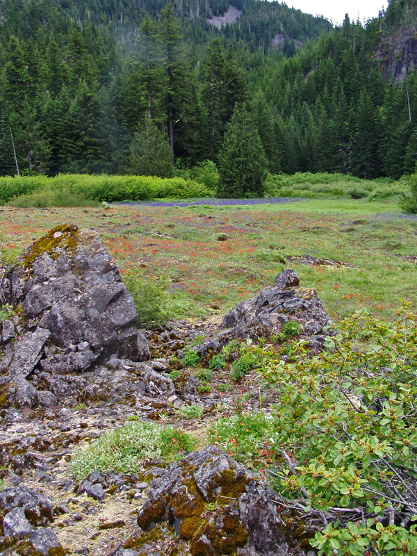
B
The abandoned trail in question is in the middle distance at the far edge of the flowering meadow. It heads across the meadows near the free-standing Alaska Cedar.
Bryon
R
That looks like a very interesting place. I can't say as though it rings any bells to me. I'm going to need a hint (or two or three).
B
It is in a wilderness area. There is a nearby official trail that gets quite a bit of use.
Bryon
D
This trail is still a mystery to me so far. Is this in the BOTW Wilderness? I get out a lot in our district with the exception of the BOTW, maybe once a year.
Don
B
Donald Presley said This trail is still a mystery to me so far. Is this in the BOTW Wilderness? DonYes it is. Not far left from the picture is a little used campground. Bryon
K
I've heard that the Pansy Lake Trail was rerouted, and I recently saw a trail junction where it looked like you could head down closer to the creek. Is it that trail?
B
kirk said I've heard that the Pansy Lake Trail was rerouted, and I recently saw a trail junction where it looked like you could head down closer to the creek. Is it that trail?That trail was originally made to keep access to the campground I mentioned in my last post. The abandoned trail passes through that abandoned campground, so you win! There is no creek in this valley as once out of Pansy Lake it dives underground into landslide deposits, and except during extreme water events does not reappear until past the access road. The same goes for the creek you pass just before your junction. This abandoned trail starts near the road (I've never been able to find the last little section up to the road) and after crossing Pansy Basin / Meadows climbs sometimes steeply up the west side of the valley to Bob Bagby's mine above Pansy Lake and up the glacier-shaped valley headwall. This basin has many unusual features most hikers miss entirely - they are to be seen only from the abandoned trail or off trail. Bryon
K
Okay, here's the next picture for our game:
D
Pretty picture.
D
K
Donovan said Pretty picture. DAlmost, but not quite scenic
D
This looks to be in the area of the current fire closure south of Olallie?
Don
Log in to reply.