
What trail am I on?
That was a pretty big hint. I wonder if the red fire box parts are still up there. It has been a while since I have been up there. I like sitting on the "Potatoes" on the south side. I remember seriously doubting it was a real trail at first it is so steep. It had been neglected for quite some time.
I also remeber a pretty nice camp and lake at the east side of it before the trail starts the ramp up.
The seasons to enjoy it are far too short.
Here comes the next contest picture.
Donovan
I don't recall seeing a red fire box up there. The first time I was there (with my daughter) we missed the side trail to the "potatoes". The last time I was up there a few months ago I made that my destination and didn't actually go all the way to the top. I was running way behind schedule that day, and almost turned around, but quickened my pace so I could spend a few minutes on the potatoes. It is a breathtaking view, but you do pay for it on the trail on the way up. Very steep and very poor footing. At least that part isn't very long.
Just need some sort of hint on your photo now.....I have to say, it looks familiar to me.
Donovan said:That was a pretty big hint. I wonder if the red fire box parts are still up there. It has been a while since I have been up there. I like sitting on the "Potatoes" on the south side. I remember seriously doubting it was a real trail at first it is so steep. It had been neglected for quite some time.
I also remeber a pretty nice camp and lake at the east side of it before the trail starts the ramp up.
The seasons to enjoy it are far too short.
Here comes the next contest picture.
Donovan
This trail is a short connector. High elevation, and not in any wilderness.
Yes Rob, east side.
Getting close Don. Clue: head up the hill.
PS The high point is a landmark from all around, not named, but look like two highpoints that are.
Donovan
Donovan said:Yes Rob, east side.
Getting close Don. Clue: head up the hill.
PS The high point is a landmark from all around, not named, but look like two highpoints that are.
Donovan
I am guessing here. Is it Upper Lake off of the PCT?
Don needs to head south on the PCT and Rob needs to turn around (assuming you are standing at the shore of Gibson Lake) and head back to the PCT and head towards Don (oh, and your're not 'spose to be on the Res anyway).
Mystery trail is not I – 5, whooops, I mean I -PCT.
Donovan
Donovan said:Don needs to head south on the PCT and Rob needs to turn around (assuming you are standing at the shore of Gibson Lake) and head back to the PCT and head towards Don (oh, and your're not 'spose to be on the Res anyway).
Mystery trail is not I – 5, whooops, I mean I -PCT.
Donovan
Ruddy Hill Trail #714?
Wait a minute. Don, did you pass Rob? You need to turn around and head North now. And look for Rob. Unless he ran down from Horseshoe Saddle to look at the lake, with my picture in hand, to compare. In which case he'e on his way back up to the PCT.
Ruddy Hill is a hill, Don. We are looking for a lake. Remeber, it's a connector trail.
Donovan
Well, I thought I knew what trail it was, but with all this running around the Olallie area, I got a little winded and confused.
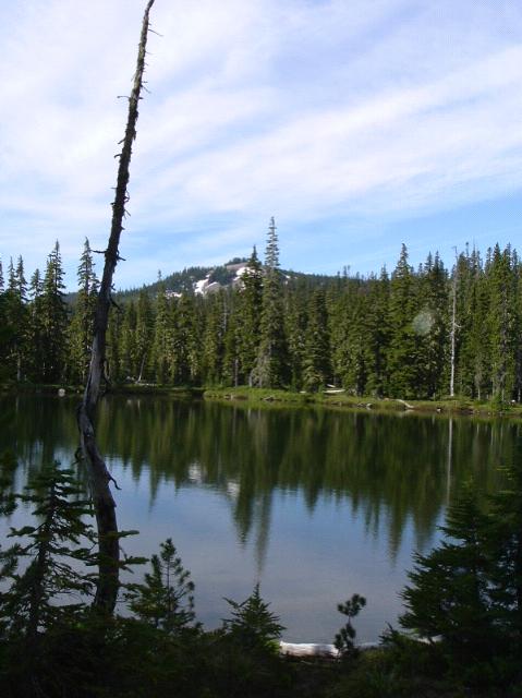
It wouldn't be Top Lake looking south would it?
Timber Lake trail was a pretty good guess, but Rob get's the prize. It is Top Lake on Top Lake Trail. It's a nice place. Nice area on the south end of the lake. Trail leads up to Cigar Lake on the I-PCT.
That rocky high point is pretty dominant around there. The PCT loops by it.
Now you all do remember that the Skyline Trail first ran along Olallie-Monon-Horseshoe Lakes to Gibson and Breitenbush and didn't wander around the higher ground.
Donovan
Donovan said:Timber Lake trail was a pretty good guess, but Rob get's the prize. It is Top Lake on Top Lake Trail. It's a nice place. Nice area on the south end of the lake. Trail leads up to Cigar Lake on the I-PCT.
That rocky high point is pretty dominant around there. The PCT loops by it.
Now you all do remember that the Skyline Trail first ran along Olallie-Monon-Horseshoe Lakes to Gibson and Breitenbush and didn't wander around the higher ground.
Donovan
Is that rocky high point south of the lake? I was there late last year and it is a nice place.
Interesting stuff.....
Upper Lake was my original thought, but I knew it was wrong because of the trail. But that hill was sure familiar looking.
I am having fun following this game, even if I'm not ready for the big leagues.
Joe Keller said:Upper Lake was my original thought, but I knew it was wrong because of the trail. But that hill was sure familiar looking.
I am having fun following this game, even if I'm not ready for the big leagues.
Joe:
It is all in good fun. Just jump in and make some guesses or ask a question. I've had a lot of fun with it. If you have a picture of a trail you'd like to post, you can take my place. I've got to do some searching to find a good one (hoepfully).
Since nobody posted a new trail, I thought that I would throw another one out there.
This is a current district trail, and is a destination or connector trail, depending on how you use it.
Donald Presley said:Since nobody posted a new trail, I thought that I would throw another one out there.
This is a current district trail, and is a destination or connector trail, depending on how you use it.
I was trying to come up with a good picture, but was having trouble.
Is this in a wilderness area? If so, is it new or old wilderness? I have an idea, but want to hear the answers first.
Log in to reply.