
What trail am I on? - Part 2
Rob Williams said:It wouldn't be the Pansy Lake trail would it? Maybe the junction with the Dickey Lake trail? Just making a guess....
No, but you're in the right wilderness.
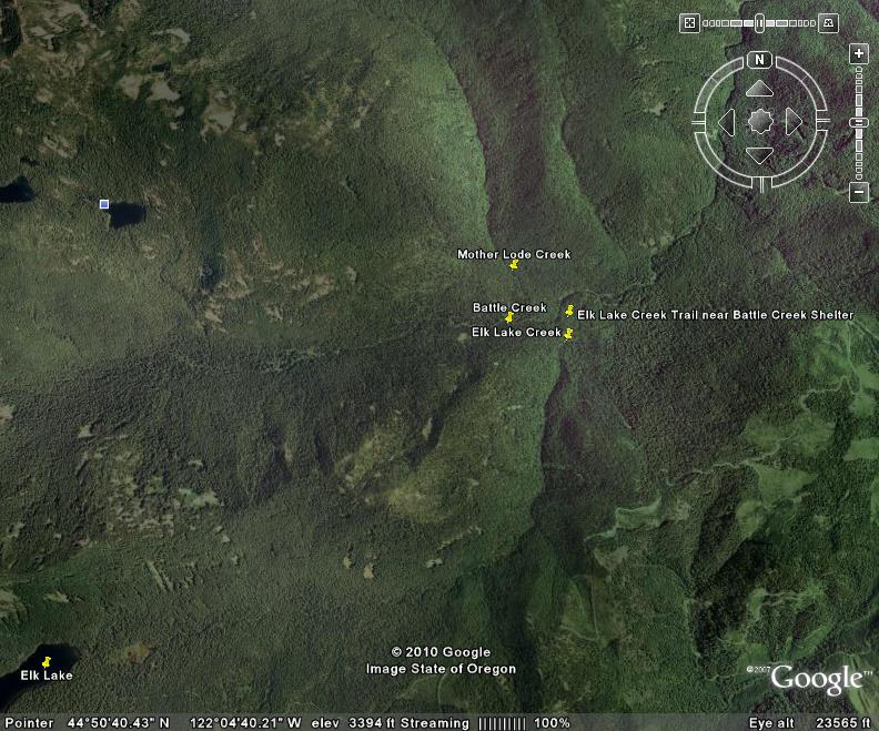
It is the Elk Lake Creek trail, and the photo was taken just downstream of the Battle Creek shelter area, the area of campsites that I mentioned. The two creeks are Battle Creek and Elk Lake Creek. The trail junction is with the Mother Lode Trail in the Battle Creek shelter area.
Here is a photo from Google Earth which might help.
Doug Firman said:It is the Elk Lake Creek trail, and the photo was taken just downstream of the Battle Creek shelter area, the area of campsites that I mentioned. The two creeks are Battle Creek and Elk Lake Creek. The trail junction is with the Mother Lode Trail in the Battle Creek shelter area.
Here is a photo from Google Earth which might help.

I have never been to this spot on the trail. Which trail do you usually use to reach the area in question? I have hiked up Elk Lake Creek Trail a ways, but not that far. From our district map, it looks like it is closer to hike down from Elk Lake. Or for the more adventurist type, to bushwack in from the south from the logging roads just out of the wilderness area.
Don,
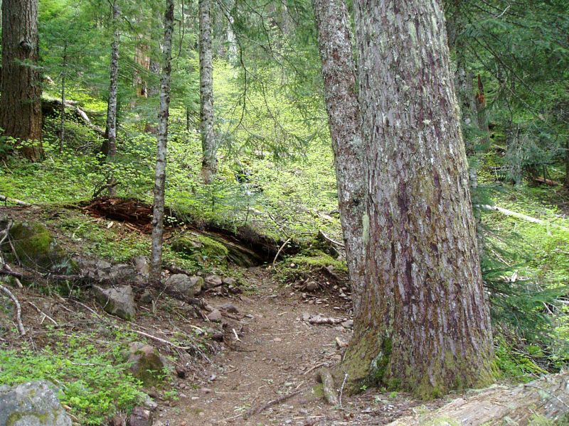
I hike the Elk Lake Creek trail starting at the Collawash trailhead. It's about 5 miles from there to Battle Creek shelter and the spot where I took that photo. Be prepared to get your feet wet, as you will need to ford Elk Lake Creek twice and Battle Creek once to get there. And of course again if you return by the same route.
Here are some photos of that stretch of trail.
Doug Firman said:It is the Elk Lake Creek trail, and the photo was taken just downstream of the Battle Creek shelter area, the area of campsites that I mentioned. The two creeks are Battle Creek and Elk Lake Creek. The trail junction is with the Mother Lode Trail in the Battle Creek shelter area.
I was there with my daughter last summer and don't remember seeing that log. That Battle Creek shelter area is HUGE though, so it is possible we missed it. A very pretty area. The only part of that trail I haven't been on is the north end, from the north trailhead to the junction with the Welcome Lakes trail.
Hey Doug:
I'm pretty sure this the same crossing, but at different times of the year. The one from your flicker page on the north side, shows it being pretty high:

The one from my page shows it being much lower, although this is looking at it from the south side:

Rob, you're right, it's the same crossing looking at it from different sides of the stream. After the spring runoff, it's usually not much more than knee-deep. But you're still going to get your feet wet!
Doug Firman said:Rob, you're right, it's the same crossing looking at it from different sides of the stream. After the spring runoff, it's usually not much more than knee-deep. But you're still going to get your feet wet!
Oh yes. That is one thing that was unique about that trail. All the creek crossings - and most of them required you to get wet, even in the summer. It was pretty cool, though. I didn't find any of the crossings too difficult, but many were knee deep. I remember when we were going up the trail, we were pretty hot, and the cold water on the feet felt REALLY good....
Rob Williams said:Doug Firman said:Rob, you're right, it's the same crossing looking at it from different sides of the stream. After the spring runoff, it's usually not much more than knee-deep. But you're still going to get your feet wet!
Oh yes. That is one thing that was unique about that trail. All the creek crossings - and most of them required you to get wet, even in the summer. It was pretty cool, though. I didn't find any of the crossings too difficult, but many were knee deep. I remember when we were going up the trail, we were pretty hot, and the cold water on the feet felt REALLY good....
That's my memory, too. A friend and I started a Memorial Day backpacking trip on that trail with three boys. The creek crossings were fairly high and wide, and we felt fortunate to find a good tree bridge for the third crossing. The boys sure enjoyed the swimming hole along the trail though.
That looks like "Poisin Oak Corner" on Dry Ridge Trail.
Are you talking about Professor Trail's corner talk while standing in a clump of poison oak on the Dry Ridge Trail.
That looks like "Poisin Oak Corner" on Dry Ridge Trail.
You are a little too far North and East.
Yes Don. That's what I was thinking. But now I think it's on Memaloose Lake Trail in the new Postage Stamp Wilderness.
You win! Your turn to post a photo. I'm running out of options....

Log in to reply.