
What trail am I on? Winter 2011
D
Could it be the Cripple Creek trail?
D
Kelly:
Now you have gone too far upriver. You drove past this trail's trailhead to go to the Riverside.
Doug:
It's not Cripple Creek.
D
I give up! It is the Alder Flat Trail. I didn't know that it would be that hard.
So if anyone wants to post a photo from one of our trails and start this game going again be my guest.
I hope other people got out last weekend with the clear weather we had and did some hiking or something. I was out last Sunday and hiked up one of our abandoned trails in the snow to get away from the city. There are several trails that are 'off the map' but still open to hiking in the winter, if you pick one that is on a south facing slope, or you can be with everyone else down on the Clackamas River. The "Sounds of Two Rivers Trail" near the Roaring River is always good. Cripple Creek Trail is also a good choice, wether you choose the lower or upper trailhead to start.
I went on a fairly new find up near Austin Hot Springs that is very similar to the "Sounds of Two Rivers Trail" in that it follows a south facing ridge with many switchbacks. There was only an inch or so of snow at the bottom, but ended up at about 6 inches of snow at 3000 feet at the top. The sun came out a few times, but that only helped the snow to fall out of the trees in clumps. It was a good day of hiking for February on the Clackamas.
I hope to get out next weekend, but with the snow down low, I have a feeling I won't be going up to high either.
Don
D
Donald Presley said:
Don, I thought it had to be Alder Flat from the clues you gave, but I didn't say anything because I didn't have any more pictures to post if I was right. So I went out today and took this one: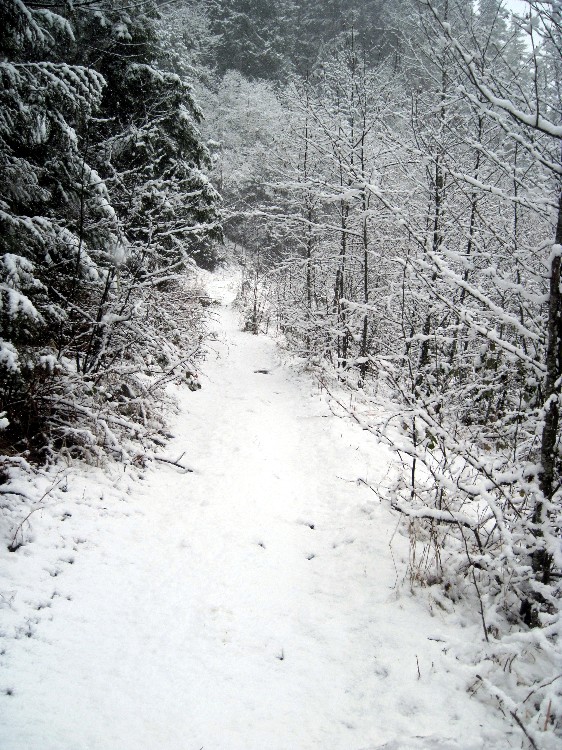 This is not an official trail, but it is a route that has been discussed on this forum. Maybe that's a little outside of the rules of this game, but this is where I went today to find some of that snow that everyone's been talking about, so this is the photo I have to offer. It's not in a wilderness area.
I give up! It is the Alder Flat Trail. I didn't know that it would be that hard. So if anyone wants to post a photo from one of our trails and start this game going again be my guest.
Don, I thought it had to be Alder Flat from the clues you gave, but I didn't say anything because I didn't have any more pictures to post if I was right. So I went out today and took this one:
This is not an official trail, but it is a route that has been discussed on this forum. Maybe that's a little outside of the rules of this game, but this is where I went today to find some of that snow that everyone's been talking about, so this is the photo I have to offer. It's not in a wilderness area.R
I knew it was Alder Flat too after your last clue. At first I thought it was that lower section of Cripple Creek we went on, so I didn't answer. After your clue I immediately knew where it was, especially since I just did that trail not too long ago.
I think the new photo is the old roadbed along Fish Creek. Those alders look pretty familiar.
I think we need to come up with a new game as people seem to be running out of photos. Maybe some variation of the map game that Don posted a while back?
D
Rob Williams said:
You're right, Rob. It's between the second and third creeks. It was a great place to go for a walk on a snowy morning.
I think the new photo is the old roadbed along Fish Creek. Those alders look pretty familiar.
You're right, Rob. It's between the second and third creeks. It was a great place to go for a walk on a snowy morning.
K
 I don't think this is on an official trail, although there is a faint trail leading the way...It is in the wilderness, and in the district. It's a very unique area...
K
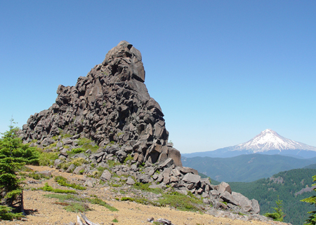
If that's the dike I think it is, then I agree that it's very interesting. The exposed portions of the dike make me think of an undulating rock serpent traveling across the surface of the earth.
K
Yes, even more so since this is one of two triangular shaped stacks between the buttes...
K
I think there may be a smaller third one to the north of the two larger ones. The next time I'm up there, I'm going to see if I can get a picture of them lined up.
K
Oh yeah, there is a number of bumps on this spine, but only two are triangular shaped. Very curious remnants...
K
Well from the view, I'd guess it's High Rock. Never been there, but I've seen that basic view before.
D
Thats the rock formations between the Signal Buttes in the Roaring River Wilderness. They are pretty cool and I would like to campout there sometime during the summer months as long as there wasn't any threats of lightning at the time.
I hiked out there the last time this last fall during a rainstorm with Rob and Kirk, but I didn't take any photos. I believe Rob has some photos of our adventure. It was my second time out there. The first time was back in the 80's when I bushwacked out there. This last time we came out on the Cougar Creek Trail and cutoff when the trail went down into the canyon and we headed towards the southern most butte. The funny thing was that I started both hikes from the same point, a wide spot in the 240 spur road out to Frazier Turnaround.
I didn't learn that, that spot was the trailhead of the Cougar Creek Trail until a few years ago when Donavon pointed it out to me. I have been working on locating that trail ever since, and I am about 80% done. Maybe this year I will be able to connect the segments. Anyone want to go on an adventure, I think that there are only 1-2 miles of trail left to locate. I only spent one day down there last year and that was the day before we hiked out to the Signal Buttes.
It takes a little bit of bushwacking to get out there, but it is well worth the time.
Don
K
Yes, you are correct. That is one of the formations between the Signal Buttes...
How about this adventure...I've always wanted to start at the south butte, and drop into the head waters of the Roaring River...and hike, scramble, bushwhack, rappel...whatever it took, to get to the highway, where I'd park a second car. I'd actually plan for a night out.
R
Donald Presley said:
Here is the link to the photos (I only took 7 – it wasn't a great day, weather wise) I think this one is the picture of the outcropping you posted, although the two triangular ones looked very similar. Very cool place, and had it been a clearer day, you would have QUITE a view from up there.
I hiked out there the last time this last fall during a rainstorm with Rob and Kirk, but I didn't take any photos. I believe Rob has some photos of our adventure.
Here is the link to the photos (I only took 7 – it wasn't a great day, weather wise) I think this one is the picture of the outcropping you posted, although the two triangular ones looked very similar. Very cool place, and had it been a clearer day, you would have QUITE a view from up there.
K
Okay Don, you made the correct ID for the last picture. It's your turn to post a picture.
D
I was going to post something last night, but got busy with family.
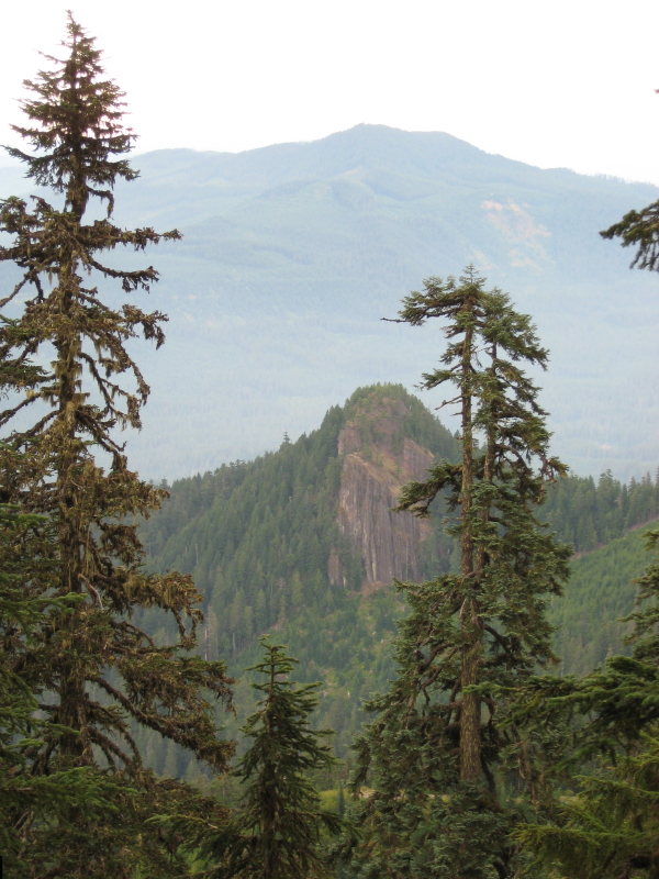
In keeping with geological features seen out there on the trail or off, I submit the following photo taken from a trail in our district.
D
There were no replys to the photo I posted over the weekend, so I thought that I should give another hint.
The prominent point on the ridge in the background was once a site of a lookout.
The rocky knob in the foreground I believe was a volcanic vent. The cliffs are 100-200 feet tall and seem to be made of fused cinders and rock. I had taken my children to the top on several occasions in the past 20 years for it is an easy scramble on it's eastern face, that is not shown in this view.
Don
D
Still no replys. The high point in the background is Oak Grove Butte, and by the way, this trail is one of the abandoned ones in our district. So you will have to get out an older map, or search the ones on our website, to locate this trail.
D
Here is another hint. Sandstone Creek is between where this photo was taken and the prominent rock formation in the foreground. You can line up Oak Grove Butte and this knob, which I believe they call 'Mistletoe', and you will get a line that intersects this old trail. You will need to look at the '38 or '46 maps to see the trail.
Don
Log in to reply.