
What trail am I on? Winter 2011
R
Well, I don't have really anything to post if I get it right, but I really enjoy looking at those old maps. I thought that point might have been mistletoe - I remember you talking about it.
I'm thinking the trail you are thinking of is one of two trails:
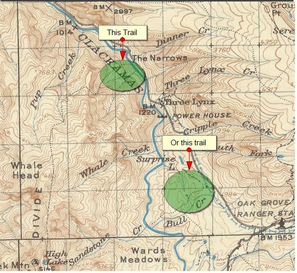
- The old Pup Creek Trail that comes down kind of from Whalehead
- The trail that goes along Bull Creek - looks like it hits the old railroad grade and it even looks like there is still a piece of trail going up to Surprise Lake (at least on the current MyTopo maps):
D
Rob you are right, when you said it was the trail coming down Pup Creek from Whale Head. It didn't come down Cat Creek as the '38 map shows as you know, for we have hiked down that segment. The trail went from the Clackamas River at Pup Creek all the way south to Thunder Mtn and onto Baty Butte. The Fish Creek Mtn Trail is a segment of that trail. The photo was taken from an abandoned segment between Whale Head and Fish Creek Mtn.
This portion of the the '38 map shows where I took the photo by aligning Oak Grove Butte with the small knob known as 'Mistletoe' near Sandstone Creek :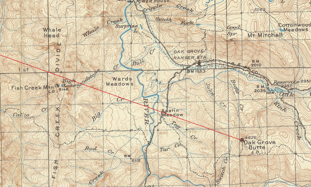 Hopefully whenever the snowmelts this spring or early summer above 4000 feet, I can take you up there. It was snowing up there again today around 2500 feet and higher. I was up the Clackamas doing my annual Chainsaw/Crosscut saw certification class with the Forest Service. We were across the road from the Lazy Bend Campground doing the cutting portion of the class where we only got sprinkled on, but when I drove home I could see from pass above North Fork Reservoir that it was snowing up higher.
Might have to run up there tomorrow and play in the new snow.
Don
Hopefully whenever the snowmelts this spring or early summer above 4000 feet, I can take you up there. It was snowing up there again today around 2500 feet and higher. I was up the Clackamas doing my annual Chainsaw/Crosscut saw certification class with the Forest Service. We were across the road from the Lazy Bend Campground doing the cutting portion of the class where we only got sprinkled on, but when I drove home I could see from pass above North Fork Reservoir that it was snowing up higher.
Might have to run up there tomorrow and play in the new snow.
DonD
Well, if nobody else wants to start the ball rolling again, I guess I will.
This photo was taken a few feet from an abandoned trail that I am sure starts in our district, but is out of district in this photo. The photo was taken during a spring hike, or more of a bushwhack to a lake to see what it was like.
R
Any hints as to where it might be? It doesn't ring any bells for me....
D
You will need to look along the western edge of the district to find the lake. I believe it was an old BLM trail. I neglected to take a picture of the trail sign and I have yet to find the trail on a map.
D
I should have added that I didn't know that a trail existed in the area when I chose to bushwhack out to the lake in the spring a couple of years ago, I just wanted to get out and hike.
I searched through the early maps and the lake or the trail don't show up. The lake starts showing up in the 60-70's maps, but I don't see any reference to any trail that comes down the creek below the lake. That was where I first saw the trail when I followed the creek back down towards my rig parked on a lower road.
D
Here's another clue. You need to look up near the headwaters of the South Fork.
R
OK, I'm going to make a complete guess here - I'm going to guess Williams lake. I'm basing that on two things - one, that it is near the headwaters of the South Fork, and two, I seem to recall you talking about Williams lake once before. The other candidate would be Helen Lake, but I think that it too far south.
D
Rob you are correct, it is Williams Lake. Like I said, I have yet to see the trail on a map, but I don't have any old BLM maps that could possibly show the trail. The sign I saw, I believe had a date from the 60's, so it should be on a map.
Your turn.
R
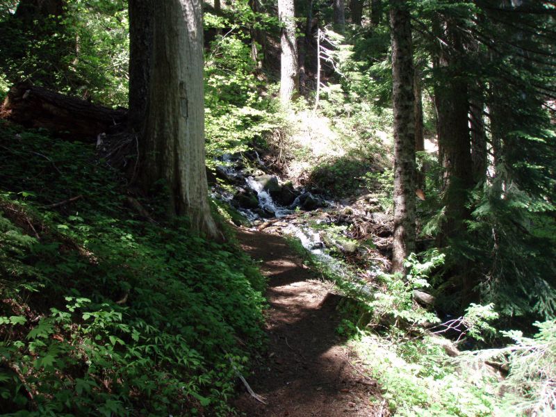
OK, I've dug up another photo......This may be a re-run (the trail), but I'm pretty sure this photo is new. This was taken on a current district trail that resides in a wilderness area. It is a reasonably busy trail.
R
Don:
Where did you get to the lake? Off which road?
D
Rob Williams said:
I parked on the 4540 road just up a ways from the 45 road because the snow was too deep to go any further. I walked south on the 4540 road until I came into uncut timber due east of the lake. I climbed up the ridge crossing the 4530 road and continued heading west until I was above the lake. I climbed down to the lake and went around the westside of the lake and found a road comes to the lake at the NW corner.There was an abandoned tent at that site. I continued around the lake and found an old trail following the creek from the lake. I remember seeing a sign or placque on the trail, but for some reason I didn't take a picture.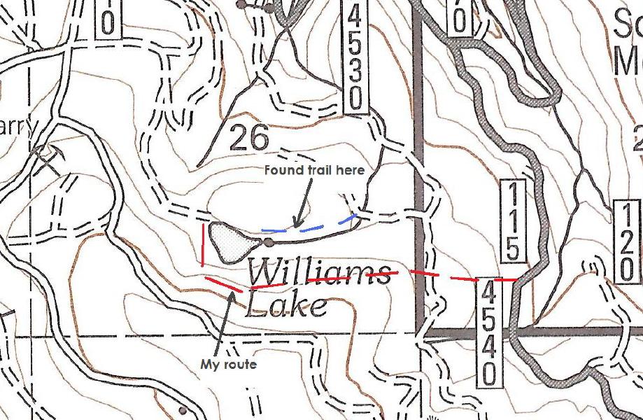
Don: Where did you get to the lake? Off which road?
I parked on the 4540 road just up a ways from the 45 road because the snow was too deep to go any further. I walked south on the 4540 road until I came into uncut timber due east of the lake. I climbed up the ridge crossing the 4530 road and continued heading west until I was above the lake. I climbed down to the lake and went around the westside of the lake and found a road comes to the lake at the NW corner.There was an abandoned tent at that site. I continued around the lake and found an old trail following the creek from the lake. I remember seeing a sign or placque on the trail, but for some reason I didn't take a picture.
D
Rob Williams said:
OK, I've dug up another photo......This may be a re-run (the trail), but I'm pretty sure this photo is new. This was taken on a current district trail that resides in a wilderness area. It is a reasonably busy trail.
R
This trail is in an old wilderness area.
R
OK, no one has had any interest, so I'll post another clue. This trail is relatively short and ends up at a lake.
So, to summarize:
- In an old wilderness area
- Is reasonably well used
- Is relatively short
- Ends up at a lake
K
Pansy?
R
No, but based on my clues you should be correct. I shouldn't try and do these clues when I 'm really rushed for time. I got Pansy mixed up with the mystery trail. The myster trail IS in a wilderness area, however it is a NEW wilderness area, not an old one.
Sorry!
K
I'll take a stab at it. Is it Memaloose Lake?
R
You are correct! Your turn to post a photo or map segment.....
K
Michelle (my wife) and I spent a very cold night at Memaloose Lake many years ago. So long ago that it was the B.C. era (before children). If I remember correctly we tried to fit in one sleeping bag to get warm, but I don't think we were entirely successful. I remember it being a long night.
Okay Rob, I don't think I have any pictures that would be challenging at all. You mentioned map segments, do you mean a very small section of a map with a trail on it? Can you show me an example?
Log in to reply.