
What trail am I on? Winter 2011
R
Here is a link to a posting that Don did quite a while ago. We've had a couple of map postings, but it would be good to get something like this going. You can look at the old maps we have on the maps page, or scan in a portion of an old map you have. It needs to be a relatively small section, but have something that someone could key off of to find the trail. It is an interesting puzzle I think.
D
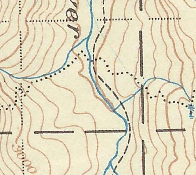
So everybody seems to be out of photos, just like me. Here is a map segment with a trail on it. You tell me which trail am I on. It is a portion of the '38 Mt Hood Nat'l Forest map. I like this map, with all of it's faults, because I happen to own a copy. It has a scale of 1/2 " per mile, but it's beauty isn't seen until you blow it up.
I have been to the benchmark on this trail.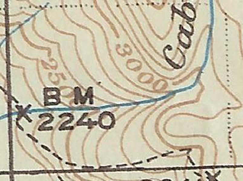
D
The map segment I posted hasn't drawn any response, so I thought I should give another clue.
The section of trail with the benchmark is about a 1/2 mile from the upper Clackamas River.
Don
R
I'm not sure of the name of the trail, but it is in the Big Bottom area. The creek shown is Cabin Creek.
I see reference to a "Pot Creek Cabin" just north of there - do you know if any remnants of that cabin are still there?
D
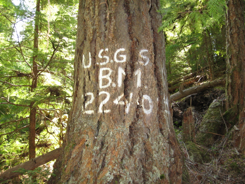
Rob you are correct. I don't know what the name of the trail was either. I do know that the benchmark is still there and that the trail was made into a road at least in that area and later abandoned. If I show a larger view of the map segment the trail location is obvious with Big Bottom nearby.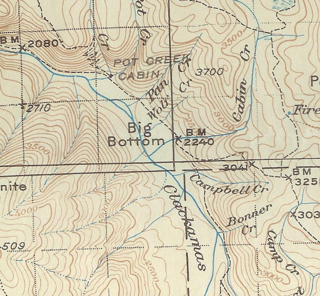 Here is a picture of the benchmark, it is the only one I have seen like this.
 As far as the Pot Creek Cabin, I have been to the site, but there isn't anything left. It is an offroad campsite in a grove of old trees at the present time. And that trail switchbacking up the ridge just to the north of the cabin I haven't been able to locate it yet, and it ties into the Oak Grove Butte Trail. Where I thought the trail was is now a clear cut. Having only spent a few hours looking for the trail so far I haven't given up on it yet, for sometimes the trail is in the wrong place on the map, or the map omits ridges or creeks.
I hope to get up there this spring when the snow melts to look for that trail as well as others in the upper Clackamas River area.
So it is your turn to post another map segment or photo of a trail in our district.
Don
As far as the Pot Creek Cabin, I have been to the site, but there isn't anything left. It is an offroad campsite in a grove of old trees at the present time. And that trail switchbacking up the ridge just to the north of the cabin I haven't been able to locate it yet, and it ties into the Oak Grove Butte Trail. Where I thought the trail was is now a clear cut. Having only spent a few hours looking for the trail so far I haven't given up on it yet, for sometimes the trail is in the wrong place on the map, or the map omits ridges or creeks.
I hope to get up there this spring when the snow melts to look for that trail as well as others in the upper Clackamas River area.
So it is your turn to post another map segment or photo of a trail in our district.
Don
Here is a picture of the benchmark, it is the only one I have seen like this.
As far as the Pot Creek Cabin, I have been to the site, but there isn't anything left. It is an offroad campsite in a grove of old trees at the present time. And that trail switchbacking up the ridge just to the north of the cabin I haven't been able to locate it yet, and it ties into the Oak Grove Butte Trail. Where I thought the trail was is now a clear cut. Having only spent a few hours looking for the trail so far I haven't given up on it yet, for sometimes the trail is in the wrong place on the map, or the map omits ridges or creeks.
I hope to get up there this spring when the snow melts to look for that trail as well as others in the upper Clackamas River area.
So it is your turn to post another map segment or photo of a trail in our district.
DonP
Donald Presley said:
Don, I've got a hike planned starting from the trail that used to go up Switch Creek, which I believe you have mentioned a time or two, then on up to the former lookout site (are there any views there?) then make my way east by whatever means to follow the route you mention here that follows Lost Creek (the 1956 map calls this the Pot Creek Trail). I'd do it as a loop either bike and hike or follow the road and get on what I believe is a trail you mentioned in a previous post that is is above the road. Have you explored the Switch Creek portion to the old lookout? Assuming there is a segment above and following the road, how much of it is there between Switch Creek and Lost Creek? I figure about 3000' elevation gain to the lookout site, it would be great to have a trail through this area. --Paul
[...] Here is a picture of the benchmark, it is the only one I have seen like this.That's an interesting marking, is it the tree bark spreading that distorts the letters? Looks like it.
[...] And that trail switchbacking up the ridge just to the north of the cabin I haven't been able to locate it yet, and it ties into the Oak Grove Butte Trail. Where I thought the trail was is now a clear cut. Having only spent a few hours looking for the trail so far I haven't given up on it yet, for sometimes the trail is in the wrong place on the map, or the map omits ridges or creeks. I hope to get up there this spring when the snow melts to look for that trail as well as others in the upper Clackamas River area. So it is your turn to post another map segment or photo of a trail in our district. Don
Don, I've got a hike planned starting from the trail that used to go up Switch Creek, which I believe you have mentioned a time or two, then on up to the former lookout site (are there any views there?) then make my way east by whatever means to follow the route you mention here that follows Lost Creek (the 1956 map calls this the Pot Creek Trail). I'd do it as a loop either bike and hike or follow the road and get on what I believe is a trail you mentioned in a previous post that is is above the road. Have you explored the Switch Creek portion to the old lookout? Assuming there is a segment above and following the road, how much of it is there between Switch Creek and Lost Creek? I figure about 3000' elevation gain to the lookout site, it would be great to have a trail through this area. --Paul
D
Paul
How have you been? Don't hear from you much these days.
There is an old trail going up Switch Creek that is fairly easy to follow once you get up to the crossing and on up to the 4640 road. From there onto Oak Grove Butte, I haven't had much luck in locating the tread for I believe most of it is under roads. I did find a faint trail coming south / southeast from the old lookout site for about a 1/4 mile, but haven't tied it into anything yet. There are some nice veiws from the old lookout site.
As far as going from Oak Grove Butte to the Pot Creek or the Lost Creek Trail, you are pretty much on your own, for I haven't even looked in that area yet, otherthan trying to come up from the Pot Creek Cabin and looking in a clearcut where I thought the trail should go.
I have found a segment of the old trail that came along the river a mile or so above Austin Hot Springs that they didn't get wiped out with the 46 road. Actually there are a couple of segments, but the road keeps cutting it off. The old '38 map shows 2 trails east of the hot springs, and I believe I have been on parts of both of them, but the upper one is so faint it is hard to follow and the lower keeps getting eaten up by the road that I have almost given up on that section.
This last month I did locate part of a faint trail coming up out of the canyon, that dotted trail travelling due north, that joins up with the Oak Grove Butte Trail 1-2 miles to the east. I was getting into deep snow and didn't have any flagging with me, so I was unable to mark the trail, but it wasn't that hard to follow once you got up the ridge a ways. That trail is not on the ridge as marked on the '38 map, it is one ridge to the east.
So many trails, so little time to locate them, let alone try to hike all of them.
Don
P
Donald Presley said:
There is an old trail going up Switch Creek that is fairly easy to follow once you get up to the crossing and on up to the 4640 road.[...]Don, Thanks for the information, this is going to be fun route to follow assuming the rain/snow ever stops.
This last month I did locate part of a faint trail coming up out of the canyon, that dotted trail travelling due north, that joins up with the Oak Grove Butte Trail 1-2 miles to the east. I was getting into deep snow and didn't have any flagging with me, so I was unable to mark the trail, but it wasn't that hard to follow once you got up the ridge a ways. That trail is not on the ridge as marked on the '38 map, it is one ridge to the east.Interesting, I'll definitely need to explore this one. Would make for a shorter loop than the one I have planned.
So many trails, so little time to locate them, let alone try to hike all of them. DonSpeaking of which, have you ever gone south from the Fish Creek Mtn trail to follow the Fish Creek Divide to East Mountain? This is another hike I have planned for this season. Thx --Paul
D
Paul Turner said:
Paul I haven't looked for that trail south of the Fish Creek Mtn. Trail to East Mtn. yet, but it is on my to do list. I know there is a decommissioned road along alot of that ridge. I am patiently waiting for the snow melt to get back up to Oak Grove Butte to look towards the east and locate where that one comes up out of the canyon as well as on towards Pot creek. Don
Speaking of which, have you ever gone south from the Fish Creek Mtn trail to follow the Fish Creek Divide to East Mountain? This is another hike I have planned for this season.Thx --Paul
Paul I haven't looked for that trail south of the Fish Creek Mtn. Trail to East Mtn. yet, but it is on my to do list. I know there is a decommissioned road along alot of that ridge. I am patiently waiting for the snow melt to get back up to Oak Grove Butte to look towards the east and locate where that one comes up out of the canyon as well as on towards Pot creek. Don
R
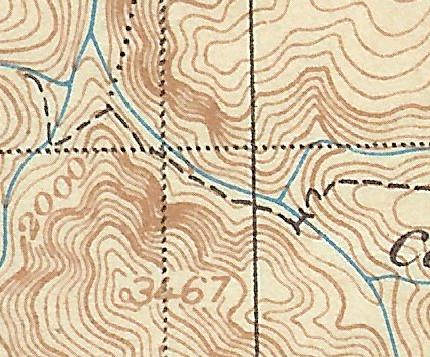
OK, I've finally found a spot on an old map that looks interesting. It is from the '38 map, which is posted here, in the section that says ClackamasDistrictMap-38.
This section is from one of my favorite areas in the district. I have no idea what this trail is named, but it would be an interesting place to visit:
R
I'll give a little more hint - the creek you see in the map is a pretty major creek that comes off the Main Clackamas river
D
I am guessing not looking at the map that this is the confluence of Fish and Wash Creeks and the trail is old 519, Cold Springs Trail.
Zack would know, having been there.
D
R
You are correct! I'm guessing that part of that trail is now covered up by the decomissioned road. So now you can post a photo or a map segment for others to guess.
D
Donovan said:
Donavon Don't we use part of the Cold Springs Trail to get up to Fish Creek Mountain from the south? Don
I am guessing not looking at the map that this is the confluence of Fish and Wash Creeks and the trail is old 519, Cold Springs Trail. Zack would know, having been there. D
Donavon Don't we use part of the Cold Springs Trail to get up to Fish Creek Mountain from the south? Don
D
If nobody else wants to post a trail I will. This is a trail I have not been on, but I have seen it on the old maps. I have looked for this trail once, but didn't have any luck finding it. This is a portion of the '38 map that shows a major trail heading north and south and some minor trails going out to the east and west. The trail that I was interested in was the minor one going to the west.
D
It looks like Fawn Creek at its confluence with the Clackamas, just south of Rhododendron Creek.
D
Doug you are correct, it is the Fawn Creek Trail.
Like I said, I looked for it once last year when I was in the area working on other trails. I looked above the road and didn't have any luck. Next time I think I will come from the bottom of Fawn Creek and work my way up. I know the road is going to take a chunck out of it, but it would be nice to locate it anyhow.
Your turn to post a photo or a map segment of a trail in our district.
Don
D
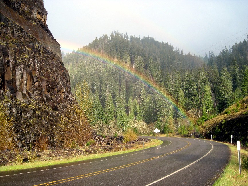
Okay, I know that this is not a trail, but it is a route to a trailhead. And I thought that this scene was kind of in the spirit of Easter and springtime. I took the photo last Thursday afternoon. Can anyone tell me where this is?
D
Doug
That is the road cut just past Fish Creek on Hwy 224 and the end of the rainbow looks like it is touching the Clackamas River Trail.
Don
R
That kind of looks like the turn on 224 right at the Fish Creek road turnoff? I was there today and it looks familiar...
Log in to reply.