
What trail am I on? Spring 2013 edition
K
Donovan said Is there a spring nearby, behind you? Don2Well, there was a rather wet area behind me as a matter of fact. I didn't really notice if it was a spring though. I'll have to explore it more thoroughly next time I'm in the area!
D
Are you on the Hillockburn Trail on the eastside of the South Fork of the Clackamas or whatever they call that trail? I have been on it once from the top down, not from the bottom like you guys have been exploring it.
Don
K
Yep, you've got it. We didn't make it too much farther after crossing that wet area Donovan mentioned.
Your turn! 
D
 I guess I should check this webpage more often. This photo was taken from a current district trail.
Don
I guess I should check this webpage more often. This photo was taken from a current district trail.
Don
D
That looks like a Cripple Creek kind of a mess.
I think there are a couple of sizable areas of laminated root rot up there.
Don2
D
It isn't the Cripple Creek Trail. A hint, this photo maybe 3-4 years old.
Don
D
Clackamas River Trail.
Did we fix that? I can't remeber.
Don2
D
The CRT it is. That photo was 3-4 years old. Eric and another faller cut that out. They had to get a waiver from the USFS for it was in the new wilderness section near the bridge access trail on the Indian Henry end of the trail. I was really scraping to find a photo of a current trail for most of my new stuff is all from abandoned trails.
Your turn to post one.
Don
D
That's right. I remember now.
I was surprised it was taken care of.
That would have been real dangerous with a crosscut, that's for sure.
Looking forward to a few forays once you snow chasers report all clear.
Don 2
D
That was one of the few surveys I ever done, having cracked my left wrist on a fall down Cougar Creek, I was off work from my day job for a month and needed something to do. I hiked the CRT and took pictures of all the damage from the storms; log bridge took a direct hit and needed replacing, dozens of big trees come down on the trail, like those near Three Lynxs like I posted.
Where are you thinking of foraying this summer Donavon? I retire the end of June, so I will have time to do more hiking or exploring in the district then I have had in the past.
Don
D
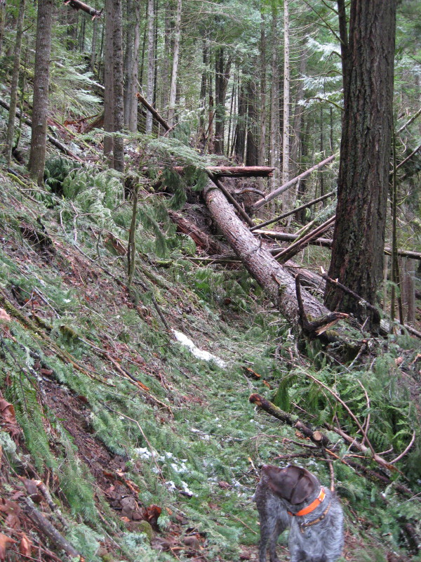
Here is another picture.
What trail am I on?
 As for where to go, I think we will have a Cold Springs West tour.
Don 2
As for where to go, I think we will have a Cold Springs West tour.
Don 2
As for where to go, I think we will have a Cold Springs West tour.
Don 2D
It looks like you are at the top or summit of the hill and there's a lake. Summit Lake.
Don
D
That's a pretty good surmise, but alas, incorrect.
The ridge in the distance leads to a prominent location.
Don 2
D
Prominent like a fork in the road or what? I have no clue where the F*#% you are?
A little more clue as to where you are maybe needed for I haven't heard of anyone else beating down your door on this one. I know, they are all enjoying the present weather pattern and are all out hiking this weekend. I wish I was, but I had yard duty this weekend. But watchout next weekend, for I have joined those who have retired from work, come Friday. Then I won't be looking at this screen, for I will be where the power cord can't reach. Out on the trail.
Don
D
That'll be good. You can get us some fresh new pictures!
The prominent location was a look out site.
Don 2
R
That lake doesn't look familiar to me at all, and that is a strange lookout site. That hill looks pretty flat. Without more clues, I'm clueless.... (as usual) 
D
The look out site is a ways to the left along that ridge behind the lake.
The lake is the shortest triplet.
Don 2
K
The look out site is a ways to the left along that ridge behind the lake. The lake is the shortest triplet. Don 2
Like how short? Say... 4,104? 
D
Sounds like you have a lake in mind.
Don 2
K
Any idea how these "triplets" got their name? Were they named after a person, or some distinguishing feature?
Log in to reply.