
Abandoned Trail on East side of South Fork - Memaloose Trail?
R
K
I was really surprised that most of this abandoned trail is in really good condition. It looks like it's had a little bit of maintenance over the years. Rob and I threw and pushed what we could off of the tread. And got rid of some of the vine maple face slappers.
It was interesting to see the difference in the sizes of the trees in this area. Some of it was due to geology and some due to fire history, I suspect. The best part of the trail was on gently sloping ground with younger trees, which is unusual for an abandoned trail. I suspect this area burned some time ago because there were some very large living trees at the edge of the younger stand. Some of these giants had burned bark on one side up to about 80' above the ground. I don't remember ever seeing living trees with that much bark that was burnt.
Do any of you guys know the fire history of this area? 
D
Did you guys notice the dwarf forest? After the stretch along the rim in the rhodies, you turned left through a deep moss floored woods of old little trees.
I think the big fire was 1902. Could be wrong, of course.
Don 2
K
Donovan said Did you guys notice the dwarf forest? After the stretch along the rim in the rhodies, you turned left through a deep moss floored woods of old little trees. I think the big fire was 1902. Could be wrong, of course. Don 2Yeah, it was right after the small patch of salal where you couldn't see your feet because it was so thick on each side of the tread. It took us a minute to regain the trail in that little moss meadow. It was kind of strange how the trail segments were so straight in that section after zigzagging up the hill, and that there weren't really any trees or shrubs that had sprouted in the tread. Maybe this trail hasn't been abandoned as long as some of the others in the district?
P
Hey Rob,
That's a really neat find - got a GPS track?
--Paul
R
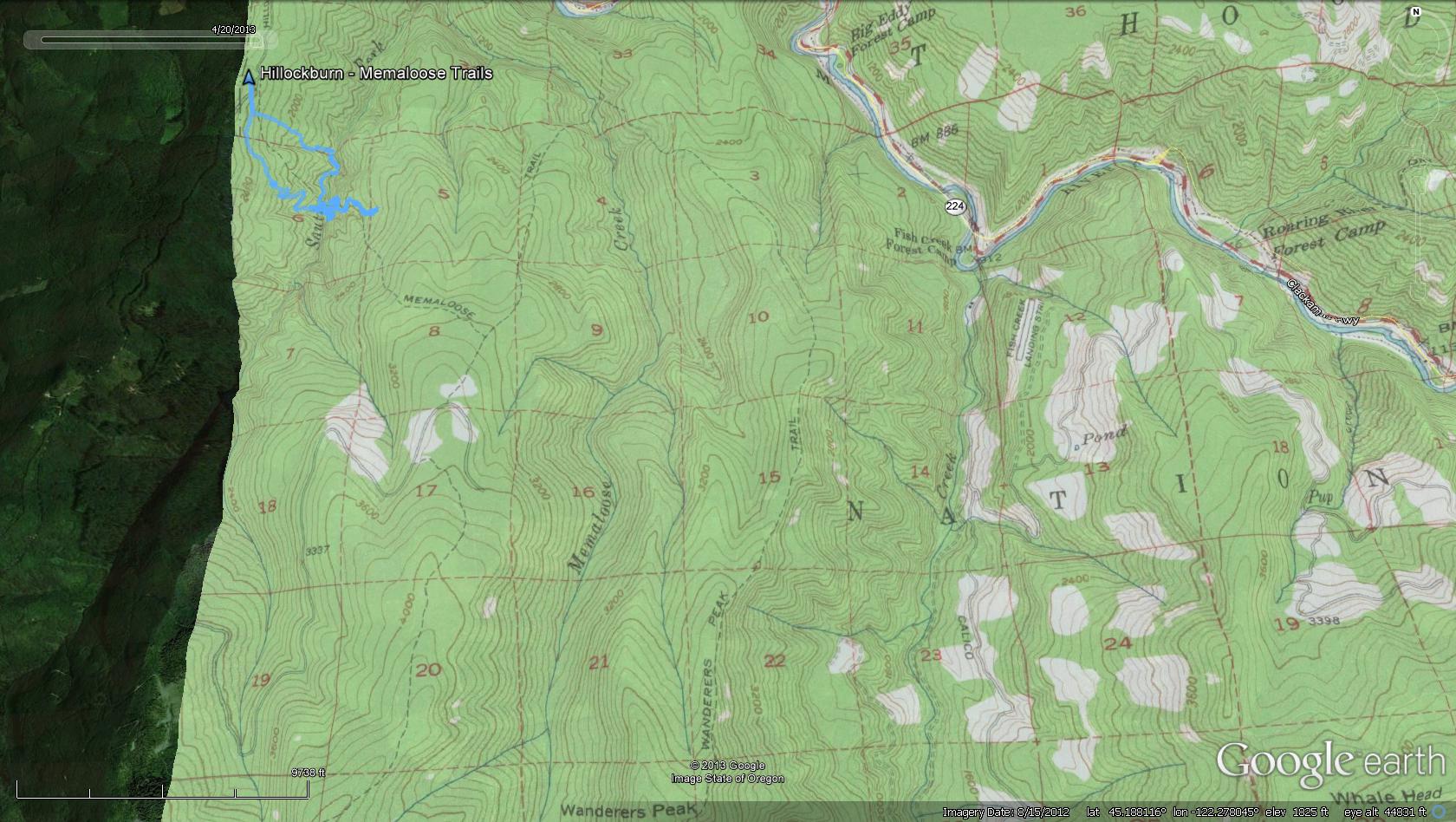
Paul Turner said Hey Rob, That's a really neat find - got a GPS track? --PaulSure - But it is a little wandering at the start. The trail is a little sketchy at the bottom of the hill due to several marshy areas. On the way up we missed a switchback and headed too far south. If you keep looking for cut logs, you will probably be able to stay on the trail. The blazes seem to start farther up the hill. You can DEFINITELY see the beginning of the trail on the other side of the river from the bottom of the Hillockburn trail. It is very evident that the trail curves north up the bank. Here is the track from the whole day: http://www.robshikingdiary.com/hikemaps/GPSTracks/2013/UpperClackamasFallsHillockburnOldMemaloose20130420.gpx I'm still curious about the name of the old trail. Is it really the old Memaloose trail? Or did it have a different name?
D
I don't think it should be called Memaloose Trail. I would make that the next trail east. Could be wrong, of course.
What I remember beginning up left to a large White Fir, then right and through the soft and under (hands and kness) a cluster of small tumbled trees to a switchback in the open but still in that bog, then back across the bog again.
I am glad you all went up there.
It is easy to follow once you get up that speep ramp out of the hole with the big timber. The logging didn't compromise the tread much at all. I am sure it could use picking up again tho.
Don2
R
Chalk up another mistake on the '56 map.....
Your memory is very good (as usual).
The tread is in GREAT shape once you get out of that boggy area down low. About the only problem areas are a few areas of blowdown. There was one in particular through a rather boggy area where there was some BIG trees down - that was a little tough to get through, but the flagging was of great help.
It was a blast to hike that trail. It needs some help to bring it back - the trees in there are too nice to let this one revert to nature! I want to go back and go from the top end. I don't know if those spur roads are still open, but it looks like it is only about 2 miles off of the 45 road up to the point where it looks like it meets the 242 spur. If those spurs aren't gated or decommissioned, you should be able to get pretty close to the upper part of that trail. That will be a trip for another day.
P
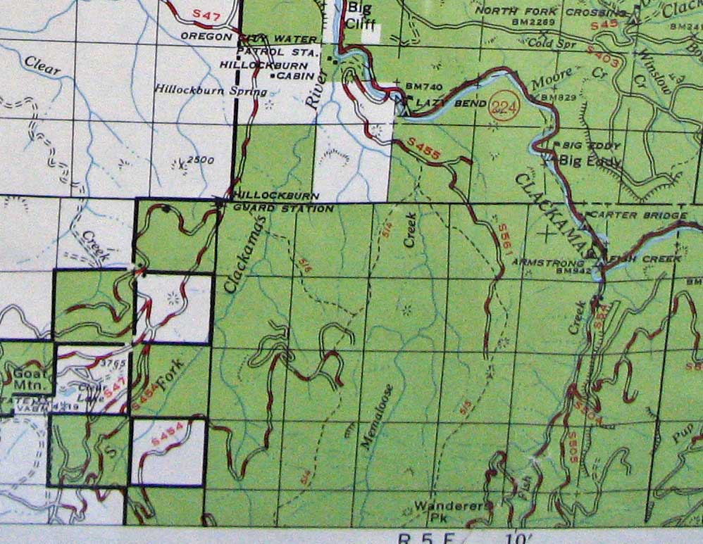
Rob Williams said Chalk up another mistake on the '56 map..... [...]Hey Rob, I've been looking at your track in GE - that was quite a day. Confusing map labeling - the 1963 MHNF map has pretty the same set of trails but numbered such that there is no ambiguity. Below is your track in blue and the 1956 map in GE. Looks like they got the trail in the general area. The next map fragment is from the MHNF 1963 map with numbers that sort of corresponds to today's designations except it has Wanderers peak as the 515 which from the trail index is Memaloose.
K
That last little bit where we took a turn to the east felt wrong to me. I think the trail may have continued in a more southerly direction before the roads were built.
R
Yea, it was quite a day - my body is just now recovering....But it was a good day. You would have liked the trip - lots of up and down and bushwhacking. But the neatest part is the scenery - the falls are now officially my favorite falls, and the trees on the east side were magnificent.
I think the current Memaloose trail is the end of the old Wanderers peak trail (515). On the MHNF map, this trail shows as the continuation of the Hillockburn trail. I wonder what the 514 trail was called?
B
Nice trip Rob. Glad u made it to the falls. Ambitious day! That old trail really deserves to be saved. It's also close to home, so having it as another hiking option would be great! My summer list is pretty empty, just hopefully getting to the Cold Spring trail, and now this one.
Do you think one guy by himself could do some good with a day or two of dedication on that abandoned trail? I'd like to follow your flagging and brush this baby out up to the top where it's always been thick
R
I think you could do a lot of good in a day or two, however to make the trail truly easily hikeable again, it will require big labor (LOTS of BIG downed trees). While using hand tools will help with a couple of brushy areas, and you could probably do some tread work in a few places, the big need is for someone with a chainsaw - although it appears this is in the South Fork Clackamas River Wildnerness area, so it will have to be done with crosscut saws..... I wanted to hike the full length of it later this year and explore that old spur road to see how far you can drive it.
B
Sounds good. The new wilderness is a blessing and a curse. It's good that this spot won't be logged again. But not having a chainsaw is gonna make it 25 times more effort to get a good amount done. A chainsaw is sorely needed. When I get Saturdays off again, I'm gonna spend atleast one day down in there.
How far up/downstream from the Hillockburn trail is the closest log suitable for crossing on?
R
There was one very close upstream, but it was at quite an angle. There was also one almost right at the crossing that you might be able to use, but the far side was a little ways off the ground. We opted to go a little downstream (200'? I'm a bad judge of distance) to a good sized log we scooted across on. It was pretty easy actually.
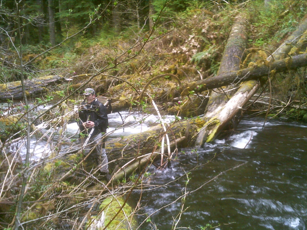
Here is the view of the log from where the trail hits the river:  If I remember correctly, we opted for the log in the distance (the second one back). It was larger and less of an angle, but still above the river.
If I remember correctly, we opted for the log in the distance (the second one back). It was larger and less of an angle, but still above the river.K
Here's a picture of Rob after his successful return to the west bank of the river:
 I think we crawled/scooted across (it was very slippery on that log) to that smaller log, crawled over, went a little more and then dropped down onto the large rock in the river. Then we scrambled to the east bank and went south to get back to where the trail crosses the river.
I smelled very earthy, like the forest floor, by the time we were done that day. I picked up a few bruises too, from scrambling over, under and around all the obstacles we encountered.
I think we crawled/scooted across (it was very slippery on that log) to that smaller log, crawled over, went a little more and then dropped down onto the large rock in the river. Then we scrambled to the east bank and went south to get back to where the trail crosses the river.
I smelled very earthy, like the forest floor, by the time we were done that day. I picked up a few bruises too, from scrambling over, under and around all the obstacles we encountered.Log in to reply.