
Granite Peaks
Greetings, Advocates!
I'm researching the trail history in the Granite Peaks area, and am hoping one of the experts here can fill in some of the blanks. First, I am a bit surprised to see that the only routes in the vicinity of the peaks, proper, were the old transect trail on the north side that has more or less been replaced by Road 6310 and a secondary trail up Buckeye Creek. These routes can be seen on this clip from the 1938 topographic map of MHNF (along with the lookouts on Burnt Granite and Mt. Lowe, and the associated trails and wires):
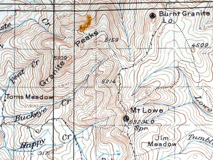
Given the rugged, prominent nature of Granite Peaks, I'm surprised there wasn't more activity — or perhaps even a lookout — back in the day. The peaks form a fairly high ridge (four of the summits crest 5,000, and are only about 100 feet shorter than Mt. Lowe) and the area to the west drops off to the broad Collowash-Clackamas confluence, with Fish Creek Mountain the next major peak to the west.
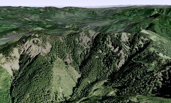
This can best be appreciated with a Google Earth view of the Granite Peaks, looking to the northwest, with Fish Creek Mountain on the left, the Silver Star Range on the far right horizon and the flats of Portland on the horizon, center — lots of visible forest terrain in-between that presumably couldn't be seen as well from either the Burnt Granite or Mt. Lowe lookouts:
I haven't explored the peaks on foot, at all. So, while I'm skeptical about the geology actually being "granite", I am wondering if there are some igneous formations that might be similar to some of the stuff in the Bull of the Woods and Opal Creek areas… and if so, whether there might have been mining in the area that led to the naming of the peaks..?
BTW, the backstory on my research interest is the USFS proposal to decommission a bunch of roads in the area, and in particular, access to trails and trailheads that might be affected.
Thanks in advance for any light you can shed!
Tom Kloster
Tom
I have done some exploring in the upper reaches of Buckeye Creek near the 6310 road, but haven't found anything conclusive otherthan a game /access trail coming up through a low pass on the ridge south of the Granite Peaks. Someone had recently in the last year or so cutout some of the logs the were across the trail that leads down into some meadows south of the peaks. Not sure if it was for a wildflower study, for the area is rich in plant diversity, or some hunters or other users in the area.
Most of all of the spur roads put in to log the peaks area have already been decomissioned and I am sure other roads in the area are earmarked to be also. The lower Buckeye Creek area looks like it has seen alot of disturbance from the logging and roadbuilding and I am not sure if there are any traces left of that trail coming up the creek or not. Like I said I have only looked up on top and haven't explored the bottom end.
Don
Thanks, Don -- I'll have to take another look to locate those meadows. I'm eager to get up there... already starting my summer hiking plans!
I did check the geologic maps, and though the area is pretty generic for the Cascades (the Granite Peaks are, in fact, largely andesite, and Mt. Lowe and Burnt Granite are overlying basalt), the complex of peaks is mapped as a composite volcano, centered on the north pair of Granite Peaks. This is quite unique, as Mount Hood and Lookout Mountain are the only other peaks in the MHNF are mapped as composite volcanoes. Everything else falls into the small volcano category (shield volcanoes, andesite cones, etc). So this makes the Granite Peaks complex quite unique -- more like the High Cascade volcanoes in origin than most of the surrounding peaks.
Okay, enough geology..!
I hope I don't smell yet another damn wilderness.
Or what I meant to say is, there's nothing there of any interest that I know of.
Donovan
Not that I'm aware of - just an opportunity to undo some of the logging road system where it never should been built. In this case, the Collawash watershed is the focus, and thus this particular corner. But the USFS is doing the proposals, and they're being quite bold in what they proposing, too.
This is a watershed event (no pun intended) for the MHNF that is surprisingly below-the-radar, given the decades of warring over roads and logging. I give them (the MHNF) credit for trying to figure out what a minimum level of service roads looks like in scaling back the system to some sustainable level.
It's important to weigh in where trails are affected, and especially where roads can be converted to become trails as part of the road closure process. Anyone interested in this can look at the "current projects" area on the MHNF site, and download maps of the proposals under the "Collawash Road Decommissioning" heading.
Tom
It will be June or July before you get up on top, at least that has been my experience. I have always wanted to hike across the southside of Granite Peaks with all those unusual rock formations. Now it kind of makes sense it being a volcano, with the north rim still there. I haven't looked at a geological map of the area, but now you have renewed my interest.
Road Decomissioning
Wow. I took a look at a few of the documents, and there are some "major" (not spur) roads that are marked for "Decomission with delay (5-10 yrs)". I'm guessing that means they won't be decomissioned now, but will be in 5-10 years? I'm wondering what would determine whether it would get decomissioned in 5 years or 10? How do they determine when it is time to decomission it?
Pretty much all of roads 6311, 6320, 6330, 6341, 6344, 6370, 7010, 7040 are marked for being gone in 5-10 years. Getting rid of all of the little spur roads makes sense, but some of these roads seem to be the only road in the area. For example, 6341 would disappear shortly after the Pansy Lake trailhead, but it continues along for a quite a while up the valley.
It also appears we would lose access to the Baty Butte trailhead, as the 7010-160 spur would disappear.....Maybe they think we can access it from the other side. There are probably others that I haven't seen, since I just took a quick look this morning.
Rob, the scoping letter posted with the maps lays out their objectives as follows:
- Reduce impacts to water quality and aquatic habitats associated with unneeded roads.
- Reduce road density to improve terrestrial habitat utilization.
- Reduce the spread of non-native invasive plants associated with unneeded roads.
- Reduce road maintenance costs.
The first and last bullets are the drivers -- and especially the last one. At this point, they've got such a huge maintenance backlog, and no new revenue source in sight, that this was sort of the obvious outcome. What surprises me is that they're actually decommissioning (or proposing to) a number of roads, and that costs money.
I suspect their scientists are telling them that simply closing the roads will leave them vulnerable to collapse in steep terrain, making matters worse in already heavily impacted areas -- and possibly putting them in violation of the ESA if known salmon and steelhead habitat is destroyed through lack of preventative action.
As far as the delay, I don't know the official answer, but I suspect they still have timber sales to deliver on some of the route, or perhaps are planning salvage and thinning operations in some of these areas. In other areas where they have already gone through this process, some roads in the final action were simply left "closed" -- meaning gated or barricaded and not maintained -- while others were "decommissioned", and you've probably encountered one of those.
BTW, to the credit of the USFS, they do appear to be trying to maintain trailhead access in most cases, and this round of maps is a BIG improvement over those covering the Upper Clackamas, earlier this year. That set included no trail information, and no landmarks except streams, which made for a tedious review. I think they heard from a number of us who commented, and improved the maps this time.
They released a similar set of proposed closures/decommissions for Wildcat Mountain and north side of Zigzag Mountain last fall, in similar fashion, so they are covering a LOT of ground.
Tom
Back to Granite Peaks, here's a clip from the geologic map - this is very small scale, so I've included the Collawash/Clackamas and Timothy Lake as references. The Rock Lakes Basin also jumps out on this map (with a couple volcanoes mapped on the little divide between the Cot Creek and Shellrock Creek drainages).
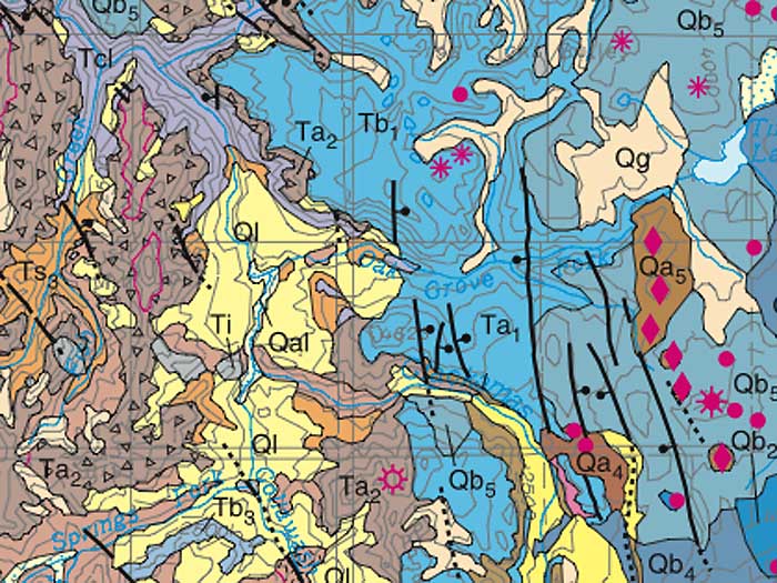
The "Ta2" symbol is right on top of the Granite Peaks (and the designation refers to Tertiary Andesite). The symbol of an open circle with radiating hash marks denotes a composite volcano. At this scale, the fact that it's centered on the ridge just east of the main Granite Peaks crest isn't as significant as simply having the group of peaks identified as a composite volcano.
That means the geologic studies points to a potentially much larger peak here (probably like one of the smaller Cascade Crest volcanoes, like Ollalie Butte). The "Qb" symbol denotes younger basalts to the east, and the "Ql" (yellow areas) are younger landslide and debris flow formations. I suspect these surrounding features were part of the conclusion that Granite Peaks/Mt. Lowe are the core of a much larger volcano -- plus likely research on road cuts in the area.
Okay... enough geology... again!
Tom
Tom Kloster said:
The first and last bullets are the drivers -- and especially the last one. At this point, they've got such a huge maintenance backlog, and no new revenue source in sight, that this was sort of the obvious outcome. What surprises me is that they're actually decommissioning (or proposing to) a number of roads, and that costs money.
That surprises me as well. I don't really understand how ripping up a road will make it any different than an abandoned road. If the road were paved I can understand, siunce you are removing the hard surface, but for a gravel road, it seems all that happens is that the surface becomes VERY uneven. Water would still percilate through the road the same way it seems no matter whether it were ripped up or abandoned.
If they were actually able to do more work (i.e. grading and brushing) of the existing roads, I wouldn't be averse to removing some of the "other" roads. What bothers me is roads that have become so washboarded they are tough to drive on, or they are so brushed in, you can't drive on them unless you want to scrape up your vehicle.
Well, my take on this (again, just speculation) is that there are two levels of "decommissioning" that could occur. One level is to simply pull out the culverts and remove fill from the stream crossings, allowing the natural drainages to function unimpeded. The next level is to destroy the road surface between stream crossings, and this is where a road can become a trail. The difference, IMO, is that the full decommission removes open drainage ditches along all portions of a road, and begins to restore the natural runoff profile -- and this is probably an important step in prevent road fill failures that lead to slides (from channeled runoff). A decommissioned road probably re-vegetates more quickly, since the surface left behind is a very loose and friendly to plant growth. That's my take on it, anyway.
A good example is the first mile of the Ramona Falls Trail, which used to be road but was converted by basically running a backhoe along one track, and leaving a long pile of boulders and loose soil next to a smooth trail on the intact road track. This is an important distinction to make in commenting on the MHNF proposals, since a decommission contract probably wouldn't be much different, whether the contractor is retaining a portion of the road grade, or not.
The examples I've seen of a conversion generally retain the downslope track in sloped areas, I suppose with the idea that loosening up the road bed in the uphill track is a step toward the cut slope eventually filling in to the narrow trail grade. Because of the relatively gentle grade, these would make excellent bike trails -- I know the mountain bike advocates are watching this pretty closely for that opportunity.
Log in to reply.