
Road 57
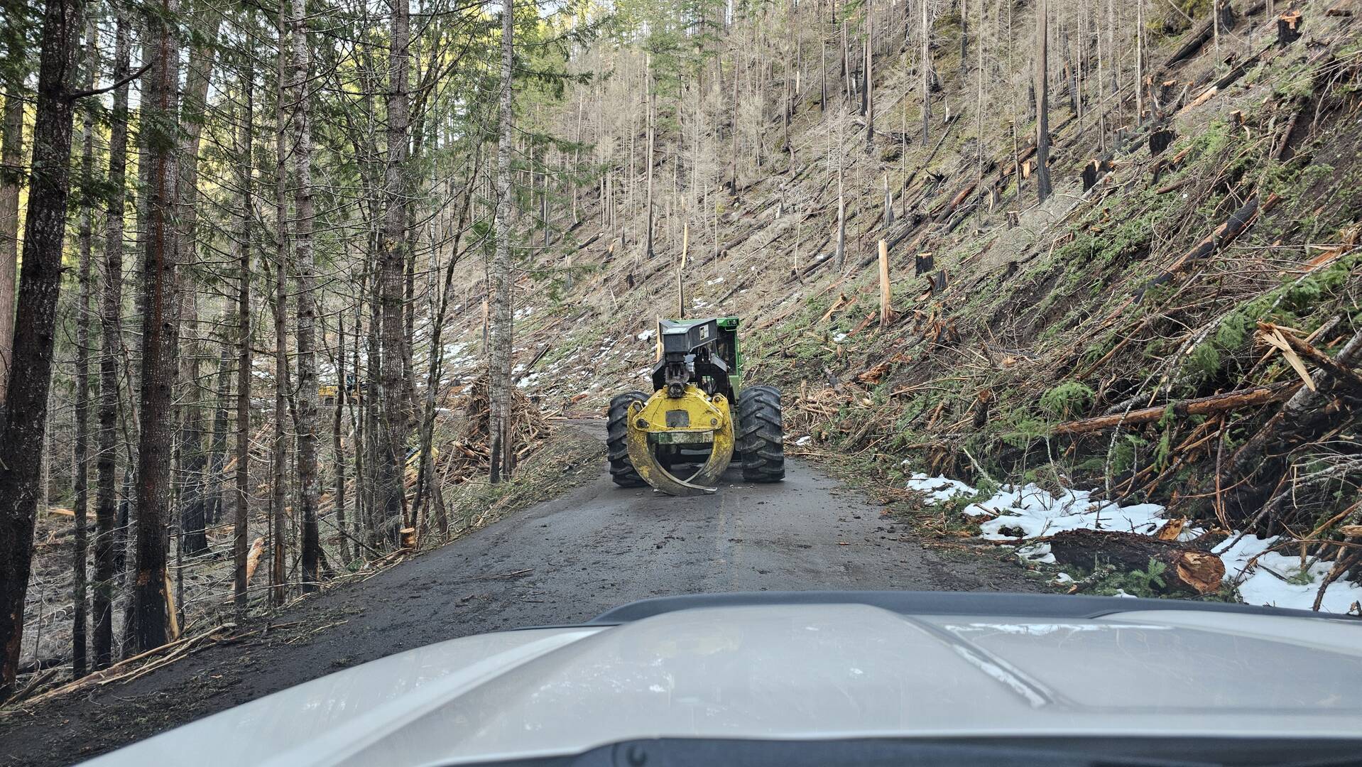
I was out yesterday and noticed that the gate to road 57 was open. I drove up the road about 3 miles before having to turn around due to the road being blocked by heavy machinery. Those first 3 miles are being HEAVILY cut out, but most of the cutting appears to be done so hopefully it will get cleaned up and finished soon so they can re-open the road. There were a few other curious souls who had driven up the road as well.
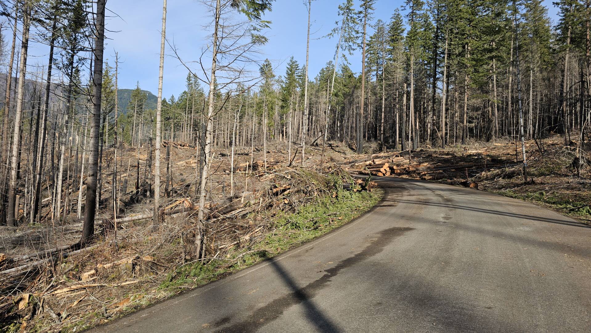
I think they needed to replace 2 or 3 culverts as well. I stopped asking about this since they've missed every timeline they previously stated.
Mt Hood also just mentioned on Facebook that the contractor said they were halfway done with tree work....
And the contract allows them to work all through 2024. Sigh.
Half way done? We were able to drive just about to the edge of the burn and they cut like crazy. If they are only half done they are nuts...... I guess we will see when it opens, just like everywhere else has been. I'm just astounded at how long all this has taken.
Yea, maybe it's like 224 when there initial estimates were to cut all the way up to the ridgeline and then they adjusted and didn't cut anywhere close. I can't figure it all out and why it would take months to put in a couple culverts. I also heard they were done cutting up the Sandstone Road but have no idea what plans are for opening that road again.
57 and 4630 roads are now open (kinda sorta)
I made it up to Olallie Thursday night. The 4690 road after the pavement was a little rougher than last year, but not as bad as it was before the fires. Went in to Russ Lake, and there were a few snowbanks on the trail. Also went to Lower Lake. Same as last year.
I heard from a gentleman that I spoke with at Olallie that 57 was “open” but not officially. He said he had heard tales that it was now a "low priority" for law enforcement. Friday he had been up 57 to Shellrock Creek road (58) and went up, but was he was not able to make it all the way to High Rock as he had originally intended. Snow stopped him about 2/3 of the way up from the Hideaway turnoff.
After my trip up to Olallie lake, I was on the way back down from Olallie, and so I went up 57. I went up to Lake Harriet. It was very full and populated with folks camping and fishing. It was free fishing weekend, this makes sense.
At Harriet, the new change since last year was that the road (4630) to the dam and downstream, now has had the barriers removed. Of course, I had to go down to see just how far it was open. I made it down to the Skunk Creek / 4635 road that goes “up the hill”. The road up was open, but I noted a new “green gate” (was open). As much as I wanted to, I did not go up today, perhaps next time. I continued, and went on the road that goes down to Ripplebrook. I hoped to not have to backtrack, and I had a gut feeling that I would not make it out via Pipeline / Three Lynx. Sure enough, I was able to exit to 46 next to the RS. There was no gate but maybe a sign that said something about like being closed, right? As I went back to town, I noted that the gates at the bottom of 4631 and Three Lynx were still shut, just as I expected.
So, apparently, we can now go up via 57 to Harriet and down (or perhaps via Ripplebrook road?) and get access to the road up to 4635. A few years ago (before the fires) that road was always in bad shape, especially up on top and around the corner, with all the blowdown from winter. I am wondering if we can now make it to the Rimrock Trailhead, and Cache Meadow. I really like that area and wonder about the burn effects up there.
Thanks for posting this. The gate at 224/46 has been open for a while now, but last time I drove it (over a month ago), the gate on the far end was still closed, even though it was thru the fire area. I'm interested to get back up 4635 again as well.
Cache Meadow did not burn, however a relatively small portion of Rimrock burned. I hiked Rimrock from the east end a while back and a small portion near the west end burned somehwat. It isn't terribly bad though.
I also meant to ask how much snow was at Olallie? The modeled snow depth maps still show a fair amount of snow at the lake and the road in (4220). Maybe the models are wrong? They aren't perfect but I've usually found them to be pretty good, usually erroring on the side of caution (meaning they might show a bit more snow than reality).
I had today off, so I decided to see if I could get up the 4635 road to hike the MP3 trail. Good news! I went up 57, then back down 4630 towards Harriet Lake. They paved the road thru the lake area, which is really nice - keeps down the dust a lot. I continued past Harriet Lake and got to the junction of 4630 and 4635 - the road was cut out about 5 miles up, but at that point there are some logs across the road, so the Cache Meadow/Upper Cripple Creek/West Rimrock trailheads are still not accessible. I did cut out one log but then encountered the next blockage and since it was just me I turned around. I was able to get to the MP3 trail with no issues. On the way home I thought I'd roll the dice and see if I could come back pipeline road. On the way in the gate at Three Lynx was open but there was a sign saying "gate closed" (which seemed a bit odd, but I figured it was a warning that the gate might close at any point). I figured if the gate was closed I would just go back the way I came in. I was able to drive all the way down pipeline road, thru what used to be Three Lynx and back onto 224. They've cut out all the "hazard" trees on pipeline road, so I really don't understand why it is still closed. There was also a gate on 4630 at the junction with 4635 but it was open as well.
Things look quite a bit different than they used to on pipeline road. Unfortunately, it doesn't appear they've fixed the trailhead for the Cripple Creek trail next to the pipeline above Three Lynx. The trail got pretty much obliterated up to the first switchback after they cut the road out. The sign that was there is gone as well - I'm wondering if the Forest Service is just going to abandon the trail. That would be sad because that is/was a great way to get up into the snow in the winter.
The FS has posted a notice that Rd 57 will be closed off and on for culvert work starting Jul 8 although they don't say where the culvert projects are located. The good news, though, is that Rd 4631 is now open at Ripplebrook for access to Lake Harriet and presumably Rd 4635. They don't say anything about going beyond Lake Harriet. I wonder if we can continue on Rds 57 and 58 to Shellrock and Hideaway Lakes or if that part of Rd 57 is included in the closure.
https://www.fs.usda.gov/alerts/mthood/alerts-notices/?aid=88620
The notice I saw said that the closures will be limited to 30 minutes or less - but going either Pipeline or 4631 seem like the best option. I'm very sure you will be able to continue up to Shellrock/Hideaway/Rock Lakes on either of those roads. I remember years ago when 57 was closed for a couple of years - 4631 was the bypass.
The work area is only within the burned area - I'm 99% positive of that.
Well, I guess it depends on which notice you read - I just saw this one which says they will only open the road 4 times a day during the week -
Traffic will be allowed to pass through at 10 a.m., 1 p.m., and 3 p.m.
It starts next Monday, July 15th and will be from 7am - 5pm Monday - Friday. Given that the notice is dated until Sept 1st, I'd guess they will be doing this for the next 2+ months. The good news is that you can take 4631 to go around it. It will be a bit dustier and slower but it should work fine.
FYI, I see I just posted the same link you did earlier..... 😳
Log in to reply.