
Key Stats for Whetstone Mountain Trail - 546
About
A Trail Pass IS NOT required for this trail
Note: The route shown on the topo map below (and the GPS track) shows the route all the way to the top of Whetstone Mountain which is actually part of the 3369 Trail. The 546 Trail goes from the 7020-028 road east to the Bagby Trail. Where the route intersects the 3369 Trail and heads West is part of the 3369 Trail.
A thousand foot climb over two miles leads to an awesome open view of the heart of the Old Cascades and many of the new volcanic peaks along the new crest. The footing in the last mile to the summit via Willamette NF Trail 3369 is not real good.
Heading east to Silverking Mountain, the travel is fairly easy, most of the climbing to the ridge in the first mile. There is no water along the ridge. A nice campsite is located about a half mile east of the Battle Ax Creek trail junction (3369). Footing towards the east end of the trail becomes poor traversing a south face of an un-named peak just before the junction with the Bagby Trail – 544.
Many people use this trail to access Twin Lakes, a popular overnight destination. It is also a relatively easy way to get to Silverking Lake.
This trail runs the divide between the Santiam and Clackamas drainages along the ancient “Mollala trail”. The 3369 trail dropping off this ridge to the south is the responsibility of the Willamette National Forest. It is also referred to as Whetstone Mountain Trail which makes things rather confusing. It is listed on this site as the Gold Creek trail.
A long abandoned and extremely difficult to find segment of this trail runs west along the divide to Burnt Mountain where it then ran north to Baty Butte and beyond via Baty Butte Trail – 545. Over Nohorn Butte, a route ran towards Table Rock.
Directions
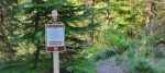
Travel Hwy 224 thru Estacada to Ripplebrook. Continue thru Ripplebrook and immediately after crossing the river, continue straight on Forest Service road 46. Travel approximately 3.5 miles on road 46. Turn right at the junction with Forest Road 63. Stay on road 63 for approximately 3.5 miles and turn right on Forest Road 70. Travel approximately 7.4 miles on Road 70 to Forest Road 7020. Turn left on Road 7020 and travel approximately 7 miles to Forest Road 7020-028 (approximately 0.1 mile before the end of Road 7020). Turn left on Road 7020-028 and drive to the trailhead. The trailhead is on the right. There should be a sign.
Map and Elevation Profile
Trip Reports
| Photo | Date | Report Summary |
|---|---|---|
 |
Oct 10, 2022 |
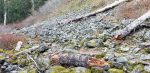
Fires did a number on the trail
Hiked this trail from the trailhead on 7020-028 – The beginning of the trail is intermittently brushy but not bad. When you enter the burned areas, there are significant areas of downed trees and lots of fireweed. Portions of the tread are difficult to follow due to all the weeds and brush and in some cases the tread has disappeared completely. I...
|
 |
Nov 9, 2019 |
Great views from the lookout but a bit brushy
Hiked this trail from the trailhead to the old lookout site. Trail is in pretty good shape, but has quite a few downed logs on it. Easy to hike this time of year – in the summer if might be a little harder due to brush in some areas.
|