
Key Stats for Baty Butte Trail - 545
About
See Thunder Mountain Trail 543 for one map showing the relationship of this trail to 542 and 543.
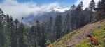
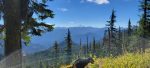
Officially only a mile long trail skirting Baty Butte this trail actually continues some six miles along the Molalla-Clackamas divide running south beyond the powerlines and then down to Joyce Lake. Sometimes it is referred to as the Boundary Trail. There are two access points north: Lost Creek Meadows and the northmost point on the 7010-160 spur. As you drive up the 160 spur watch for Baty Butte — a distinctive white “beard” on it’s south face* — and as you turn away from it there will be a long abandoned deck of logs on the right. The trail is just over this deck. There is no real parking spot except for squeezing in off the road. This is a segment of the old South Fork Trail, formerly a first class route from Estacada to Bagby Hot Springs. The Lost Creek Meadows trailhead is on the right in a level stretch of road shortly after the end of the climb up the hill. There is room for a few rigs to park on the left. Two south access points are the powerlines (a wild flower paradise) at the crest of the ridge and at Joyce Lake left at the entrance to the lake (not at the lake!) at Joyce Lake Road (BLM). A powerline access road leads up to the crest of the ridge. Trail runs both directions along the ridge from the clearing.
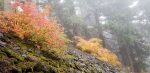
Trail is maintained by users. The north three miles of the trail are better maintained than the south end. There are no signs. Trail survives by virtue of its scenery, wild flowers, and views. There is usually a breeze. An historic trail well worth investigation. Frequented by hunters in the Fall. Biologists have some interest in the flora. The route is not particularly strenuous.
Two bad spots prevent smooth passage. Climbing out of the lake the trail ends at BLM clearcut just before a saddle. Scamper up the scree slope here and regain the trail at the north shoulder of the saddle where the cutting ended. You will now be heading north.
Another logged over stretch, a Forest Service partial cut, is about a quarter mile north of the powerlines. Continue at the same elevation to find the continuation of the trail north at the other side of the harvested area. Kind of tough stretch. Nice berries in August. There may be flags to show the route.
Trail shows on the older topo maps. Has been deleted from the new edition.
The switchbacks into Lost Creek are impassable but do deliver you into the midst of an incredible bounty of salmon berries.
Minimal water, if any, along the route. A dribbly spring is located about a half mile north of the powerlines. Another one is at the switchbacks about a mile and a half north of the powerlines in a berry patch. These switchbacks can be grown over with salmon berry thicket. If you loose the trail, head up to the saddle. The trail continues north and towards the eastside of the next highpoint.
This is a great trail with no official protection at this time. The south end needs some friends to work on it.
Andrew Jackson Baty was a farmer who lived on Dickey Prairie about five miles south of Molalla. He was a pioneer settler in this locality and spent much of his time hunting in the Cascade Range. This mountain was named for him, probably by the US Geological Survey party which prepared the maps accompanying Professional Paper Number 9, “Forest Conditions in the Cascade Range Forest Reserve”, Washington, 1903. The mountain at one time was known as Whitespot.1
1Oregon Geographic Names, McArthur, Lewis.
Directions
Travel Hwy 224 thru Estacada to Ripplebrook. Continue thru Ripplebrook and immediately after crossing the river, continue straight on Forest Service road 46. Travel approximately 3.5 miles on road 46. Turn right at the junction with Forest Road 63. Stay on road 63 for approximately 3.5 miles and turn right on Forest Road 70. Travel approximately 3.2 miles on Road 70 to Forest Road 7010. Turn right on Road 7010 and travel approximately 6.3 miles to the 7010-160 spur road. Turn right on the 160 spur and travel approximately 2.8 miles to the trailhead on the left. There are no signs. There is a wide spot on the road to park a bit south of the trailhead.
Map and Elevation Profile
Trip Reports
| Photo | Date | Report Summary |
|---|---|---|
 |
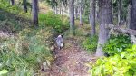
Oct 20, 2025 |
Baty-Silver King Trail – October 2025
We hiked the section from the Lost Creek Meadow trailhead down to the power lines.
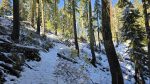
Very good overall due to recent maintenance. There are a few short side hill sections with poor footing due to treadway geometry. The corridor is currently in excellent condition except for approximately 33 logs (mostly step overs).
|
 |
Nov 6, 2024 |
Trail impacted by Sandstone fire work
Hiked part of this trail today- 11/6/2024. I was curious what things looked like after the Sandstone fire work. The bad news is that there has been some significant damage to the trail from the fire work. There was a dozer line cut from the 7010-160 spur up and it crosses the trail twice. I think they might have fixed those two crossings (it was ha...
|
 |
Aug 13, 2022 |
Amazing trail with lots of downed logs
Hiked this trail on 8/13/2022 and the previous comments are still pretty accurate. I’m sure there are a few more downed trees and parts of it are pretty brushy. The “rocky thicket of green” on that switchback is a perennial issue it seems. The cut area north of the powerlines is very rough and there isn’t much of a trail thru there really.
...
|
|
📷 |
Jul 18, 2020 |
Very quiet trail with some tricky sections
Hiked the trail 7/18/20 heading south starting from Lost Creek Meadows. Very quiet. Many logs down, most step-overs but a few big ones. Brushy but passable. There is a tricky section after the saddle following the high point the trail switches back down steeply into a rocky thicket of green, emerging on the other side where the trail bench was form...
|
 |
Oct 17, 2017 |
Awesome trail that needs a bit of help
Hiked south – was intending to get to the power line crossing but didn’t quite make it. The trail has quite a few new downed trees and continues to be very brushy in spots, but is still a fantastic scenic trail.
|
 |
Sep 26, 2015 |
North end was in great shape
Trail north of the access junction was in fabulous shape – the junction trail had some recent maintenance. Trail south of the junction is getting pretty brushy with a fair amount of blowdown.
|