
Key Stats for Pyramid Butte Trail - 740
About
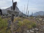
The Pyramid Butte trail is an abandoned trail that is in very good shape. There is some trail damage due to the Pyramid Butte fire in 2010, and the Lionshead fire in 2020, but the trail is reasonably easily followed once you find the correct trail junction. The trail track listed here has a waypoint with the location of the trail junction as well as where it joined the Skyline trail. Trail is more easily followed from the south end as that had less burn damage. The north end has some significant damage from the Lionshead fire. Trail is steep, but well graded. The views from the top of Pyramid Butte are outstanding. The footbridge mentioned in some trail descriptions and referenced on the topo map burned up in the fire in 2010 and has not been replaced.
Directions
Trail is not directly accessible via a road. Closest access is via the PCT access point at Breitenbush Lake. Refer to the PCT trail page for directions.
Map and Elevation Profile
Trip Reports
| Photo | Date | Report Summary |
|---|---|---|
 |
Sep 29, 2025 |
Trail is in OK shape after fires – but places are sketchy
I was surprised to see an official sign at the two junctions to this trail (north of the butte and south of the butte). It used to be you had to take an un-signed trail (the old Skyline trail route) over to the Pyramid Butte trail - now there is a sign at both junctions. The route from the north has has pretty significant fire damage and is very ...
|