
Key Stats for Dickey Creek Trail - 553
About
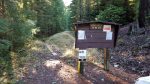
Note: The trailhead for this trail has moved from what is shown on the maps and from what is described in the old trail info sheet. The new trailhead is approximately a half mile from the old trailhead. The road to the old trailhead has been decommissioned and is now considered part of the trail.
The initial descent is very steep and can be some of the worst trail in the district. Recent work has been done to create steps in several steep sections and has helped improve this portion of the trail, however there are still some difficult sections without steps. Once down the hill conditions improve.
After enduring the initial descent, you are treated to a nice wetlands area and then a beautiful grove of old growth trees, all the while following the path of Dickey Creek. Dickey Creek is more of a river in the spring, and crossing it can be difficult during high water periods.
After the creek crossing, the trail starts uphill and goes through drier forest, up to the slopes below Big Slide Mountain, across a long scree slope. There are several nice campsites at Big Slide Lake.
Directions
Travel Hwy 224 thru Estacada to Ripplebrook. Continue thru Ripplebrook and immediately after crossing the river, continue straight on Forest Service road 46. Travel approximately 3.5 miles on road 46. Turn right at the junction with Forest Road 63. Stay on road 63 for approximately 5.6 miles and turn right on Forest Road 6340. Travel approximately 2.7 miles on Road 6340 to the 6340-140 spur. Turn left on the 140 spur and travel approximately 1.0 miles to the trailhead which is at the end of the road. There should be a sign.
Featured in 100 Hikes in Northwest Oregon
Map and Elevation Profile
Trip Reports
| Photo | Date | Report Summary |
|---|---|---|
 |
Nov 21, 2015 |
Much improved condition on initial descent
Initial descent is improved from what is described here, but still needs improvement. 15+ trees across the trail up to the creek crossing, but otherwise in good shape. One REALLY big tree down in the swamp.
|