
Key Stats for Cripple Creek Trail - 703
About
A good year-round opportunity for fun. Easy access only about a mile off the pavement. There is usually year round access to the trailhead. As the trail leads to the high country you will encounter snow at some point during the Winter and early Spring.
This is a great way to access the high country by foot rather than miles and miles of gravel road driving. The trail also clears of snow weeks before the 4635 road.
According to C.W. Elliot, civil engineer of Portland, Cripple Creek was named for a surveyor who cut his foot with an ax in the vicinity in 18971
Three Lynx has an interesting story on how it was named. Old maps show the creek called Three Links, and there is a legend in eastern Clackamas County to the effect that this name was the result of loss, by a surveyor, of three links out of a surveying chain. Ernest P. Rands and William C. Elliott of Portland, for many years civil engineers in Oregon, said there was not truth in the three links story. They were in the neighborhood of the stream at the time it was named. They are authority for the statement that one of the Austin family, early settlers nearby, named the stream Three Lynx creek because he saw three bobcats on its banks.1
Connects with several other trails once on top: Cache Meadow Trail 702, Grouse Point Trail 517, and indirectly Rimrock Trail 704.
1Oregon Geographic Names, McArthur, Lewis.
Directions
West Trailhead:Travel Hwy 224 thru Estacada. Continue on Highway 224 approximately 23 miles to Pipeline Road (signs will say Three Lynx). Turn left and proceed on this road for 1.8 miles. The trailhead will be on the left at the top of the hill. If you drive downhill at all or past the big pipeline you have gone too far. There is no sign – the sign at the trailhead was destroyed in the recent fires.
East Trailhead:Travel Hwy 224 thru Estacada to Ripplebrook. Just past the Ripplebrook store, turn left onto Forest Road 4631. Travel approximately 2.5 miles to Forest Road 4630. Turn right on Road 4630 and travel approximately 0.6 miles to Forest Road 4635. Turn left on Road 4635 and proceed travel approximately 8.6 miles to Forest Road 4635-140. Turn right on Road 140 and proceed approximately 1.2 miles to the trailhead on the right. There may be a sign here. Note: The trail crosses the 4635 road approximately 7.5 miles up the road. This is another access point.
Map and Elevation Profile
Trip Reports
| Photo | Date | Report Summary |
|---|---|---|
 |
Feb 26, 2026 |
Do not hike this trail in shorts!
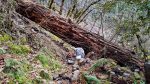
Trail burned significantly in the 2020 files. As such, trail is in pretty rough shape thru the burned areas. Lots of downed logs but more importantly has a lot of brush encroaching on the, including lots of thorny canes which are really tough to navigate in places. Tread occasionally disappears for a bit in places. The poison oak in the rocksli...
|
|
📷 |
Aug 10, 2018 |
Recent maintenance
Hiked the Cripple Creek trail from Three Lynx to Serene lake yesterday. Not sure the last time the Forest Service acknowledged the trail, but my 2003 map doesn’t show it, and it’s obviously not been maintained by the agency for a while. A good portion of the tread has slumped, making for tough hiking, but someone recently logged it out, which h...
|
 |
Feb 10, 2016 |
Trail is in good shape
Trail in good shape – 12 logs down up until the 4635 road crossing. Most were easy stepovers, but there is one large log down on one of the first rockslides.
|