
Key Stats for Potato Butte Trail - 719-A
About
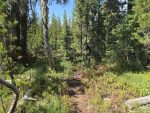
This rewarding side trail departs the Red Lake Trail at Sheep Lake northbound. There is a sign. Follow across a dry flat to a seasonal pool or meadow on the left. If there is water, skirt the bank 30′ to find the trail again. There is at this same point a nice lake and camp about 100′ to the right.
Shortly the trail begins a very steep ascent. Footing is challenging due to the cindery composition of this volcanic feature. Once you level off there is a side trail to the right leading to the “potatoes” and a fabulous view.
Continue on to the summit for a northerly view and a rest!
See Red Lake Trail.
Directions
Trail is not directly accessible from a road. The closest access is from the east end of the Red Lake Trail. Refer to the Red Lake Trail page for directions.
Map and Elevation Profile
Trip Reports
| Photo | Date | Report Summary |
|---|---|---|
 |
Sep 6, 2025 |
Post Fire Conditions
The beginning of the trail from Sheep Lake did not burn and was in pretty good shape. After the initial ascent, you enter the first burn area which is a bit indistinct. You exit the burn area near the big meadow/pond where the trail skirts the north end. Shortly, you re-enter the burned areas and the trail gets considerably worse. It gets a lot...
|