
Donald Presley said:
Paul:
I went out yesterday and explored for the Pot Creek Trail coming down Lost Creek. I found that switchback that you had mentioned and flagged both legs all the way out to the clearcut, but didn't see anything lower down. The upper leg comes out on the ridge where the slope changes from gradual slope above and steep below. I believe that the switchback is the last one going up the hill, for it is the only one that comes close to the creek and comes out above the steep slope. I built a rock cairn at the point where the trail is easy to follow down from the ridge.
[...]
It looks like the logging activity took out the tread in the clearcut, but I will probably get out there and look again, for now I know where to look. I found some phoneline on the ground out in the clearcut as I headed west looking for tread. Looks like it heads into some uncut timber again, so we might be able to locate some more tread over that way. I will have to see if I can drive up the 5720 road to get up on top. At 3000 feet, there wasn't hardly any snow left. What a difference a couple of weeks make.Don
Don,
I do not recall that segment through the rock field, that's a great find - this was first class trail back in the day. Like you point out, there may be more pieces but with switchbacks cut off by the clearcut.
The next round of decent weather I want to get back out that way - this Saturday is looking like no rain.
BTW,
In the clear cut I kept running into these objects composed of screen and a wire holder - some device to aid reproduction I suspect. They are all over the place.

--Paul
Paul,
Was the switchback you saw 1-200 feet from the creek? We may have seen different ones.
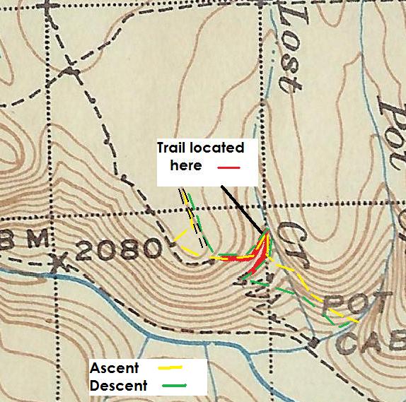
I don't have a GPS. So this is my rendition of where I went on Sunday that I put on the '38 map.
Donald Presley said:
Paul,
Was the switchback you saw 1-200 feet from the creek? We may have seen different ones.
I don't have a GPS. So this is my rendition of where I went on Sunday that I put on the '38 map.
[...]
I did get close to the creek - on the map I posted you can see the east/west line of the trail segment I located - it seems to be close to yours and it could be I gave up too soon in following. At any rate, this is worth another trip out.
I have an extra GPS - a Garmin 60csx like Rob's if you want it - you could turn it on at the start turn it off at the end and hand to Rob to download tracks periodically. You and I are at opposite ends of the spectrum as far as GPS goes, I carry no less than 4 - well, 5 if you count the GPS in the Personal Locator Beacon I carry. And I still get lost...
--Paul
Paul Turner said:
I did get close to the creek – on the map I posted you can see the east/west line of the trail segment I located – it seems to be close to yours and it could be I gave up too soon in following. At any rate, this is worth another trip out.
I have an extra GPS – a Garmin 60csx like Rob's if you want it – you could turn it on at the start turn it off at the end and hand to Rob to download tracks periodically. You and I are at opposite ends of the spectrum as far as GPS goes, I carry no less than 4 – well, 5 if you count the GPS in the Personal Locator Beacon I carry. And I still get lost…
–Paul
I would like to get back up there this weekend myself, but I may have other things going on, like working on some trails if the snow has cleared from some of the mid-elevation ones. The lower trails have been cleared, so we are basically waiting for the snow to melt to work on the others. But I don't wait around, I go exploring for the abandoned trails that we seem to have so much of in our district. If my plans change, I will let you know.
I am pretty much an old school map and compass guy ever since I took an Orienteering course in college back in the 70's, as well as belonging to a local orienteering club for several years. My wife bought me a SPOT Messenger so that I could let her know where I parked my rig and where I went, but the tracking feature is basically useless, only giving a point every 10 minutes, if it can get out, and not a path as a GPS unit does. But should I get hurt or totally lost, I can ask for help from my wife and other friends on a list which is a plus.
I have seen those little black mesh and wire cages on several of the clear cuts on the Upper Clackamas: the one near Switch Creek, the one near Lost Creek , and the one near what I call the Oak Grove Butte Trail Cutoff or OGB Cutoff for short, that trail that comes out of the canyon between Switch Creek and Pot Creek Trails. I need to get back to that one, for I didn't have any flagging wth me when I found that one back in March. I think those cages gave the seedling trees some protection from the rodents gnawing them down. They seemed to have worked for the most part.
From looking at your GPS track you must have gone as high as the road or landing at the top of the clear cut. I walked out it a ways to see if it was driveable, but it isn't. They had placed some logs and stumps on it, and is grown in with brush near the powerlines. I am hoping that the 180 spur road off the 5720 road is driveable at least out to powerlines to get closer to where the old trail may have went through. Might have to wait a while longer for the 5720 to get cleared of snow.
Don
I wish I could join you guys to explore a bit, however I will be at a horse farm in Beavercreek wtih the Scouts. I'm only there part of the day to fill in for another adult, but it means I can't really get out and hike at all.....
If you do end up going out, post what you find. Don, if you'd like to borrow my GPS, you are welcome to it. Just let me know.
Rob