
Key Stats for Cottonwood Meadows Trail - 705
About
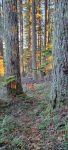
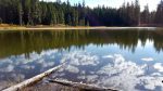
This is an interesting area seldom visited. One of the earliest trails in the area led here from the east. Likely that Indians gathered roots here, followed by trappers, and then shepherds. I am always struck by the variety of birds present at the meadows. Very buggy. Best in the Fall or late Summer. However, if you can get in just as the snow is out, you will be rewarded by a stunning variety of botanical diversity. Each of the meadows are quite different ecologies. There will be a lot of standing water in the early season. The upper trailhead is directly across the road from the Rimrock Trail. The trail continues at the far side of the first meadow which retains a seasonal body of water. At the second meadow, enter and keep right along the edge of the meadow and watch for the trail’s re-entry into the woods. A nice camp spot is across the meadow’s narrow north end and slightly to the left as you first enter the the meadow. Beyond this larger meadow and it’s lake pass through some micro-meadows or pools finding the trail at the far side each time. The third meadow opens on the right. Abundant wildflowers. Keep to the woods edge on the left and meet the road. The next 3/4 mile of the trail has been clearcut and not restored by the Forest Service. Beyond the clearcut resume a nice stretch of trail that starts at the end of the 5830-265 spur road. It continues in virgin timber to the trail’s end at the 4635-120 spur just west of the collapsed bridge over Cot Creek. Trail descends the ridge nearby. The entire route is approximately 3.3 miles in length.
Navigating the clearcut is not recommended for those without good directional skills. Basically, you want to follow the wash across the road south into an opening where two clearcuts merge. Walk across this open area keeping the uncut timber south of you on your left. Follow the cut line until you see the cut line curving left and then returning to the horizon on a small rise ahead. Walk across the clearcut at this time to the cut line on the rise. Just over the rise follow the cut line down to a road. Go right then left. Walk out to the end of the spur and follow ribbons down and slightly to the right to re-enter the virgin timber and continue the trail. The clearcut has not recovered very well and remains open featuring lots of beargrass and sun. It’s not unpleasant to walk across. Lots of wildlife. GPS co-ordinates are provided with the map to assist getting across the clearcut. If you come up from below during the Winter this is a nice area to snowshoe.
Directions
Northern Trailhead: Travel Hwy 224 thru Estacada to Ripplebrook. Continue thru Ripplebrook and immediately after crossing the river, turn left on Forest Service road 57. Go 7.2 miles to Forest Road 58. Turn left on Forest Road 58 and travel 3 miles to Forest Road 5830. Turn left on 5830 and travel approximately 3.5 miles to the trailhead on the left. There is no sign on the road but there is a sign down the trail a little bit. There is enough room to park on the side of the road.
Southern Trailhead: Travel Hwy 224 thru Estacada to Ripplebrook. Just past the Ripplebrook store, turn left on Forest Road 4631. Travel 4.1 miles to Forest Road 4635. Follow Forest Road 4635 for 1.1 miles to Forest Road 4635-120. Turn right on Forest Road 4635-120 and travel approximately 2.4 miles to the trailhead on the left. There is no sign, but you can see the ramp heading up from the road. There is a wide spot at the turn just south of the trailhead where you can park.
Map and Elevation Profile
Trip Reports
| Photo | Date | Report Summary |
|---|---|---|
 |
Nov 21, 2025 |
Very nice day for November.
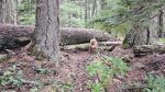
The road to the lower trailhead on 4635-120 was really muddy and slick from recent logging activity in the area. There are numerous logs across the trail until it comes out at the 5830-265 spur. The trail above the lake is in really good condition due to recent maintenance. On this trip we located a short isolated section of the trail NNW of the ...
|
 |
Aug 24, 2024 |
Trail is in need of some maintenance
The trail is in need of some maintenance. Very brushy in some places, and quite a few logs down. Upper Section is mostly just downed logs and brush (mostly huckleberries overgrowing the tread). Lower section (below 5830-265 spur) is extremely brushy in places – trail difficult to follow until you get into the old growth. If you decide to hike thi...
|
 |
Oct 17, 2015 |
A bit of blowdown but not bad
Trail in good shape, but has some blowdown – upper section (above 5830-240 spur) had about 25 logs down – lower section (below 5830-265 spur) had about 10-12 logs down. Slightly brushy in a few spots, but overall in good shape.
|